|
[#1]
Quoted:
Its not but there isn't much help there either. a few years ago they almost got hit by a tornado Quoted:
Quoted:
I hope Rio Vista is not very big. Heck, Glen Rose took a bad hit a few years ago. |
|
|
|
[#2]
Quoted:
Basehunters1 and Nick D. are driving into Rio Vista There are a ton of spotters in that area. maybe 30 or more. hard to tell on the map, they are stacked on top of each other. |
|
|
|
[#3]
Quoted:
Indeedy. Quoted:
Quoted:
Quoted:
Quoted:
Glen Rose area, possible round 2 coming your way. Beware. I'm not a storm spotter is that a hook echo west of glen rose? i just mentioned that to my wife, looks like it to me. The velocity images are starting to show more shear there, too. Won't be surprised if it gets warned. Posted Via AR15.Com Mobile |
|
|
|
[#4]
Quoted:
The velocity images are starting to show more shear there, too. Won't be surprised if it gets warned. Posted Via AR15.Com Mobile Quoted:
Quoted:
Quoted:
Quoted:
Quoted:
Glen Rose area, possible round 2 coming your way. Beware. I'm not a storm spotter is that a hook echo west of glen rose? i just mentioned that to my wife, looks like it to me. The velocity images are starting to show more shear there, too. Won't be surprised if it gets warned. Posted Via AR15.Com Mobile Cell U4 east of Glen Rose has an LLDV of 66kts and a max delta V of 87kts. |
|
|
|
[#5]
Rotation in the hook area. Blue moving opposite of green. 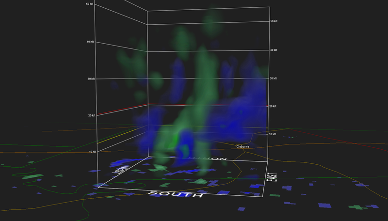 |
|
|
|
[#6]
Quoted:
Cell U4 east of Glen Rose has an LLDV of 66kts and a max delta V of 87kts. That's a whole lot of science talk there. 
|
|
|
|
[#7]
Does anyone know if they're expecting hail or tornadoes in Arlington, TX?
|
|
|
|
[#8]
Quoted: There are a ton of spotters in that area. maybe 30 or more. hard to tell on the map, they are stacked on top of each other. Quoted: Quoted: Basehunters1 and Nick D. are driving into Rio Vista There are a ton of spotters in that area. maybe 30 or more. hard to tell on the map, they are stacked on top of each other. |
|
|
|
[#9]
Quoted: That's a whole lot of science talk there. Quoted: Quoted: Cell U4 east of Glen Rose has an LLDV of 66kts and a max delta V of 87kts. That's a whole lot of science talk there. |
|
|
|
[#10]
Quoted: That's a whole lot of science talk there. Quoted: Quoted: Cell U4 east of Glen Rose has an LLDV of 66kts and a max delta V of 87kts. That's a whole lot of science talk there. |
|
|
|
[#11]
Quoted:
That's a whole lot of science talk there. Quoted:
Quoted:
Cell U4 east of Glen Rose has an LLDV of 66kts and a max delta V of 87kts. That's a whole lot of science talk there. It's pretty windy.  Posted Via AR15.Com Mobile |
|
|
|
[#12]
Quoted:
That's a whole lot of science talk there. Quoted:
Quoted:
Cell U4 east of Glen Rose has an LLDV of 66kts and a max delta V of 87kts. That's a whole lot of science talk there. LLDV= Low Level Delta Velocity. The velocity difference in advancing and retreating wind/whatever towards and away from the RADAR. When you see radar in velocity mode, green is moving towards the radar, red is moving away from. |
|
|
|
[#13]
Quoted:
Does anyone know if they're expecting hail or tornadoes in Arlington, TX? Its all way south of there. |
|
|
|
[#14]
Quoted:
Rotation in the hook area. Blue moving opposite of green. http://img.photobucket.com/albums/v732/pcsutton/Weather/Rotation%204-26-2015%20near%20Rio%20Vista_zpsyfgtvzt0.png Ah man. I had the trial version of GRLevel2 Analyst, and it expired. Seeing this makes me really want to shell out the 250 bones for it. I just have the GRLevel3 now. |
|
|
|
[#15]
Quoted:
Yeah, lots of them chasers. Many of us don't use it because we have weirdo stalkers believe it or not. One cocksucker was calculating driving speeds etc, and making a big deal about it on social networks online. Another reason why I don't do the live video anymore as well. Weirdos complaining about traffic infractions among other things. Quoted:
Quoted:
Quoted:
Basehunters1 and Nick D. are driving into Rio Vista There are a ton of spotters in that area. maybe 30 or more. hard to tell on the map, they are stacked on top of each other. A guy called me a few days ago from Arkansas to watch the weather in Beaumont because his daughter lives there.
|
|
|
|
[#16]
Quoted:
Means some wind is moving 66 knts in one direction and some wind is moving 87 knts....both in relation to the radar site. Quoted:
Quoted:
Quoted:
Cell U4 east of Glen Rose has an LLDV of 66kts and a max delta V of 87kts. That's a whole lot of science talk there. I like your answer the best. thanks! |
|
|
|
[#17]
larger more frequent hail now
|
|
|
|
[#18]
Quoted:
Its all way south of there. Quoted:
Quoted:
Does anyone know if they're expecting hail or tornadoes in Arlington, TX? Its all way south of there. Thanks! |
|
|
|
[#19]
Quoted:
A guy called me a few days ago from Arkansas to watch the weather in Beaumont because his daughter lives there. Quoted:
Quoted:
Quoted:
Quoted:
Basehunters1 and Nick D. are driving into Rio Vista There are a ton of spotters in that area. maybe 30 or more. hard to tell on the map, they are stacked on top of each other. A guy called me a few days ago from Arkansas to watch the weather in Beaumont because his daughter lives there. that's practically next door. |
|
|
|
[#20]
Quoted:
I like your answer the best. thanks! Quoted:
Quoted:
Quoted:
Quoted:
Cell U4 east of Glen Rose has an LLDV of 66kts and a max delta V of 87kts. That's a whole lot of science talk there. I like your answer the best. thanks! Wind is moving in one direction at 33kts, and wind very near it is moving in the opposite direction at 33kts. low Level means it is picked up in the 0.5 degree elevation sweep iirc. |
|
|
|
[#21]
Quoted: Ah man. I had the trial version of GRLevel2 Analyst, and it expired. Seeing this makes me really want to shell out the 250 bones for it. I just have the GRLevel3 now. Quoted: Quoted: Rotation in the hook area. Blue moving opposite of green. http://img.photobucket.com/albums/v732/pcsutton/Weather/Rotation%204-26-2015%20near%20Rio%20Vista_zpsyfgtvzt0.png Ah man. I had the trial version of GRLevel2 Analyst, and it expired. Seeing this makes me really want to shell out the 250 bones for it. I just have the GRLevel3 now. |
|
|
|
[#22]
Quoted:
I chase a lot of storms and have never used or have a need for analyst. Reason being are data packet sizes. Can't download them in the field. That's changing but still. Quoted:
Quoted:
Quoted:
Rotation in the hook area. Blue moving opposite of green. http://img.photobucket.com/albums/v732/pcsutton/Weather/Rotation%204-26-2015%20near%20Rio%20Vista_zpsyfgtvzt0.png Ah man. I had the trial version of GRLevel2 Analyst, and it expired. Seeing this makes me really want to shell out the 250 bones for it. I just have the GRLevel3 now. That's why I use GR3. It's more suited for spotting and chasing than gr2. Gr2 does give you pretty 3d volume scans though. This is also handy. 
|
|
|
|
[#23]
Quoted: Ah man. I had the trial version of GRLevel2 Analyst, and it expired. Seeing this makes me really want to shell out the 250 bones for it. I just have the GRLevel3 now. Quoted: Quoted: Rotation in the hook area. Blue moving opposite of green. http://img.photobucket.com/albums/v732/pcsutton/Weather/Rotation%204-26-2015%20near%20Rio%20Vista_zpsyfgtvzt0.png Ah man. I had the trial version of GRLevel2 Analyst, and it expired. Seeing this makes me really want to shell out the 250 bones for it. I just have the GRLevel3 now. If you chase or SKYWARN spot it's worth the dough. |
|
|
|
[#24]
Quoted:
If you chase or SKYWARN spot it's worth the dough. Quoted:
Quoted:
Quoted:
Rotation in the hook area. Blue moving opposite of green. http://img.photobucket.com/albums/v732/pcsutton/Weather/Rotation%204-26-2015%20near%20Rio%20Vista_zpsyfgtvzt0.png Ah man. I had the trial version of GRLevel2 Analyst, and it expired. Seeing this makes me really want to shell out the 250 bones for it. I just have the GRLevel3 now. The only thing I like about GR2 is being able to plot storm heading and velocity from previous scans, and the pretty volume renerings. Other than that I like GRlevel3. |
|
|
|
[#25]
Quoted: That's why I use GR3. It's more suited for spotting and chasing than gr2. Gr2 does give you pretty 3d volume scans though. This is also handy. http://i42.photobucket.com/albums/e308/rdxfusion/Mobile%20Uploads/image_zpskjrjjjzx.jpg~original Quoted: Quoted: Quoted: Quoted: Rotation in the hook area. Blue moving opposite of green. http://img.photobucket.com/albums/v732/pcsutton/Weather/Rotation%204-26-2015%20near%20Rio%20Vista_zpsyfgtvzt0.png Ah man. I had the trial version of GRLevel2 Analyst, and it expired. Seeing this makes me really want to shell out the 250 bones for it. I just have the GRLevel3 now. That's why I use GR3. It's more suited for spotting and chasing than gr2. Gr2 does give you pretty 3d volume scans though. This is also handy. http://i42.photobucket.com/albums/e308/rdxfusion/Mobile%20Uploads/image_zpskjrjjjzx.jpg~original I have used GR 3 for years. I also have Baron Satellite feed for some of the more rural areas. Lately believe it or not I have been just using radarscope. |
|
|
|
[#26]
Fancy tornado detector you have there... Hehehe. :)
|
|
|
|
[#27]
Taken at 10:33
 still coming |
|
|
|
[#28]
Hmm. I see two spots of interest: right over Rio Vista and immediately to the West.
Posted Via AR15.Com Mobile |
|
|
|
[#29]
Quoted:
Yeah, GR 2 is for desk chasers. :) I have used GR 3 for years. I also have Baron Satellite feed for some of the more rural areas. Lately believe it or not I have been just using radarscope. Quoted:
Quoted:
Quoted:
Quoted:
Quoted:
Rotation in the hook area. Blue moving opposite of green. http://img.photobucket.com/albums/v732/pcsutton/Weather/Rotation%204-26-2015%20near%20Rio%20Vista_zpsyfgtvzt0.png Ah man. I had the trial version of GRLevel2 Analyst, and it expired. Seeing this makes me really want to shell out the 250 bones for it. I just have the GRLevel3 now. That's why I use GR3. It's more suited for spotting and chasing than gr2. Gr2 does give you pretty 3d volume scans though. This is also handy. http://i42.photobucket.com/albums/e308/rdxfusion/Mobile%20Uploads/image_zpskjrjjjzx.jpg~original I have used GR 3 for years. I also have Baron Satellite feed for some of the more rural areas. Lately believe it or not I have been just using radarscope. I love radarscope. Its handy as hell on your phone or ipad. Thats what I take with me normaly. |
|
|
|
[#30]
Now we have a warning down here. Rotating cloud.
|
|
|
|
[#31]
Quoted: Now we have a warning down here. Rotating cloud. |
|
|
|
[#32]
Quoted:
Hmm. I see two spots of interest: right over Rio Vista and immediately to the West. Posted Via AR15.Com Mobile That little spot to the right of the TVS-8 is interesting. 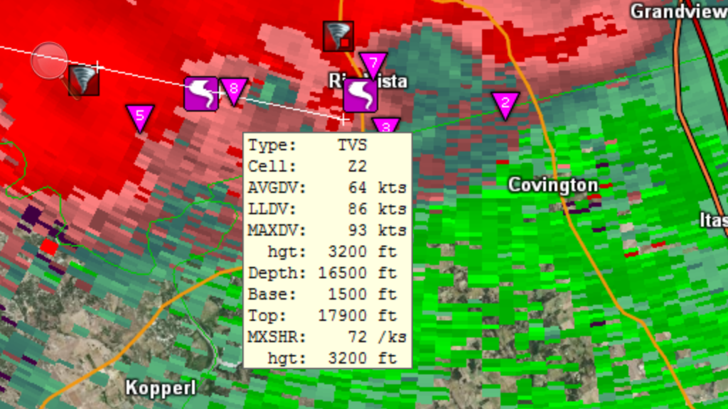
|
|
|
|
[#33]
Quoted:
Where down here be? Quoted:
Quoted:
Now we have a warning down here. Rotating cloud. Maybe here? 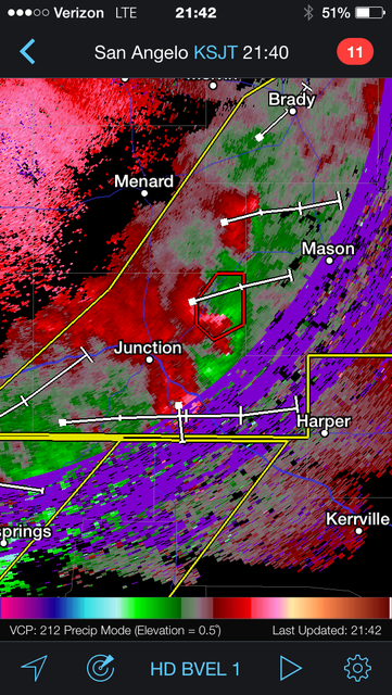 Posted Via AR15.Com Mobile |
|
|
|
[#34]
Quoted:
Now we have a warning down here. Rotating cloud. Quoted:
Now we have a warning down here. Rotating cloud. This? 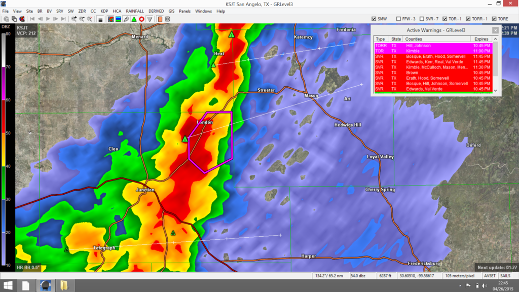
777
WWUS54 KSJT 270340 SVSSJT SEVERE WEATHER STATEMENT NATIONAL WEATHER SERVICE SAN ANGELO TX 1040 PM CDT SUN APR 26 2015 TXC327-270350- /O.CAN.KSJT.TO.W.0018.000000T0000Z-150427T0400Z/ MENARD TX- 1040 PM CDT SUN APR 26 2015 ...THE TORNADO WARNING FOR SOUTHEASTERN MENARD COUNTY IS CANCELLED... THE STORM WHICH PROMPTED THE WARNING HAS MOVED OUT OF THE WARNED AREA. LAT...LON 3071 9949 3058 9949 3054 9958 3058 9963 3064 9963 3071 9957 TIME...MOT...LOC 0340Z 239DEG 17KT 3062 9960 $$ TXC267-270400- /O.CON.KSJT.TO.W.0018.000000T0000Z-150427T0400Z/ KIMBLE TX- 1040 PM CDT SUN APR 26 2015 ...A TORNADO WARNING REMAINS IN EFFECT FOR NORTH CENTRAL KIMBLE COUNTY UNTIL 1100 PM CDT... AT 1037 PM CDT...A SEVERE THUNDERSTORM CAPABLE OF PRODUCING A TORNADO WAS LOCATED NEAR YATES...AND MOVING NORTHEAST AT 20 MPH. HAZARD...TORNADO AND QUARTER SIZE HAIL. SOURCE...RADAR INDICATED ROTATION. IMPACT...FLYING DEBRIS WILL BE DANGEROUS TO THOSE CAUGHT WITHOUT SHELTER. MOBILE HOMES WILL BE DAMAGED OR DESTROYED. DAMAGE TO ROOFS...WINDOWS AND VEHICLES WILL OCCUR. TREE DAMAGE IS LIKELY. THIS DANGEROUS STORM WILL BE NEAR... LONDON AROUND 1050 PM CDT. PRECAUTIONARY/PREPAREDNESS ACTIONS... TAKE COVER NOW. MOVE TO AN INTERIOR ROOM ON THE LOWEST FLOOR OF A STURDY BUILDING. AVOID WINDOWS. IF IN A MOBILE HOME...A VEHICLE OR OUTDOORS...MOVE TO THE CLOSEST SUBSTANTIAL SHELTER AND PROTECT YOURSELF FROM FLYING DEBRIS. && LAT...LON 3071 9949 3058 9949 3054 9958 3058 9963 3064 9963 3071 9957 TIME...MOT...LOC 0340Z 239DEG 17KT 3062 9960 TORNADO...RADAR INDICATED HAIL...1.00IN $$ ====================================================================== 121 WWUS54 KSJT 270334 SVSSJT SEVERE WEATHER STATEMENT NATIONAL WEATHER SERVICE SAN ANGELO TX 1034 PM CDT SUN APR 26 2015 TXC267-327-270400- /O.CON.KSJT.TO.W.0018.000000T0000Z-150427T0400Z/ KIMBLE TX-MENARD TX- 1034 PM CDT SUN APR 26 2015 ...A TORNADO WARNING REMAINS IN EFFECT FOR SOUTHEASTERN MENARD AND NORTH CENTRAL KIMBLE COUNTIES UNTIL 1100 PM CDT... AT 1033 PM CDT...A SEVERE THUNDERSTORM CAPABLE OF PRODUCING A TORNADO WAS LOCATED NEAR YATES...AND MOVING NORTHEAST AT 20 MPH. HAZARD...TORNADO AND QUARTER SIZE HAIL. SOURCE...RADAR INDICATED ROTATION. IMPACT...FLYING DEBRIS WILL BE DANGEROUS TO THOSE CAUGHT WITHOUT SHELTER. MOBILE HOMES WILL BE DAMAGED OR DESTROYED. DAMAGE TO ROOFS...WINDOWS AND VEHICLES WILL OCCUR. TREE DAMAGE IS LIKELY. THIS DANGEROUS STORM WILL BE NEAR... LONDON AROUND 1050 PM CDT. SALINE AROUND 1100 PM CDT. OTHER LOCATIONS IN THE WARNING INCLUDE US-377 NEAR THE KIMBLE-MENARD COUNTY LINE. PRECAUTIONARY/PREPAREDNESS ACTIONS... TAKE COVER NOW. MOVE TO AN INTERIOR ROOM ON THE LOWEST FLOOR OF A STURDY BUILDING. AVOID WINDOWS. IF IN A MOBILE HOME...A VEHICLE OR OUTDOORS...MOVE TO THE CLOSEST SUBSTANTIAL SHELTER AND PROTECT YOURSELF FROM FLYING DEBRIS. && LAT...LON 3080 9949 3055 9949 3051 9969 3065 9971 TIME...MOT...LOC 0335Z 239DEG 17KT 3061 9962 TORNADO...RADAR INDICATED HAIL...1.00IN $$ ====================================================================== 626 WFUS54 KSJT 270322 TORSJT TXC267-327-270400- /O.NEW.KSJT.TO.W.0018.150427T0322Z-150427T0400Z/ BULLETIN - EAS ACTIVATION REQUESTED TORNADO WARNING NATIONAL WEATHER SERVICE SAN ANGELO TX 1022 PM CDT SUN APR 26 2015 THE NATIONAL WEATHER SERVICE IN SAN ANGELO HAS ISSUED A * TORNADO WARNING FOR... NORTH CENTRAL KIMBLE COUNTY IN WEST CENTRAL TEXAS... SOUTHEASTERN MENARD COUNTY IN WEST CENTRAL TEXAS... * UNTIL 1100 PM CDT * AT 1021 PM CDT...A SEVERE THUNDERSTORM CAPABLE OF PRODUCING A TORNADO WAS LOCATED 8 MILES NORTH OF JUNCTION...AND MOVING NORTHEAST AT 30 MPH. HAZARD...TORNADO AND QUARTER SIZE HAIL. SOURCE...RADAR INDICATED ROTATION. IMPACT...FLYING DEBRIS WILL BE DANGEROUS TO THOSE CAUGHT WITHOUT SHELTER. MOBILE HOMES WILL BE DAMAGED OR DESTROYED. DAMAGE TO ROOFS...WINDOWS AND VEHICLES WILL OCCUR. TREE DAMAGE IS LIKELY. * THIS DANGEROUS STORM WILL BE NEAR... YATES AROUND 1040 PM CDT. LONDON AROUND 1045 PM CDT. SALINE AROUND 1050 PM CDT. OTHER LOCATIONS IN THE WARNING INCLUDE US-377 NEAR THE KIMBLE-MENARD COUNTY LINE. THIS INCLUDES INTERSTATE 10 BETWEEN MILE MARKERS 448 AND 454. PRECAUTIONARY/PREPAREDNESS ACTIONS... TAKE COVER NOW. MOVE TO AN INTERIOR ROOM ON THE LOWEST FLOOR OF A STURDY BUILDING. AVOID WINDOWS. IF IN A MOBILE HOME...A VEHICLE OR OUTDOORS...MOVE TO THE CLOSEST SUBSTANTIAL SHELTER AND PROTECT YOURSELF FROM FLYING DEBRIS. && LAT...LON 3080 9949 3055 9949 3048 9982 3070 9981 TIME...MOT...LOC 0323Z 246DEG 26KT 3061 9976 TORNADO...RADAR INDICATED HAIL...1.00IN |
|
|
|
[#35]
Mason.
ETA: We don't get many twisters. Not enough trailer parks. |
|
|
|
[#36]
Quoted:
That little spot to the right of the TVS-8 is interesting. http://i42.photobucket.com/albums/e308/rdxfusion/Screenshot%2064_zpswikfaqqu.png~original Quoted:
Quoted:
Hmm. I see two spots of interest: right over Rio Vista and immediately to the West. Posted Via AR15.Com Mobile That little spot to the right of the TVS-8 is interesting. http://i42.photobucket.com/albums/e308/rdxfusion/Screenshot%2064_zpswikfaqqu.png~original Yep. I'm only on radarscope so not sure what to make of it. Posted Via AR15.Com Mobile |
|
|
|
[#37]
Quoted:
I love radarscope. Its handy as hell on your phone or ipad. Thats what I take with me normaly. Quoted:
Quoted:
Yeah, GR 2 is for desk chasers. :) I have used GR 3 for years. I also have Baron Satellite feed for some of the more rural areas. Lately believe it or not I have been just using radarscope. I love radarscope. Its handy as hell on your phone or ipad. Thats what I take with me normaly. I love radarscope too, handy when I'm not near my computer. Full disclosure: I am not a chaser, merely an enthusiast. Which is why I haven't shelled out the dough for the analyst.
|
|
|
|
[#38]
I used to do a lot of net control and it was handy. Out chasing I avail myself of McDonalds free wifi to look at Analyst and SimuAWIPS to determine where I want to be. I also have Level 3. Once I'm running, I just use Radar Scope on my phone. If I need to update my plan, I just find free wifi. |
|
|
|
[#39]
Anyone have any updates about damage in or near Cleburne?
|
|
|
|
[#40]
Quoted:
Mason. ETA: We don't get many twisters. Not enough trailer parks. Still, though, you may want to duck & cover for a bit. Though that one may fizzle out. Posted Via AR15.Com Mobile |
|
|
|
[#41]
Quoted: I used to do a lot of net control and it was handy. Out chasing I avail myself of McDonalds free wifi to look at Analyst and SimuAWIPS to determine where I want to be. I also have Level 3. Once I'm running, I just use Radar Scope on my phone. If I need to update my plan, I just find free wifi. |
|
|
|
[#42]
Quoted: Anyone have any updates about damage in or near Cleburne? |
|
|
|
[#43]
quite a velocity return west of Rio Vista
|
|
|
|
[#44]
rio vista gas station awning ripped off and on railroad tracks
|
|
|
|
[#45]
Quoted: Anyone have any updates about damage in or near Cleburne? |
|
|
|
[#46]
mile-wide wedge #tornado 3 miles NE of Rio Vista, TX at 10:47pm
|
|
|
|
[#47]
Quoted: mile-wide wedge #tornado 3 miles NE of Rio Vista, TX at 10:47pm |
|
|
|
[#48]
Quoted:
quite a velocity return west of Rio Vista Not sure if this is what you are talking about but it is interesting, 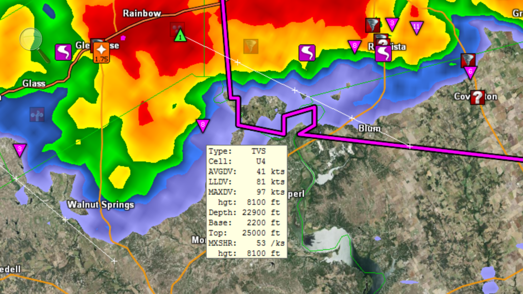
|
|
|
|
[#49]
Quoted:
I see 3 bad ass couplets on radarscope right now from Glen Rose to just east of Rio Vista Quoted:
Quoted:
mile-wide wedge #tornado 3 miles NE of Rio Vista, TX at 10:47pm yeah, it's not good.....seems to be converging into one giant storm 
|
|
|
|
[#50]
This thread has the most spectacularly well defined hook formations and doppler rotation examples I have ever seen, and I've been watching tornados on radar every summer since my early childhood... These pics belong in a textbook.
|
|
|
 Win a FREE Membership!
Sign up for the ARFCOM weekly newsletter and be entered to win a free ARFCOM membership. One new winner* is announced every week!
You will receive an email every Friday morning featuring the latest chatter from the hottest topics, breaking news surrounding legislation, as well as exclusive deals only available to ARFCOM email subscribers.

AR15.COM is the world's largest firearm community and is a gathering place for firearm enthusiasts of all types.
From hunters and military members, to competition shooters and general firearm enthusiasts, we welcome anyone who values and respects the way of the firearm.

Subscribe to our monthly Newsletter to receive firearm news, product discounts from your favorite Industry Partners, and more.
Copyright © 1996-2024 AR15.COM LLC. All Rights Reserved.
Any use of this content without express written consent is prohibited.
AR15.Com reserves the right to overwrite or replace any affiliate, commercial, or monetizable links, posted by users, with our own.