|
[#1]
Quoted: Wow, that's cool as hell. I mean, not cool that a plane crashed but that you can hike to the wreckage. Did you find some bags of reefer in the hull? If so, share them with your sexy hiking partner who's a romance author. I just saw that movie the other night  |
|
|
|
[#2]
Quoted: Looks like a Beechcraft Model 18 to me. http://en.wikipedia.org/wiki/Beechcraft_Model_18 http://i23.photobucket.com/albums/b367/thunderw21/more%20stuff/BeechcraftModel18.jpg that's what I was thinking |
|
|
|
[#3]
Wow, I just found that pic on Google Earth a few months ago. I camp and fish there frequently, so I was intrigued. I have searched and searched Google to find any news stories or anything and I never found anything. I began to wonder if the pic was in the wrong location. Now I'll add this to my list of places I need to go...
|
|
|
|
[#4]
Quoted:
Quoted:
Quoted:
It is definitely a Beechcraft Air Force C-45G or H model that went through airframe upgrade in the early 50's I can tell from the shot of the landing gear. It has the late model landing gear. I started flying those type airplanes in 1965. I restored my own (SNB-5 / UC-45J) in 1986 and am still flying it today. More than 5,000 were built during WWII for the military. They were used as AT-11 Bombardier, Navigator and AT-7 Pilot Trainers. Also used as Utility Transport. A small number were sent to the Chinese before U.S. entered the war and actually were small Bombers. Navy called them SNB. Another 4,000+ were civilian/corporate/air taxi/freighter. Production line operated from 1937 to 1969. Civilians called them a Twinbeech or Beech18. http://www.stinsonflyer.com/prop/be18-31.jpg Thank You big time for that pic!!!!!! It all adds up, right down to the black rubber material on the leading edge of the wing...... I can tell from a pic of the plane, alot of it has been hauled off over the years..... Awesome thread , thanks for putting it up. I wish we had cool stuff like that around here. |
|
|
|
[#5]
|
|
|
|
[#6]
Quoted: There was a hiking trail in Tucson I used to go on, that had an f-86 sabrejet crash still there. It was reportedly a mid-air collision with another. It had never been removed. It was pretty cool to hike by that. Where at? |
|
|
|
[#7]
Quoted:
Wow, I just found that pic on Google Earth a few months ago. I camp and fish there frequently, so I was intrigued. I have searched and searched Google to find any news stories or anything and I never found anything. I began to wonder if the pic was in the wrong location. Now I'll add this to my list of places I need to go... I thought too, it was another google earth pic in the wrong place...... I marked it on my GPS where I thought it may be, and by god it was there...... There is no trail to the plane per-say, it's a 200yds hike up the holler  to the plane from the laurel river trail..... to the plane from the laurel river trail.....
I have camped Laurel fork since a young pup (I'm 24) My grand-pa pretty much raised me over there int he summer camping. I never while he was alive heard him mention it, and I know he had hunted that area for years..... |
|
|
|
[#8]
Quoted:
Quoted:
Wow, I just found that pic on Google Earth a few months ago. I camp and fish there frequently, so I was intrigued. I have searched and searched Google to find any news stories or anything and I never found anything. I began to wonder if the pic was in the wrong location. Now I'll add this to my list of places I need to go... I thought too, it was another google earth pic in the wrong place...... I marked it on my GPS where I thought it may be, and by god it was there...... There is no trail to the plane per-say, it's a 200yds hike up the holler to the plane from the laurel river trail.....
I have camped Laurel fork since a young pup (I'm 24) My grand-pa pretty much raised me over there int he summer camping. I never while he was alive heard him mention it, and I know he had hunted that area for years..... Too cool. Do you live near there? I'm up in Fairmont, but try to get down there as much as I can. Fly fishing and camping. Now I see the pic was uploaded in February, I was gonna say I've been over most every square inch of the National Forest in Google Earth over the years and I knew I'd never seen it before. New destination to check out next spring during trout stocking. |
|
|
|
[#9]
Quoted:
Quoted:
Quoted:
Looks like an Aircoupe/Ercoupe. That looks like a winner!!!!!! The tail matches up, the wings seem to look right, and the laeding edges of the wings did have some sort of rubber on them like in the pic I found here..... http://upload.wikimedia.org/wikipedia/commons/thumb/2/26/COREL_360039.png/800px-COREL_360039.png Did the Air Force have any of these?????? Where's N_T now that we Really need him 
Who cares? |
|
|
|
[#10]
Quoted:
It was about 150yds up a holler off the trial I was hiking in a dry creek......  Translation for stupid yankees: hollow. |
|
|
|
[#11]
Quoted: If that happened today, the environmental POLICE would make them remove every scrap, and return the forest to it's "PRESTINE" condition.... Actually the idea of a wilderness is to leave everything as-is I am not sure if this was in a wilderness area but I think you are a little mixed up or at least kind of paranoid. If a tree falls on a trail climb over it there is no maintenance and I am not sure if I have ever heard of these "environmental police". |
|
|
|
[#12]
Quoted:
Quoted:
Quoted:
Wow, I just found that pic on Google Earth a few months ago. I camp and fish there frequently, so I was intrigued. I have searched and searched Google to find any news stories or anything and I never found anything. I began to wonder if the pic was in the wrong location. Now I'll add this to my list of places I need to go... I thought too, it was another google earth pic in the wrong place...... I marked it on my GPS where I thought it may be, and by god it was there...... There is no trail to the plane per-say, it's a 200yds hike up the holler to the plane from the laurel river trail.....
I have camped Laurel fork since a young pup (I'm 24) My grand-pa pretty much raised me over there int he summer camping. I never while he was alive heard him mention it, and I know he had hunted that area for years..... Too cool. Do you live near there? I'm up in Fairmont, but try to get down there as much as I can. Fly fishing and camping. Now I see the pic was uploaded in February, I was gonna say I've been over most every square inch of the National Forest in Google Earth over the years and I knew I'd never seen it before. New destination to check out next spring during trout stocking. I'm over South of Elkins, near Beverly... I haven't had the time to go fishing in forever. Pretty much since my grandpa died back in 03' I hadn't been to laurel fork alot. I just started getting back and exploring more stuff that I never knew was there when I was a young buck
|
|
|
|
[#13]
Quoted:
Quoted:
If that happened today, the environmental POLICE would make them remove every scrap, and return the forest to it's "PRESTINE" condition.... Actually the idea of a wilderness is to leave everything as-is I am not sure if this was in a wilderness area but I think you are a little mixed up or at least kind of paranoid. If a tree falls on a trail climb over it there is no maintenance and I am not sure if I have ever heard of these "environmental police". This was in a Wilderness area, but it was only designated in 1983 i think....This plane went down in the 50's-60's so they hauled most of the stuff out years ago.... |
|
|
|
[#14]
Quoted:
I'm over South of Elkins, near Beverly... I haven't had the time to go fishing in forever. Pretty much since my grandpa died back in 03' I hadn't been to laurel fork alot. I just started getting back and exploring more stuff that I never knew was there when I was a young buck Cool. Drove through there last weekend as I took my son backpacking up the East Fork of the Greenbrier. |
|
|
|
[#15]
Quoted:
Quoted:
Quoted:
Quoted:
Wow, I just found that pic on Google Earth a few months ago. I camp and fish there frequently, so I was intrigued. I have searched and searched Google to find any news stories or anything and I never found anything. I began to wonder if the pic was in the wrong location. Now I'll add this to my list of places I need to go... I thought too, it was another google earth pic in the wrong place...... I marked it on my GPS where I thought it may be, and by god it was there...... There is no trail to the plane per-say, it's a 200yds hike up the holler to the plane from the laurel river trail.....
I have camped Laurel fork since a young pup (I'm 24) My grand-pa pretty much raised me over there int he summer camping. I never while he was alive heard him mention it, and I know he had hunted that area for years..... Too cool. Do you live near there? I'm up in Fairmont, but try to get down there as much as I can. Fly fishing and camping. Now I see the pic was uploaded in February, I was gonna say I've been over most every square inch of the National Forest in Google Earth over the years and I knew I'd never seen it before. New destination to check out next spring during trout stocking. I'm over South of Elkins, near Beverly... I haven't had the time to go fishing in forever. Pretty much since my grandpa died back in 03' I hadn't been to laurel fork alot. I just started getting back and exploring more stuff that I never knew was there when I was a young buck You should take the train out of Elkins down the valley - no roads there. http://mountainrailwv.com/choose-a-train/cheat-mountain-salamander 
Beautiful country you have down there, btw - 'cept the one lane traffic for all the water lines they are laying bites the big one. |
|
|
|
[#16]
Quoted: Quoted: It is definitely a Beechcraft Air Force C-45G or H model that went through airframe upgrade in the early 50's I can tell from the shot of the landing gear. It has the late model landing gear. I started flying those type airplanes in 1965. I restored my own (SNB-5 / UC-45J) in 1986 and am still flying it today. More than 5,000 were built during WWII for the military. They were used as AT-11 Bombardier, Navigator and AT-7 Pilot Trainers. Also used as Utility Transport. A small number were sent to the Chinese before U.S. entered the war and actually were small Bombers. Navy called them SNB. Another 4,000+ were civilian/corporate/air taxi/freighter. Production line operated from 1937 to 1969. Civilians called them a Twinbeech or Beech18. http://www.stinsonflyer.com/prop/be18-31.jpg Agreed...model 18 or AF designation of same. A sweet plane. |
|
|
|
[#17]
Did you find any money
|
|
|
|
[#18]
Quoted:
Quoted:
Quoted:
Quoted:
Quoted:
Wow, I just found that pic on Google Earth a few months ago. I camp and fish there frequently, so I was intrigued. I have searched and searched Google to find any news stories or anything and I never found anything. I began to wonder if the pic was in the wrong location. Now I'll add this to my list of places I need to go... I thought too, it was another google earth pic in the wrong place...... I marked it on my GPS where I thought it may be, and by god it was there...... There is no trail to the plane per-say, it's a 200yds hike up the holler to the plane from the laurel river trail.....
I have camped Laurel fork since a young pup (I'm 24) My grand-pa pretty much raised me over there int he summer camping. I never while he was alive heard him mention it, and I know he had hunted that area for years..... Too cool. Do you live near there? I'm up in Fairmont, but try to get down there as much as I can. Fly fishing and camping. Now I see the pic was uploaded in February, I was gonna say I've been over most every square inch of the National Forest in Google Earth over the years and I knew I'd never seen it before. New destination to check out next spring during trout stocking. I'm over South of Elkins, near Beverly... I haven't had the time to go fishing in forever. Pretty much since my grandpa died back in 03' I hadn't been to laurel fork alot. I just started getting back and exploring more stuff that I never knew was there when I was a young buck You should take the train out of Elkins down the valley - no roads there. http://mountainrailwv.com/choose-a-train/cheat-mountain-salamander http://mountainrailwv.com/mountain-rails/1-rt-map.jpg Beautiful country you have down there, btw - 'cept the one lane traffic for all the water lines they are laying bites the big one. Hell, i can hike that for cheaper than that train costs!!! I've been to most of those places on foot already..... by one lane traffic, are you referring to rt.33 on the mountain?? There widening it out for a truck lane all the way up it. Key is to go on the weekends |
|
|
|
[#19]
Quoted:
Quoted:
Quoted:
Quoted:
Quoted:
Quoted:
Wow, I just found that pic on Google Earth a few months ago. I camp and fish there frequently, so I was intrigued. I have searched and searched Google to find any news stories or anything and I never found anything. I began to wonder if the pic was in the wrong location. Now I'll add this to my list of places I need to go... I thought too, it was another google earth pic in the wrong place...... I marked it on my GPS where I thought it may be, and by god it was there...... There is no trail to the plane per-say, it's a 200yds hike up the holler to the plane from the laurel river trail.....
I have camped Laurel fork since a young pup (I'm 24) My grand-pa pretty much raised me over there int he summer camping. I never while he was alive heard him mention it, and I know he had hunted that area for years..... I think he's talking about South of Beverley down to Huttonsville. Too cool. Do you live near there? I'm up in Fairmont, but try to get down there as much as I can. Fly fishing and camping. Now I see the pic was uploaded in February, I was gonna say I've been over most every square inch of the National Forest in Google Earth over the years and I knew I'd never seen it before. New destination to check out next spring during trout stocking. I'm over South of Elkins, near Beverly... I haven't had the time to go fishing in forever. Pretty much since my grandpa died back in 03' I hadn't been to laurel fork alot. I just started getting back and exploring more stuff that I never knew was there when I was a young buck You should take the train out of Elkins down the valley - no roads there. http://mountainrailwv.com/choose-a-train/cheat-mountain-salamander http://mountainrailwv.com/mountain-rails/1-rt-map.jpg Beautiful country you have down there, btw - 'cept the one lane traffic for all the water lines they are laying bites the big one. Hell, i can hike that for cheaper than that train costs!!! I've been to most of those places on foot already..... by one lane traffic, are you referring to rt.33 on the mountain?? There widening it out for a truck lane all the way up it. Key is to go on the weekends I think he's talking about 219/250 South of Beverly to Huttonsville. |
|
|
|
[#20]
Quoted:
Quoted:
Quoted:
Quoted:
Quoted:
Quoted:
Wow, I just found that pic on Google Earth a few months ago. I camp and fish there frequently, so I was intrigued. I have searched and searched Google to find any news stories or anything and I never found anything. I began to wonder if the pic was in the wrong location. Now I'll add this to my list of places I need to go... I thought too, it was another google earth pic in the wrong place...... I marked it on my GPS where I thought it may be, and by god it was there...... There is no trail to the plane per-say, it's a 200yds hike up the holler to the plane from the laurel river trail.....
I have camped Laurel fork since a young pup (I'm 24) My grand-pa pretty much raised me over there int he summer camping. I never while he was alive heard him mention it, and I know he had hunted that area for years..... Too cool. Do you live near there? I'm up in Fairmont, but try to get down there as much as I can. Fly fishing and camping. Now I see the pic was uploaded in February, I was gonna say I've been over most every square inch of the National Forest in Google Earth over the years and I knew I'd never seen it before. New destination to check out next spring during trout stocking. I'm over South of Elkins, near Beverly... I haven't had the time to go fishing in forever. Pretty much since my grandpa died back in 03' I hadn't been to laurel fork alot. I just started getting back and exploring more stuff that I never knew was there when I was a young buck You should take the train out of Elkins down the valley - no roads there. http://mountainrailwv.com/choose-a-train/cheat-mountain-salamander http://mountainrailwv.com/mountain-rails/1-rt-map.jpg Beautiful country you have down there, btw - 'cept the one lane traffic for all the water lines they are laying bites the big one. Hell, i can hike that for cheaper than that train costs!!! I've been to most of those places on foot already..... by one lane traffic, are you referring to rt.33 on the mountain?? There widening it out for a truck lane all the way up it. Key is to go on the weekends Actually I was thinking of 219 south out of Elkins. Must have spent a good 1/2 hour there waiting on WVDOH to stop yakking and let traffic go the other way. Once 250 splits off (Huttonsville?) 219 was terrific. What a sweet drive with beautiful (and clean!) countryside. Came back through Durbin & 33 and that wasn't near as bad. |
|
|
|
[#21]
Quoted:
Quoted:
Quoted:
Quoted:
Quoted:
Quoted:
Quoted:
Wow, I just found that pic on Google Earth a few months ago. I camp and fish there frequently, so I was intrigued. I have searched and searched Google to find any news stories or anything and I never found anything. I began to wonder if the pic was in the wrong location. Now I'll add this to my list of places I need to go... I thought too, it was another google earth pic in the wrong place...... I marked it on my GPS where I thought it may be, and by god it was there...... There is no trail to the plane per-say, it's a 200yds hike up the holler to the plane from the laurel river trail.....
I have camped Laurel fork since a young pup (I'm 24) My grand-pa pretty much raised me over there int he summer camping. I never while he was alive heard him mention it, and I know he had hunted that area for years..... I think he's talking about South of Beverley down to Huttonsville. Too cool. Do you live near there? I'm up in Fairmont, but try to get down there as much as I can. Fly fishing and camping. Now I see the pic was uploaded in February, I was gonna say I've been over most every square inch of the National Forest in Google Earth over the years and I knew I'd never seen it before. New destination to check out next spring during trout stocking. I'm over South of Elkins, near Beverly... I haven't had the time to go fishing in forever. Pretty much since my grandpa died back in 03' I hadn't been to laurel fork alot. I just started getting back and exploring more stuff that I never knew was there when I was a young buck You should take the train out of Elkins down the valley - no roads there. http://mountainrailwv.com/choose-a-train/cheat-mountain-salamander http://mountainrailwv.com/mountain-rails/1-rt-map.jpg Beautiful country you have down there, btw - 'cept the one lane traffic for all the water lines they are laying bites the big one. Hell, i can hike that for cheaper than that train costs!!! I've been to most of those places on foot already..... by one lane traffic, are you referring to rt.33 on the mountain?? There widening it out for a truck lane all the way up it. Key is to go on the weekends I think he's talking about 219/250 South of Beverly to Huttonsville. Ahh well could be, I haven't been up there in a few weeks.... |
|
|
|
[#22]
Quoted:
Quoted:
Quoted:
Quoted:
Quoted:
Quoted:
Quoted:
Wow, I just found that pic on Google Earth a few months ago. I camp and fish there frequently, so I was intrigued. I have searched and searched Google to find any news stories or anything and I never found anything. I began to wonder if the pic was in the wrong location. Now I'll add this to my list of places I need to go... I thought too, it was another google earth pic in the wrong place...... I marked it on my GPS where I thought it may be, and by god it was there...... There is no trail to the plane per-say, it's a 200yds hike up the holler to the plane from the laurel river trail.....
I have camped Laurel fork since a young pup (I'm 24) My grand-pa pretty much raised me over there int he summer camping. I never while he was alive heard him mention it, and I know he had hunted that area for years..... Too cool. Do you live near there? I'm up in Fairmont, but try to get down there as much as I can. Fly fishing and camping. Now I see the pic was uploaded in February, I was gonna say I've been over most every square inch of the National Forest in Google Earth over the years and I knew I'd never seen it before. New destination to check out next spring during trout stocking. I'm over South of Elkins, near Beverly... I haven't had the time to go fishing in forever. Pretty much since my grandpa died back in 03' I hadn't been to laurel fork alot. I just started getting back and exploring more stuff that I never knew was there when I was a young buck You should take the train out of Elkins down the valley - no roads there. http://mountainrailwv.com/choose-a-train/cheat-mountain-salamander http://mountainrailwv.com/mountain-rails/1-rt-map.jpg Beautiful country you have down there, btw - 'cept the one lane traffic for all the water lines they are laying bites the big one. Hell, i can hike that for cheaper than that train costs!!! I've been to most of those places on foot already..... by one lane traffic, are you referring to rt.33 on the mountain?? There widening it out for a truck lane all the way up it. Key is to go on the weekends Actually I was thinking of 219 south out of Elkins. Must have spent a good 1/2 hour there waiting on WVDOH to stop yakking and let traffic go the other way. Once 250 splits off (Huttonsville?) 219 was terrific. What a sweet drive with beautiful (and clean!) countryside. Came back through Durbin & 33 and that wasn't near as bad. You sir have found my secret places I know the top of cheat mountain on 250 like the back of my hand, done alot of hiking up there tooThis is my backyard, I pretty much use the Nat. forest as such. I can hike a different trail every weekend, and never repeat one |
|
|
|
[#23]
Quoted:
Quoted:
Actually I was thinking of 219 south out of Elkins. Must have spent a good 1/2 hour there waiting on WVDOH to stop yakking and let traffic go the other way. Once 250 splits off (Huttonsville?) 219 was terrific. What a sweet drive with beautiful (and clean!) countryside. Came back through Durbin & 33 and that wasn't near as bad. You sir have found my secret places I know the top of cheat mountain on 250 like the back of my hand, done alot of hiking up there tooThis is my backyard, I pretty much use the Nat. forest as such. I can hike a different trail every weekend, and never repeat one You live in paradise. Few people in the east have any idea what beautiful places still exist. And that's probably why they are still around. |
|
|
|
[#24]
Recorded Military C-45 crash's in VA that I found.
I know they're nowhere near you. Date: 55 06 18 Aircraft: TC-45G USAF Serial: 51-11536 Group: 3615FTW Home Base: Craig AFB, AL Reason: Crash Belly Landing Out of Gas Killed: 4 Pilot: Fletcher, Arthur Jr Location: 10M S Richmond, VA Date: 55 11 10 Aircraft: C-45H USAF Serial: 52-10742 Group: Hq ARDC Home Base: AEDC, Tullahoma, TN AF: ARDC Reason: Bailed Out Due To Engine Fire Killed: 4 Pilot: Raddin, James Hallow USA Location: 18 mi NW of Galax, VA |
|
|
|
[#25]
Guys, I do kinda wonder about something else I noticed on the plane......All of the wings had a yellow cross sloppily painted on them. I thought maybe it was from after the crash, but it's on the underside of the rear wings, not a easy place to paint post crash.....
Also, where can I find the aircraft ser## I can go back and try to find it if need be...... 

|
|
|
|
[#26]
I know there is another plane crash up on the mountain from Judy Springs near Seneca Rocks. Some guy and his girlfriend crashed there in the 70's and the guy's parents would hike into the site every year on the anniversary of the crash up until a few years ago. They would leave a note every year in a small glass jar that was underneath some make shift crosses.
|
|
|
|
[#27]
LOL, I saw plane wreckage near Dolly Sods in 1979, and it looked like it had been there quite a while back then.
There's a B52 in Savage State Forest in western MD, pretty easy hike. Went down in a blizzard in '64. |
|
|
|
[#28]
Quoted: LOL, I saw plane wreckage near Dolly Sods in 1979, and it looked like it had been there quite a while back then. There's a B52 in Savage State Forest in western MD, pretty easy hike. Went down in a blizzard in '64. This could be the same one that I've seen a few times. |
|
|
|
[#29]
Quoted:
It was about 150yds up a holler off the trial I was hiking in a dry creek...... WHAT? You don't know what a holler is? |
|
|
|
[#30]
Really neat find. Much more interesting that the crap I find out hiking. Surprising those panels with markings have survived the hikers this long.
|
|
|
|
[#31]
Quoted:
Quoted:
It was about 150yds up a holler off the trial I was hiking in a dry creek...... Translation for stupid yankees: hollow. That there headless horseman feller lived up Sleepy Holler, right? |
|
|
|
[#32]
Quoted:
Quoted:
Quoted:
It was about 150yds up a holler off the trial I was hiking in a dry creek...... Translation for stupid yankees: hollow. That there headless horseman feller lived up Sleepy Holler, right? yep..... |
|
|
|
[#33]
LOL guessing you didn't live/or pay attention during the Clinton years |
|
|
|
[#34]
Quoted:
Guys, I do kinda wonder about something else I noticed on the plane......All of the wings had a yellow cross sloppily painted on them. I thought maybe it was from after the crash, but it's on the underside of the rear wings, not a easy place to paint post crash..... Also, where can I find the aircraft ser## I can go back and try to find it if need be...... http://i67.photobucket.com/albums/h313/joe7170/Laurel%20Fork%20South/IM000065.jpg http://i67.photobucket.com/albums/h313/joe7170/Laurel%20Fork%20South/IM000056.jpg The crosses might have been applied by the rescue people or by the relatives of the people in the crash. Go to airliners.net and do a search - http://www.airliners.net/photo/Untitled/Beech-C-45H-Expeditor/1377341/M/&sid=7f2d00a5b0da9b3f4a3b84cd280c5b00 Your pictures show that the serial numbers on the side of the fuselage was hacked away a long time ago. Look for "identiplates", they will be metal tags will all sorts of information on them. They should be on all of the major parts of the aircraft. 
|
|
|
|
[#35]
Here's a pic of the right wing laying right side up.......It has a faint AF on it, so the US may still be there....

Here's the left wing right side up... It's the one with the star..... 
Now, compare all of that to the pic here..... 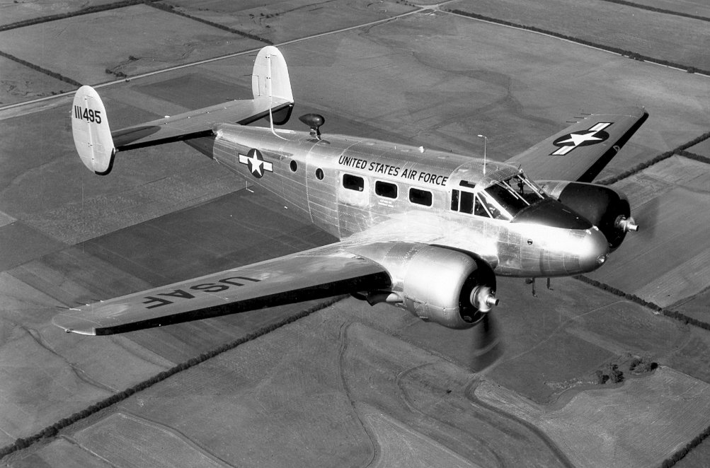
The markings sure make sense.... The leading edges of the wings are all gone, but I guess hitting trees would do that.... |
|
|
|
[#36]
Quoted: Quoted: Quoted: It was about 150yds up a holler off the trial I was hiking in a dry creek...... Lemmie guess you live up north some where? Damn it, I live in WV give me a break on english I grew up in East TN, I knew exactly what you were saying. |
|
|
|
[#37]
Quoted:
Quoted:
Quoted:
Quoted:
It was about 150yds up a holler off the trial I was hiking in a dry creek...... Lemmie guess you live up north some where? Damn it, I live in WV give me a break on english I grew up in East TN, I knew exactly what you were saying.
|
|
|
|
[#38]
I just read your IM about this. The locals told me that plane was up there. I probably walked right by it. A Navy MH-60 Nighthawk crashed above Green Bank this past winter. They hoisted most of it out though. http://www.redorbit.com/news/space/1915936/observatory_staff_aid_in_military_helicopter_crash_rescue/ |
|
|
|
[#39]
Quoted:
Those are some amazing pics! Its crazy to walk up on something like that in the woods. Its like taking a trip back in time And tell the gubment to come clean thier junk up. Thats a nice piece of woods |
|
|
|
[#40]
TAG for ID of plane
|
|
|
|
[#41]
Quoted:
Quoted:
Guys, I do kinda wonder about something else I noticed on the plane......All of the wings had a yellow cross sloppily painted on them. I thought maybe it was from after the crash, but it's on the underside of the rear wings, not a easy place to paint post crash..... Also, where can I find the aircraft ser## I can go back and try to find it if need be...... http://i67.photobucket.com/albums/h313/joe7170/Laurel%20Fork%20South/IM000065.jpg http://i67.photobucket.com/albums/h313/joe7170/Laurel%20Fork%20South/IM000056.jpg The crosses might have been applied by the rescue people or by the relatives of the people in the crash. Go to airliners.net and do a search - http://www.airliners.net/photo/Untitled/Beech-C-45H-Expeditor/1377341/M/&sid=7f2d00a5b0da9b3f4a3b84cd280c5b00 Your pictures show that the serial numbers on the side of the fuselage was hacked away a long time ago. Look for "identiplates", they will be metal tags will all sorts of information on them. They should be on all of the major parts of the aircraft. http://www.zianet.com/tmorris/49-075%20plaka%20V2.jpg Could the ser## be stamped into any of the metal pieces?? I'm trying to think of any of the parts left that may be marked... maybe whats left of the end of the vertical stabilizers?? The painted crosses I guess could be from the rescue team, since they look so sloppy on there.....I have no idea why the underside of the rear wings would have it, unless they rolled it over??? I know the cross with the flowers may indicate someone died in the crash.... If I could find out for sure, I'd take some new flowers or something up there, those men need not be forgotten.... |
|
|
|
[#42]
Quoted:
I just read your IM about this. The locals told me that plane was up there. I probably walked right by it. A Navy MH-60 Nighthawk crashed above Green Bank this past winter. They hoisted most of it out though. http://www.redorbit.com/news/space/1915936/observatory_staff_aid_in_military_helicopter_crash_rescue/ Yeah, the nighthawk crash was big news up here. Went down in a big ice storm. Took a day or so to get to it from the ground, had snow drifts up to 10ft up there..... It was on the east side of Bald Knob i think... That was really hush hush from the navy, they would not let anyone over the site, covered it with a tent and all till they hauled it out... |
|
|
|
[#43]
Story on that:
Observatory Staff Aid in Military Helicopter Crash Rescue 
By Karen O’Neil and Mike Holstine, National Radio Astronomy Observatory
posted: 03 September 2010 11:06 am ET The National Radio Astronomy Observatory's Robert C. Byrd Green Bank Telescope is the world's largest fully steerable telescope, an incredibly sensitive instrument which can detect complex molecules such as sugar (glycoaldehyde) in space, measure minuscule fluctuations in gravitational fields from gravitational waves and map primordial gas feeding star formation within the Milky Way. The NRAO staff in Green Bank, West Virginia, typically spend their day working to maximize the scientific output of the telescope through maintenance, instrument development, and aiding the wide variety of scientists whose peer-reviewed scientific observations are scheduled on the telescope. February 18, 2010 was ending like any other day at the site — the telescope was observing the motion of galaxies in the nearby universe, and the majority of employees had already left for the day. In this serene mountain valley, it is not uncommon to hear the roar of military jet fighters close by as they train in the nearby Evers Military Operations Area. This evening, though, brought the sound of two West Virginia Army National Guard HH-60 Blackhawk helicopters to the site itself, and it was clear that something was amiss. Christine Plumley, the site Associate Business Manager, was leaving her office when she spotted the helicopters landing on the site airstrip. She grabbed Butch Wirt, the Facility Engineer, and drove to the aircraft to determine why they had landed. Christine and Butch were met by Major Kevin Hazuka of the W.V. Army National Guard (ANG), who was piloting the aircraft. He had just dropped two of his medics off at the crash site of a Navy MH-60 Nighthawk helicopter that had been participating in a joint military training exercise, and the helicopter had crashed en route from Ft. Pickett, Va. to Camp Dawson in W.V. Maj. Hazuka and his crew had been searching for the downed aircraft and its crew of 17 since about 2:00 p.m. that afternoon. The weather was cold and snowing and the Navy helicopter had crashed in an extremely remote area of mountainous Pocahontas County. Bringing him to the Jansky Lab, a building typically used for staff offices, workspaces, and equipment rooms, Christine offered the use of the phones so that Maj. Hazuka could begin to make calls to his command center. One of the Blackhawks that set down with Kevin had mechanical problems and Kevin's chopper was nearly out of fuel. He called for refueling trucks from the nearest ANG Incident Command Center — in Parkersburg, W.V., about four hours' drive from the Green Bank site — and then coordinated his team to begin a rescue plan. The site Unicom system, which operates in the aircraft frequencies, allowed Kevin to talk to a C-130 plane brought in to circle the crash site and relay information to the ground crew. Christine called Mike Holstine, the site Business Manager, Karen O’Neil, the Green Bank site director, and a number of other NRAO employees who volunteered their time (and sleep) to help out with what would turn into a 40 hour, round-the-clock battle against time to set up a command center, aid in the formulation of a plan to rescue the downed crew, and support the military operation in every way possible. Local volunteer firefighters and rescue personnel from the Bartow-Frank-Durbin (BFD) Fire and Rescue squad, many of whom are also NRAO employees, converged on the site, as did news media from the region. Once final coordinates of the downed craft were obtained, Holstine was able to generate 3D elevation maps of the crash site and overall topographic and photo maps of the terrain. Knowing the mountainous terrain well, the BFD members were well aware of the considerable difficulties they were going to face in reaching the crew. NRAO's offices and conference rooms were rapidly turned into command posts for communications and the command center for the ANG. While the ANG focused on coordinating the heroic rescue effort undertaken to bring medics and crews the approximately seven miles, through the five- to eight-foot snow drifts, to rescue the downed soldiers, NRAO staff came in to prepare food, drink, and beds (in the small, on-site student bunkhouse) for the hungry and exhausted ANG soldiers at the NRAO command center. NRAO staff also came in to plow the airstrip of snow, which had been accumulating in the area for the last two months, as well as to open the machine shop for the helicopter crews and supply them with ladders and tools for the repair of one of the Blackhawks. The site of the crash was almost halfway between the closest main road through the county, Route 92 at Cheat Bridge, and the Snowshoe Ski Resort. Coordination with the Shaver's Fork Fire and Rescue team at Snowshoe allowed rescuers to reach the crash site within several hours and finally retrieve the last of the crewmembers by noon the next day. Incredibly, there were no fatalities in the crash and all crew members are expected to make a full recovery. This amazing result is all the more astounding when you realize that the temperature that night dropped to 17 degrees Fahrenheit and the crash site was in an extremely remote, mountainous and snowy area. The Navy and Army National Guard recognized employees of the NRAO NFS facility on March 10, 2010, at a ceremony in Elkins, W.V., and by the Governor of West Virginia at a ceremony held at Snowshoe Resort on March 27, 2010. As stated by the ANG, their "tireless efforts, dedication to the mission, failure to yield to exhaustion, unyielding assistance, and hospitality" aided in the overall success in bringing these service men and women home and demonstrating the importance of the NSF in local communities beyond the normal mission. As a follow-up to the crash, on April 21, 2010, about 20 US Army National Guard and Navy personnel arrived at the Green Bank site to recover the remains of the downed helicopter. Three Blackhawks and a CH-47 Chinook helicopter brought the helicopter remains back to the Green Bank site. The salvage craft was lowered to the ground and the NRAO crane was used to pick the airframe from the ground and load it onto a lowboy Navy tractor trailer. The GBT forklift was used to load all of the basket parts into a Navy cargo truck. By 6:00 p.m. on April 22, the operation was complete and all personnel were headed back to their respective stations. All persons in the community who volunteered their time and efforts for this astounding rescue are to be greatly applauded for their work. In addition to those named above, we particularly would also like to thank NRAO employees Pete Chestnut, Philip Doolittle, Helen Coleman, John Ford, Dave McPaters, Mary Meeks, Ellen Ryder, H.A. Taylor, Dave Vandevender, Galen Watts, and Tim Weadon for their efforts. |
|
|
|
[#44]
Hey I forgot to add, if any of you fellas get up there, and find my walking stick, stuck in that log next to the wing, you can have it, I forgot it. That stick has alot of miles on it
It's there sticking up next to my pack..... 
|
|
|
|
[#45]
The locale's a little off:
This C-45-H Expeditor #52-10571A ...aircraft is now on display at the museum...
This scale model aircraft represents the one in the 7 September 1958 crash where four lives were lost. The aircraft stationed at Bakalar Air Force Base was assigned to CONAC 10th AF 2466th ARFC. The Bakalar pilots were, Major George A. Smith and Captain Edward E. Holtkamp, both of Columbus Indiana. Also CAP (Civil Air Patrol) members from West Virginia were lost in the crash 30-miles southeast of Charleston, West Virginia. Mr. and Mrs. William Hamilton of Huntington, West Virginia were on board at the time of the crash. From a museum's website. |
|
|
|
[#46]
Tail numberN215W Accident dateJune 30, 1983 Aircraft typeTwin Beech(AF) Beech G18S(NTSB) LocationKeyser, WV Additional details:RD WT BL |
|
|
|
[#47]
Quoted:
Tail numberN215W Accident dateJune 30, 1983 Aircraft typeTwin Beech(AF) Beech G18S(NTSB) LocationKeyser, WV Additional details:RD WT BL not it, as posted earlier |
|
|
|
[#48]
Quoted:
Quoted:
Quoted:
Quoted:
Quoted:
Quoted:
Quoted:
Wow, I just found that pic on Google Earth a few months ago. I camp and fish there frequently, so I was intrigued. I have searched and searched Google to find any news stories or anything and I never found anything. I began to wonder if the pic was in the wrong location. Now I'll add this to my list of places I need to go... I thought too, it was another google earth pic in the wrong place...... I marked it on my GPS where I thought it may be, and by god it was there...... There is no trail to the plane per-say, it's a 200yds hike up the holler to the plane from the laurel river trail.....
I have camped Laurel fork since a young pup (I'm 24) My grand-pa pretty much raised me over there int he summer camping. I never while he was alive heard him mention it, and I know he had hunted that area for years..... Too cool. Do you live near there? I'm up in Fairmont, but try to get down there as much as I can. Fly fishing and camping. Now I see the pic was uploaded in February, I was gonna say I've been over most every square inch of the National Forest in Google Earth over the years and I knew I'd never seen it before. New destination to check out next spring during trout stocking. I'm over South of Elkins, near Beverly... I haven't had the time to go fishing in forever. Pretty much since my grandpa died back in 03' I hadn't been to laurel fork alot. I just started getting back and exploring more stuff that I never knew was there when I was a young buck You should take the train out of Elkins down the valley - no roads there. http://mountainrailwv.com/choose-a-train/cheat-mountain-salamander http://mountainrailwv.com/mountain-rails/1-rt-map.jpg Beautiful country you have down there, btw - 'cept the one lane traffic for all the water lines they are laying bites the big one. Hell, i can hike that for cheaper than that train costs!!! I've been to most of those places on foot already..... by one lane traffic, are you referring to rt.33 on the mountain?? There widening it out for a truck lane all the way up it. Key is to go on the weekends Actually I was thinking of 219 south out of Elkins. Must have spent a good 1/2 hour there waiting on WVDOH to stop yakking and let traffic go the other way. Once 250 splits off (Huttonsville?) 219 was terrific. What a sweet drive with beautiful (and clean!) countryside. Came back through Durbin & 33 and that wasn't near as bad. You don't want to go in there on 33 out of Elkins weekdays as they're working on a truck lane up Shavers. You'll be stuck there for a while. |
|
|
|
[#49]
OST
Jeremy |
|
|
|
[#50]
Quoted:
Quoted:
Quoted:
Quoted:
Quoted:
Quoted:
Quoted:
Quoted:
Wow, I just found that pic on Google Earth a few months ago. I camp and fish there frequently, so I was intrigued. I have searched and searched Google to find any news stories or anything and I never found anything. I began to wonder if the pic was in the wrong location. Now I'll add this to my list of places I need to go... I thought too, it was another google earth pic in the wrong place...... I marked it on my GPS where I thought it may be, and by god it was there...... There is no trail to the plane per-say, it's a 200yds hike up the holler to the plane from the laurel river trail.....
I have camped Laurel fork since a young pup (I'm 24) My grand-pa pretty much raised me over there int he summer camping. I never while he was alive heard him mention it, and I know he had hunted that area for years..... Too cool. Do you live near there? I'm up in Fairmont, but try to get down there as much as I can. Fly fishing and camping. Now I see the pic was uploaded in February, I was gonna say I've been over most every square inch of the National Forest in Google Earth over the years and I knew I'd never seen it before. New destination to check out next spring during trout stocking. I'm over South of Elkins, near Beverly... I haven't had the time to go fishing in forever. Pretty much since my grandpa died back in 03' I hadn't been to laurel fork alot. I just started getting back and exploring more stuff that I never knew was there when I was a young buck You should take the train out of Elkins down the valley - no roads there. http://mountainrailwv.com/choose-a-train/cheat-mountain-salamander http://mountainrailwv.com/mountain-rails/1-rt-map.jpg Beautiful country you have down there, btw - 'cept the one lane traffic for all the water lines they are laying bites the big one. Hell, i can hike that for cheaper than that train costs!!! I've been to most of those places on foot already..... by one lane traffic, are you referring to rt.33 on the mountain?? There widening it out for a truck lane all the way up it. Key is to go on the weekends Actually I was thinking of 219 south out of Elkins. Must have spent a good 1/2 hour there waiting on WVDOH to stop yakking and let traffic go the other way. Once 250 splits off (Huttonsville?) 219 was terrific. What a sweet drive with beautiful (and clean!) countryside. Came back through Durbin & 33 and that wasn't near as bad. You don't want to go in there on 33 out of Elkins weekdays as they're working on a truck lane up Shavers. You'll be stuck there for a while. They almost have all the excavation done on it. I figure it will be done by winter Good thing is, I can get to this area 3 ways, the long semi-rough way, the long smooth way, or the short and rough as hell route. I can go over the mtn to Bemis if I want to go the short way, but damn it's rough
|
|
|
 Win a FREE Membership!
Sign up for the ARFCOM weekly newsletter and be entered to win a free ARFCOM membership. One new winner* is announced every week!
You will receive an email every Friday morning featuring the latest chatter from the hottest topics, breaking news surrounding legislation, as well as exclusive deals only available to ARFCOM email subscribers.

AR15.COM is the world's largest firearm community and is a gathering place for firearm enthusiasts of all types.
From hunters and military members, to competition shooters and general firearm enthusiasts, we welcome anyone who values and respects the way of the firearm.

Subscribe to our monthly Newsletter to receive firearm news, product discounts from your favorite Industry Partners, and more.
Copyright © 1996-2024 AR15.COM LLC. All Rights Reserved.
Any use of this content without express written consent is prohibited.
AR15.Com reserves the right to overwrite or replace any affiliate, commercial, or monetizable links, posted by users, with our own.