|
Posted: 11/25/2019 11:02:41 AM EDT
I recently did a hike through the Cohutta Wilderness in North Georgia. I just thought I'd share and show you the area. I'm new to video and GoPro systems, so my "Acting" and "Editing" are clumsy, but I'm getting better. Any comments or pointers are appreciated. I went with a detailed write up also, just to add context to what is missing from the video. I'll be better prepared to vlog in more detail next time. Anyway, enjoy!
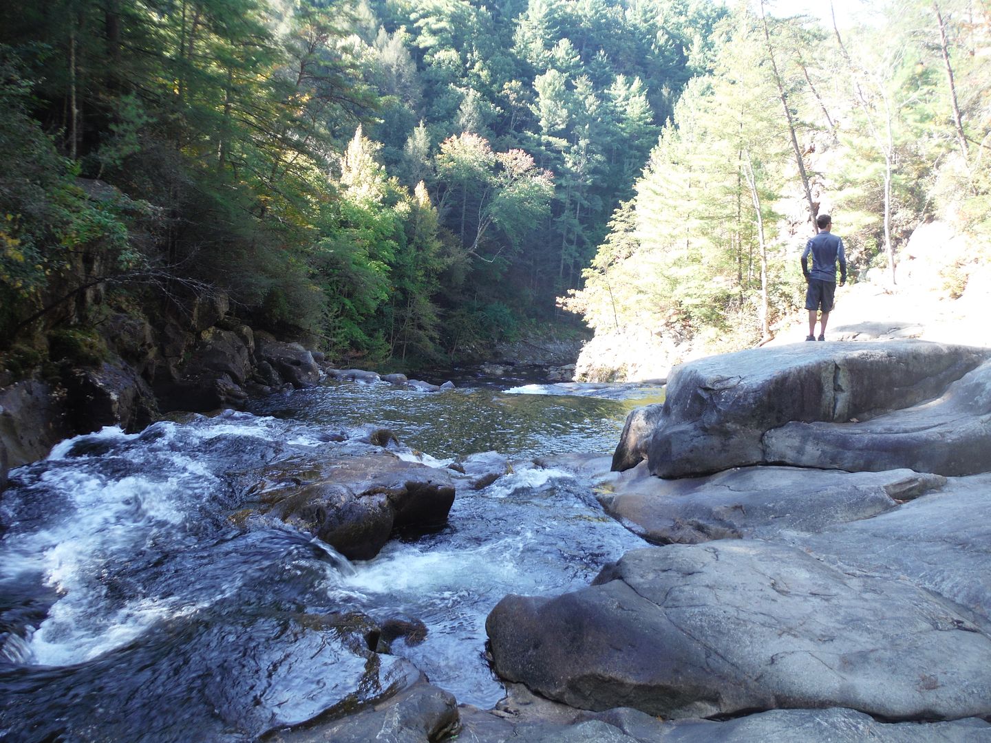
The route: Hickory Creek Trail to Hickory Creek/Conasauga River Trail to Hickory Creek Trail to East Cowpen Trail to Panther Creek Trail to Conasauga River Trail to Hickory Creek/Conasauga River Trail to Hickory Creek Trail and back to the truck. Gear Video  Gear Inventory Part 1 - Preface - Atlanta Exodus It was raining cats and dogs when I left the house around 0730hrs on Friday morning. It had been raining all morning and the forecast was more of the same for our area. I kept watching the radar and saw the line of showers working just below the Chatsworth area. My family made a last ditch effort to persuade me to not go, but I was determined. I went to work and settled up some issues at the shop then went by a couple of stores on the way out of town which meant getting on the interstate around 1300hrs. I made it to Crandall, GA. around 1430 and headed up in to the Cohutta Wilderness. It had stopped raining somewhere around Chatsworth and the area around was damp, but not soaking wet. I parked at the Hickory Creek Trail Head at the intersection of FS17/West Cowpen/FS630. Part 2 - The Cohutta Wilderness - Conasauga River Camp With all the gear already fully packed and nothing else to do, I hoisted up the pack, shot a quick intro video and headed down the trail. My goal was to get across the Conasauga River before sunset and set up a camp. This is roughly 3 miles of trail to the crossing. I crossed Rough Creek and rounded the bend to see a couple of guys camped at the junction of Rough Creek and the Conasauga River. They gave me a couple of pointers on camps and we waved goodbye. The trek up the trail from there was a little soggy and there were a couple of downed trees but not too bad. After passing a lowland swamp, I made it to the junction of the Panther Creek Trail and the Hickory Creek Trail where the Hickory Creek Trail crosses the Conasauga River. It wasn't running hard, but there was no way to rock hop across, so I pulled off the shoes and socks and donned my Tevas and strolled on in. The water was chilly, but not bad. Once on the other side, a quick wipe with the bandanna and I had my socks/shoes back on and was ready to go. The guys at the first camp had told me there were no good sites on the HCT passed the river, so I began looking down my side of the river for an available abode. It turned out that the first spot after the crossing was the best, so I set up there and settled in for the evening. While I was setting up, I notice a fellow hiker across the river and I made contact with him. His name was Lance and he was going to try and head up to Panther Creek Falls tomorrow also. I told him my route and we decided to try and meet up the next evening. He pitched camp across the river and got a fire going. The area around me was littered with downed limbs and dead standing portions of Rhododendron. I made several piles of progressively larger pieces and set a light to my tinder bundle composed of a brown paper bag I found in the parking area and a few shavings from an unknown variety of dead standing tree limb. Although everything was damp, the fire took hold and was easy to maintain. I had prepared a couple of salami and cheese wraps for quick fuel and decided to have one of those for a meal. I downed a liter of water and set about treating another liter for the evening. I used the Potable Aqua and the PA Plus tablets. I'm still here and things are working fine. (grin) My food bag was strung in a tree about 50 yards away and I set down to enjoy the evening. My REI quarter dome 1 tent was a bit cramped for a 6-2 245# fellow, but it worked. I had room for everything. The sleeping pad from Thermarest doubled as a camp seat cushion and extra padding under the sleeping bag. I also used a Nemo Tensor blow up sleeping mat. It was great and I was totally comfortable and warm. I was too warm as a matter of fact. I had to get out of the long underwear and sweater. The low that night was going to be 34 degrees and the next night would be almost 40 degrees. That was when I realized I'd brought to much clothing and would have to carry it with me the whole way. In reality, I was only over packed by the long underwear and one jacket, but that could have easily changed with a minor tweak in the weather. It was okay to have the jacket, but I would leave the long underwear next time. There wasn't much to film the first day. I got a glamour shot of a water crossing at Rough Creek and the Conasauga River, but not much else. I set my camera up to take some shots of the camp set up, but I haven't reviewed that footage yet. I hope it turned out well enough for a time lapse section. The cold took it's toll on my batteries. Of the four I brought, the first one was dead before bed time on day one. Knowing I'd have much more to film, I put the camera away and went to bed. Sometime in the night, I heard a critter rustle the leaves under my vestibule and woke me with a start. It sounded like something taking a big ole sniff of air. I hollered out "Hey Bear" to which nothing responded. Not even a peep. I laughed at myself and went back to bed. The next morning, I collected my gear and hit the trail at around 0730hrs. Part 3 - Hickory Creek Trail aka "The Slog" Within the first mile, I knew I was in for a slog. There was so much dead fall and newly sprouting varieties of trees and briers that the trail was slowly being retaken by the forest. There had been a fire here in 2016 and the whole area was torched. It took me about 4 hours to go 5.5 miles from Hickory Creek Trail to the East Cowpen Trail. Every few yards there was something to go over, under, around or through that made the trail most unpleasant. Many of the multiple creek crossings were choked with dead fall and had to be negotiated delicately to avoid getting wet or just completely circumvented causing much delay and frustration. However, the view of the ridge line across from me was still stunning. The towering height and rolling knobs of the East Cowpen Trail ridge line are truly beautiful. Although, knowing what I was going through here, I couldn't help but think if it was going to be like this up on that ridge where I planned on making my return trip. I just kept on walking. I was concentrating on my footing going up a slight rise when I looked up and saw the bear. I froze in mid stride. I tried to will my heart and breathing to stop. I was slightly off balance and my trekking pole was holding me upright. The bear was pointed off trail with its head in the bushes, seemingly unaware of my appearance. Slowly I righted my position and noticed how oddly skinny the bear seamed. He backed out of the brush and slightly angled his head in my direction. I hollered out "Hey bear!" and his head tilted up sharply. I busted out laughing as I realized I'd improperly ID'd a coon dog. It was the craziest thing. He was black with a brown mussel and looked just like a bear's colors. He waited until I called him down and then trotted over for a head scratching and some good ole back rubbing. He was collared up with two radio tags and his normal collar. I notice there was an address on the collar, so someone was looking out for him. How he found his way so deep in the woods is hard to guess. He must have really been on the trail of something good. Anyway, he followed or led me down the trail to just before the junction at East Cowpen then he bailed off in the woods again and was gone. Part 4 - The High Country of East Cowpen Trail I had filled my canteen and treated the water with tablets earlier on the HCT and I was slowly gaining elevation as I arrived at East Cowpen Trail. I checked the map and saw that I had several more chances to cross high springs or runoff drains, so I wasn't too worried about water. I decided to drink the liter and re-fill on the way up. That wasn't a mistake per se, but I would have done it differently if I'd known that everything above the HCT/ECPT junction was dry as a bone. I gained somewhere around 1500ft in elevation over 2.7 miles to top out on Buckeye Mountain. It would have been nice to have a swig of water up there. As it was, I just kept on plodding. While taking in the view of the valley and the distant ridge line to the East, I started into a nice tight bend in the trail. Now, up to this point I had been calling out in confined areas so that I wouldn't startle any unsuspecting bears. But, this time I had waited a bit longer to begin my call and before the work "Hey B..." got out, all hell broke loose just 15 feet and to right in front of me. The bear went to my right off trail and I went left to the inside wall. He rumbled down the slope grunting and crashing through brush and branch like a loose boulder careening down the mountain. I stepped quickly down the trail grinning from ear to ear. The ridge line of East Cowpen Trail is a gentle up and down mix with great views to the East and West, but like the rest of the area, the trail is being overtaken by new growth and cluttered with deadfall. The briers are especially troublesome in this area. There are large fields of them on either side of the trail for long distances. I continued to call out every so often, but nothing else moved to my sound. I reached the junction of ECPT and the Panther Creek Trail about 1600 hours. Part 5 - Panther Creek Falls - The Alpine Downhill Run Panther Creek Trail trail widened out nicely on what used to be an old logging road double track. It gently sloped down and back to the eastern valley. I was stepping along nicely now. There was not much dead fall or entanglements on this section at all. The gentle slope quickly turned into a zig-zag downhill trail reminiscent of a skier's path down a mountain. What little switchback there was turned into a root and rock stair case that was easy enough to negotiate, but I was still glad to have the trekking poles to ensure a little more balance. The light was changing fast as the sun dipped below the tree line. I pressed on. The trail finally leveled out on a saddle between the hilltops and I could see it dive further into the valley below. There was good evergreen tree cover here and I could see the beginning of a runoff stream to my right. I still couldn't hear water, but I new I was close. I was getting thirsty and my pace was tempered only by the thought of busted legs on a misstep. Once I managed to get down far enough, I heard the first gurgles of running water to my right. I new that would be a refreshing taste, but the light was fading fast and I didn't know how far I had to go exactly. Swallowing hard, I kept on stepping downstream. The trail finally disappeared and after a couple of backtracks I gave up on looking for it and just followed the stream bed, crossing it several times at what looked like some built up spots. I passed into a wetland area and began to see large rock formations on the hill in front of me. I saw clearly, though the trees, an open sky filled with fading sunlight. There was a voice far off to my right and I saw a man on the hill top hanging gear in the trees. I didn't recognize him, so on down the creek I went toward the ever growing opening in the trees. The water was rushing faster and louder with every step. I ascended the boulders to the right of the creek and stepped out on a stage size boulder looking over the valley below. To my left, just a couple of feet away, Panther Creek poured over the ledge and crashed into the boulder field below. The sun was almost below the mountain, but the evening light was enough to revel in the beautiful scene before me. I grabbed a quick video of the area and shot a picture in a text to my wife. She was glad to know that I was alive still. Now it was my turn. I ditched the pack and grabbed the Sawyer Squeeze and went to hydrating like I'd been stuck in the desert for a week. I love that thing! The tablets are great, but that Sawyer gets it done when it needs doing. After a liter or so, I began working on camp. I didn't like the spot I chose, but there were other issues to consider. There were a lot of widow makers in the area. Even my camp had some, but they were less ominous that the others, so here I stayed. At least my floor was flat and dry. It helped that the previous tenants had left enough fire wood and tender size sticks that I didn't even have to leave camp to gather fuel. The wood was wet and needed a lot of attention to finally get going. I used my pocket rocket stove to get the mass blazing. I know, it's cheating, but I was tired and didn't care. I got the tent set up and settled in for a dinner of the remainder of a salami and cheese wrap with trail mix for dessert. I had way over packed food. I still had two breakfast and two entree packs of Mountain House meals, two Cliff Bars and a half a sandwich bag of trail mix. I'd rather eat the fresh stuff, but dehydrated is so much lighter and easier to transport. I'll have to evaluate that for the next trip. In the meantime, the socks and shoes were drying by the fire and it was time to check the map for the last leg of the trip in the morning. I figured I had about 6-7 miles to get out, so an early start was mandatory. The nights rest was awesome. The creek was sloshing gently and there was very little wind. I slept like a log. It was much warmer too. The valley holds the cold and last night was much colder feeling even though it was only a few degrees colder. I had no condensation this night unlike the last night where the rain fly was quite wet on the outside. I had no condensation inside either night. The ventilation in that tent is awesome. I woke at first light and struck camp quickly. I had no idea where the trail was leading down the falls, but intuition and a little human tracking experience soon showed the way. I picked out obvious unnaturally worn areas, broken twigs, smooth worn logs folks had crawled over and many other keys to pick a route off the boulder field. Once at the bottom, the creek crossings began in earnest. The dead fall increased and the Rhododendron began to close back in on the trail. Some of the recently downed trees were absolute monsters. They took out many of their neighbors when they crashed down. One campsite along the path had a good size pine right down the middle. I shivered a little and trudged on. The last two crossings of Panther Creek had me wondering if this was going to get deep. My question was answered just ahead as Panther Creek joined the Conasauga River. Part 6 - The Conasauga River Trail I had to come out of boot and sock again as the water was way to deep to rock hop across. I set up a camera on the pack strap and started to wade the flow. Things were going swimmingly until a rock rolled under my foot. That portion of the video will have some music to accompany the track. (grin) I had finally returned to the Conasauga River Trail which shares the stretch with the Hickory Creek Trail just a couple of miles ahead. I was close to being back where I started. I bore down and pounded out the steps back toward the truck. I was almost back to Rough Creek when I saw Lance having breakfast at his campfire kitchen. I hopped off the trail and settled in to catch up on his trip report. The Sawyer got me ready for the last climb out to the trail head and off I went waving goodbye to another free spirit who loves the woods. See you out there again sometime my friend. Part 7 - The Last Hill I was feeling good and knew I had accomplished my goals for the trip. That gave me plenty of inspiration and momentum to climb the two miles out of the valley and back to the truck. I had experienced some wrong turns and some terrain issues. I had banged my leg on a boulder and it was aching a little, but I met my challenges and had a great deal of confidence that I'd be able to handle pretty much anything if I could just avoid major injury. I reached the truck faster than expected which was great! I went straight into town and aired my tires back up and grabbed a snack. I like a Snickers better than a Cliff Bar, but the Cliff Bars pack and travel better. Soon there after, I was southbound on 411 heading home. Already planning the gear inventory for the next trip. Hope you enjoyed it. For the TLDR folks, here is the Video.  Panther Creek Falls & Hickory Creek Trail. |
|
|
|
[#1]
......
|
|
|
|
[#2]
I will have to get some time to read and review tomorrow. It's been awhile since I've been up to Cohutta. Loved it and it's about as remote as you can get in the SE.
ROCK6 |
|
|
|
[#3]
My backyard. Live on Ft. Mountain. Was on the Emery Creek Trail yesterday for an easy 10 miler. Anyone going out into the Wilderness want a hiking partner, hit me up.
|
|
|
|
[#4]
Had a chance to read it all...well written; thanks for taking the time.
I read you comment on food and laughed. We have "over packed" food in the past. It wasn't until my wife and I started hitting 5-6 days on the trail that we realized the first few days, we just don't eat as much. Not sure if it's the stress to the body, environment change, or just the excitement of getting on the trail that keeps the appetite at bay. At day three or four, we really start consuming everything planned. We've been much better at calculating food to where we are spot on with may a little extra snack left over which can be added to the next day. The last time we were up there was a few yeas ago (2014/15?), and it was during bears season. We pulled up to a parking area and trailhead where we hiked in from the East Cowpen trail to Hickory Ridge trail. We then hiked back up Jacks River to the Rough Ridge trail to complete the loop back out. Ironically as we pulled in to part early that first morning, a group of "kids" were sitting around the early morning fire and warned us about the bear they shot the previous night and lost when tracking...gee thanks guys  I think all told with some side trail excursions, we did about 26 miles. I love it, but my wife didn't care for the hike in very much. Even back then the trails were pretty cluttered with debris and downfalls. We also ran into about 8-9 other hikers and small groups (2-3). Everyone of them were open carrying...which I thought was cool. I think all told with some side trail excursions, we did about 26 miles. I love it, but my wife didn't care for the hike in very much. Even back then the trails were pretty cluttered with debris and downfalls. We also ran into about 8-9 other hikers and small groups (2-3). Everyone of them were open carrying...which I thought was cool.Again, I really like the area as it's about the largest "remote" backpacking areas in the SE. There are a lot of other trails and loops to explore, and the river crossings are nice in the later summer swelter! 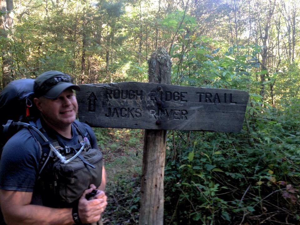
Again, it's surprising how much debris was in the falls! There was almost no debris when we were there last and it was beautiful! 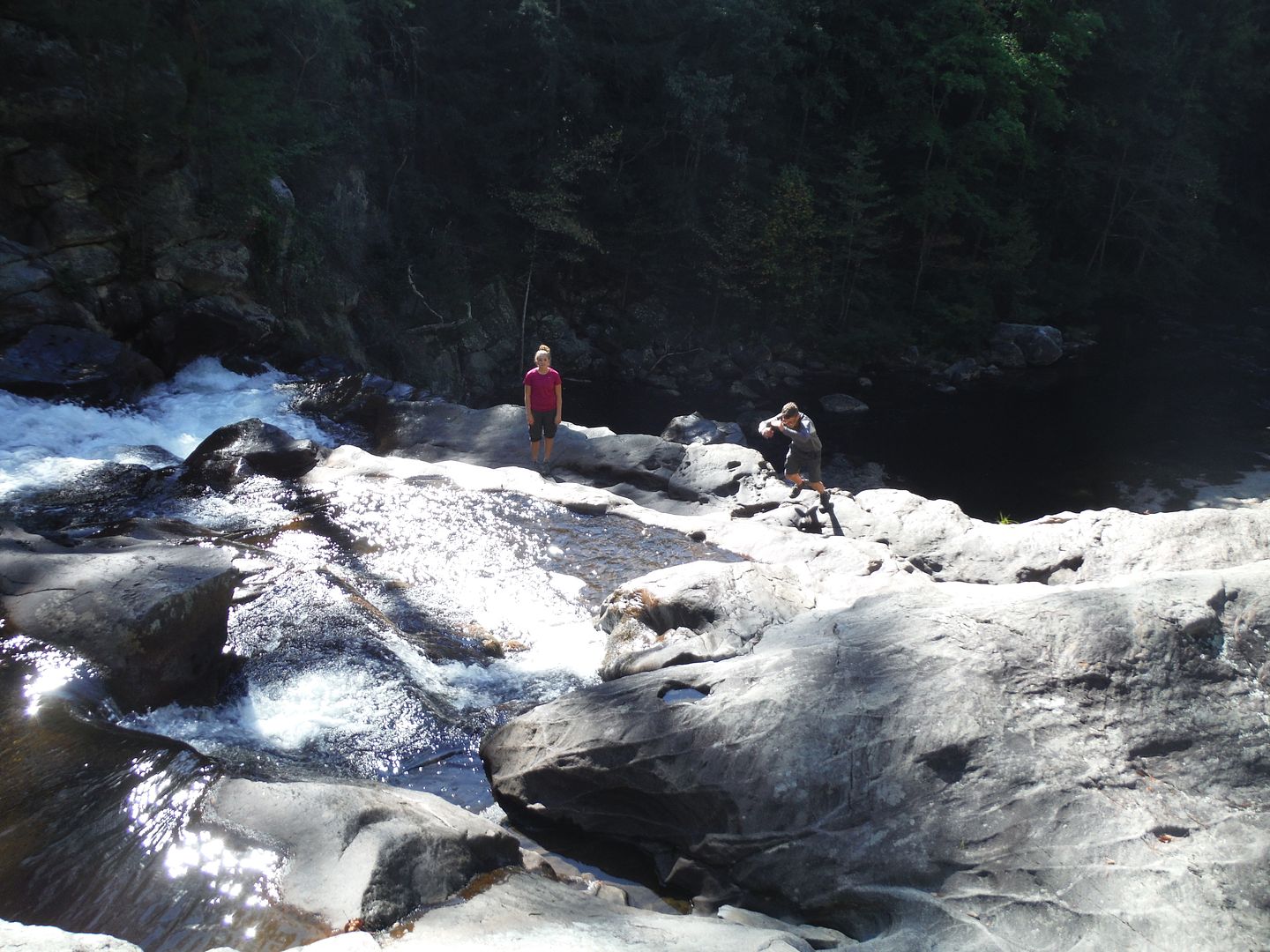
ROCK6 |
|
|
|
[#5]
Nice pictures @ROCK6
We did the Beach Bottom Trail to the Jacks River Falls back in early November. I'll post a link to the video below. It had been raining everyday the week we went so the water was way up. I'll post up next time I'm planning on going that way. I've got to get some training in. I'm planning to do the Georgia to North Carolina section of the AT in March/April. It's still in the planning stages. Anyway, to the video.  Jacks River Falls |
|
|
|
[#6]
Quoted:
My backyard. Live on Ft. Mountain. Was on the Emery Creek Trail yesterday for an easy 10 miler. Anyone going out into the Wilderness want a hiking partner, hit me up. I'll post a new thread and send a PM when I get an idea when I can get that way again. |
|
|
|
[#7]
Great. Look forward to meeting more ARFcommers.
|
|
|
|
[#8]
Quoted:
I'll post up next time I'm planning on going that way. I've got to get some training in. I'm planning to do the Georgia to North Carolina section of the AT in March/April. It's still in the planning stages. Very cool thanks! I was trying to figure out if you came in from the north or south. We hiked in from the south. There are a ton of trails in and around that area! Yeah, my wife and I have section hiked up to VA on the AT. When I got home from A'Stan in March, wanted to try a 100 miles, unsupported on the AT. I went from Neel's Gap to the NOC (or Wesser Gap). It was 106 miles and took me 7 days and a wake up...it's a great section to really test you out. There are a couple places to do a resupply so you don't kill yourself trying to prove something like I did It's definitely worth the effort...
ROCK6 |
|
|
|
[#9]
Nice write up. Sounds like a great test trip.
Think I may need to do this myself. |
|
|
|
[#10]
@TxLewis
@ROCK6 @JSB2k10 Anyone up for an overnighter or two in the Cohutta? Route/Trails to be picked once we determine the date and time frame. December 27, 28 and 29 Friday to Sunday out by 12PM on Sunday |
|
|
|
[#11]
Quoted:
@TxLewis @ROCK6 @JSB2k10 Anyone up for an overnighter or two in the Cohutta? Route/Trails to be picked once we determine the date and time frame. December 27, 28 and 29 Friday to Sunday out by 12PM on Sunday I wouldn't mind doing a trip up there later in the spring/summer though... ROCK6 |
|
|
|
[#12]
Quoted: I'm stuck up in VA until February-March...can't do Cohutta, but will do some Shenandoah I wouldn't mind doing a trip up there later in the spring/summer though... ROCK6 Spring/Summer sounds good. Lots of river crossings to keep cool in. |
|
|
|
[#13]
My middle child and I hiked some of that same area many years ago and went to Pather Creek Falls as well. We came up from the south and it was a pretty strenuous hike and we carried way too much gear. Good times. Probably my favorite memory of my son and I together. Oh, and a bad thunderstorm came through while we were at the trailhead leading down to the falls that evening after we went to the falls. Hail and then high winds all night. Kept listening for tornadoes but the wind was too loud so we just held on and prayed, literally. Too far from the car to try and make it in the dark.
jd1 |
|
|
|
[#14]
Quoted:
My middle child and I hiked some of that same area many years ago and went to Pather Creek Falls as well. We came up from the south and it was a pretty strenuous hike and we carried way too much gear. Good times. Probably my favorite memory of my son and I together. Oh, and a bad thunderstorm came through while we were at the trailhead leading down to the falls that evening after we went to the falls. Hail and then high winds all night. Kept listening for tornadoes but the wind was too loud so we just held on and prayed, literally. Too far from the car to try and make it in the dark. jd1 |
|
|
|
[#15]
So, I've decided to hike the Georgia Section of the Appalachian Trail. I'm going to take a week in March and see if I can get it done. I'm going for 6 days 5 nights which will be an average of around 15 miles a day. I've already done the approach trail and hike inn trail loop which is about 12.3 miles. It was a workout, but not anything super hard. That video can be found here AT Approach & Hike Inn Loop Trails
Here is the load out that I'm currently training with. Lighterpack Gear List I do several hikes a week, varying the distance and terrain. I'm currently battling a bit of Plantar fasciitis, but I've been there before. It'll go away. The closer I get to zero day, I'm going to concentrate on hills. I'm mixing in Pine Mountain, Kennesaw Mountain and some smaller hills in my neighborhood. I'm going to do a good 15 miler tomorrow up near John's Mountain NW GA area. |
|
|
|
[#16]
I hiked that area 15 years ago. It’s beautiful country. See any bigfeet? I had somewhat of an encounter when I was there in 2005.
|
|
|
|
[#17]
Quoted:
I hiked that area 15 years ago. It's beautiful country. See any bigfeet? I had somewhat of an encounter when I was there in 2005. |
|
|
|
[#18]
Quoted:
So, I've decided to hike the Georgia Section of the Appalachian Trail. I'm going to take a week in March and see if I can get it done. I'm going for 6 days 5 nights which will be an average of around 15 miles a day. I've already done the approach trail and hike inn trail loop which is about 12.3 miles. It was a workout, but not anything super hard. That video can be found here AT Approach & Hike Inn Loop Trails Here is the load out that I'm currently training with. Lighterpack Gear List I do several hikes a week, varying the distance and terrain. I'm currently battling a bit of Plantar fasciitis, but I've been there before. It'll go away. The closer I get to zero day, I'm going to concentrate on hills. I'm mixing in Pine Mountain, Kennesaw Mountain and some smaller hills in my neighborhood. I'm going to do a good 15 miler tomorrow up near John's Mountain NW GA area. The biggest challenge was no resupply. I carried 9 days of food and fuel. My pack weight was about 10 pounds heavier than normal, but this was more of a gut-check for a bug-home test... ROCK6 |
|
|
|
[#19]
Quoted: That's doable. I did the 106 miles from Neels Gap to Wesser Gap (NC)/NOC. I planned for 9 days and did it in 7 and a wake up. I meant to only do about 10-12 miles the first few days, but quickly picked it up. Made my best daily distance on day 6, doing just over 22 miles. Not sure I could sustain that, but the next morning was only 6 miles, so I was pushing it The biggest challenge was no resupply. I carried 9 days of food and fuel. My pack weight was about 10 pounds heavier than normal, but this was more of a gut-check for a bug-home test... ROCK6 |
|
|
|
[#20]
Quoted:
What mix of food did you carry? Sounds like a lot of fresh items instead of dehydrated meals, amiright? I also do a chocolate nut butter and tortilla wrap for lunch, along with various granola, energy bars, a little trail mix, nuts, etc. to snack on. Breakfast is usually on the go, but I do have a few instant coffee mixes I’ll sometimes burn extra fuel to have. I would have dig up my weights, but I want to say my 8.5 day meal plan was about 11-12 pounds total, but I did end up with a day and half’s worth of food when I finished. The key is really to calculate enough to keep the calories coming in as you’re burning them. It has taken a few trips to find that balance of having just enough, maybe a little extra instead of packing out an additional five pounds of food. I met my wife halfway through her 120 mile trek and brought resupplies…it was way too much and we offloaded a bunch to a group of church kids hiking the same route. There's a vast difference between what I would take for "camping" vice backpacking. However, on longer trips where we have a supply pick up, we will often front load the first meal with some fresher food, fruit, nice deserts and a soft flask of wine ROCK6 |
|
|
|
[#21]
@TxLewis
@ROCK6 @JSB2k10 @Mazawakhan The training continues. I'm doing 10 to 12 milers every weekend and shorter ones every couple of days. The legs are feeling okay. I have just a bit of trouble with my left knee now. I had to have a Cortisone shot in my heals so the spurs would calm down. This is going to be an adventure for sure. I shot a quick video of Pigeon Hill at the Kennesaw Mountain National Battlefield Park. This is the warm up hill to Little Kennesaw and then on to Big Kennesaw. I start at Cheatham Hill Road parking area and hike to the Visitor's Center and back. The route is 11.5 miles total. I'm going over the mountains twice. The downhill on Little K is a beast. Maybe I'll shoot some video of that scramble too. Anyway, just giving an update. I'm heading out at the end of March. I don't know if I'll post from the trail or not. I'll have to see what the weather and reception are like once I get to camp each night. Alright, that's it for now. Thanks for looking in.  Kennesaw Mountain - Pigeon Hill Scramble |
|
|
|
[#22]
Thanks for the update OP
|
|
|
|
[#23]
Good work. Steady regular mountain rucking is great. I slacked off over the winter. Back to it now.
|
|
|
|
[#24]
There have been some folks over in the Ga hometown forum trying to get a battle buddies thing going.
I'm semi retired and have tons of time off if anyone wants to do some 1, 2, 3 or more days hikes. For a week, Duncan Ridge trail is a good one. It's a loop which makes logistics easier, and it's about 70 miles or so. So depending on hiking speed (parts of the trail are fairly strenuous) it can be done in 4-7 days according. My wife is going on a cruise April 17th, so that would be a good time to plan a 2-3 day trip. Meanwhile, day hikes are good anytime. Anyone? Bueller? |
|
|
|
[#25]
Quoted:
There have been some folks over in the Ga hometown forum trying to get a battle buddies thing going. I'm semi retired and have tons of time off if anyone wants to do some 1, 2, 3 or more days hikes. For a week, Duncan Ridge trail is a good one. It's a loop which makes logistics easier, and it's about 70 miles or so. So depending on hiking speed (parts of the trail are fairly strenuous) it can be done in 4-7 days according. My wife is going on a cruise April 17th, so that would be a good time to plan a 2-3 day trip. Meanwhile, day hikes are good anytime. Anyone? Bueller? I know @JSB2k10 would be up for a run through the Cohutta Wilderness if that is an option. Just throwing out ideas.... |
|
|
|
[#26]
Quoted:
I don't know if I'll post from the trail or not. I'll have to see what the weather and reception are like once I get to camp each night. Alright, that's it for now. Thanks for looking in. Quoted:
I'm semi retired and have tons of time off if anyone wants to do some 1, 2, 3 or more days hikes. For a week, Duncan Ridge trail is a good one. It's a loop which makes logistics easier, and it's about 70 miles or so. So depending on hiking speed (parts of the trail are fairly strenuous) it can be done in 4-7 days according. ROCK6 |
|
|
|
[#27]
Duncan Ridge loop starts on Benton McKay trail, takes Duncan Ridge back east over to AT for the loop back to Springer. Benton McKay is a lot less travelled than AT, Duncan Ridge is rarely used. Last time I hiked it, the trail was barely noticeable.
We can plan it later this Spring if you're interested. No rush. Only big problem with Duncan Ridge is generally it's pretty dry. Probably not a problem now. |
|
|
|
[#28]
Rice Camp Trail to Jacks river is one of my favorite trails. There is a great camping spot tucked away that we always use. I have had some "weird" experiences while in that area though. Nevertheless beautiful country and challenging trail.
|
|
|
|
[#29]
I'm up for a 2-3 day hike starting sometime in mid-late April. Preferably during the week when normal folk are working.
|
|
|
|
[#30]
Quoted:
I'm up for a 2-3 day hike starting sometime in mid-late April. Preferably during the week when normal folk are working. I'll do a litle thinking and come back with some ideas. In the meantime, we could do a day hike and get acquainted. Maybe even get a few others to join in. |
|
|
|
[#31]
Quoted:
That sounds good to me. Let's start brainstorming some routes. Loops are best, and I can do 15-16 miles a day no problem. (less or more is fine, just trying to give an idea) I'll do a litle thinking and come back with some ideas. In the meantime, we could do a day hike and get acquainted. Maybe even get a few others to join in. Quoted:
Quoted:
I'm up for a 2-3 day hike starting sometime in mid-late April. Preferably during the week when normal folk are working. I'll do a litle thinking and come back with some ideas. In the meantime, we could do a day hike and get acquainted. Maybe even get a few others to join in. |
|
|
|
[#32]
The Appalachian Trail Conservancy asks you to postpone your hike.
Yep, one week out from kickoff. This crap is out of control. Maybe the trail will be less crowded. 
|
|
|
|
[#33]
Quoted:
The Appalachian Trail Conservancy asks you to postpone your hike. Yep, one week out from kickoff. This crap is out of control. Maybe the trail will be less crowded. ROCK6 |
|
|
|
[#34]
I planned to do that for the most part anyway. Shelter in place and/or Martial Law orders are a concern though. Atlanta Metro is slowly shutting down. If we make it to next week without some degree of a government ordered quarantine, I'll be surprised.
|
|
|
|
[#35]
There ain't no martial law out in the woods. I went for an 8 mile hike yesterday with the pooch. Didn't see another soul. Not many people in the road either.
|
|
|
|
[#36]
Just for grins, MrsSpark and I did the Homestead loop at Red Top this evening. There were a few people, but not a lot. I didn't see any obvious signs of impending closures or other issues. It was business as usual. There were actually a tonne of boaters out on the lake today. Looks like a good time was had by all.
I'm still getting ready to go....
|
|
|
|
[#37]
Well,
They closed the State Parks. The ATC has shut down the trail. My County just issued a State of Emergency. All the counties around have Shelter in Place orders. I think I'm going to have to push this back a day or two (wink wink) until all this blows over. I'm just glad I didn't spend money on travel and lodging. I know there were a bunch of folks who did and are fighting to get things re-arranged or canceled now. Oh well, I'll keep training and losing weight. It'll be even easier when i do get to go. To be continued...... Y'all stay safe and healthy. |
|
|
|
[#38]
So we've had this day off planned for months now. We stayed on plan and left this morning for Amicalola Falls State Park. The Visitor's Center and restrooms at the Approach trail head were closed, but the rest of the park was open. We climbed the 700+ steps to the top of the falls and took the East rim trail back down. On the way down I met a young European fellow who had made arrangements to be here today and start the trail. He was visibly worried and unsure of what he was doing. He said, "I hope there are others out there."
I purposely left my gear at home, so I wouldn't be tempted to jump on the trail and go. I wanted to run home and get my stuff and get out there just so he wouldn't be alone. I know most of the youtubers are off the trail now. Who knows who is solo hiking with no vlog, but maybe there are some. We ate lunch in the park and watched the folks fish in the trout pond with little success. The ride home went through Ellijay, Georgia and the multitude of Apple Orchard road side stores. All were closed but one. We loaded up on apples, vidalia onion hot sauce and muscadine juice. Here I sit thinking of my European friend out there tonight and I'm hoping he's doing well. I guess I'll go do yard work tomorrow and go see Mom. 87 degress in Georgia in March...Yellow pollen flowing like a sand storm....It's gonna be a hot summer. Melancholy....blues... |
|
|
|
[#39]
I had a very long post ready to go about Mom, and my dog...no trains, but it would have made a passable country and western song if someone cared to listen. I went to get the video and lost the whole thing in screen transition. Y'all pray for Mom and the dog. It's a good thing I'm still home.
Thanks for watching. I guess I have lost the ability to embed videos. Maybe a link? Amicalola Falls 3.27.20 |
|
|
|
[#40]
Quoted: Melancholy....blues... I hear ya. I just came down for a week of telework as our planned move from VA down to GA isn't scheduled until the latter part of April. I have to go back up next weekend and hoping I can convince them to let me move early so I can do the "14-day quarantine" in GA before in-processing with the new facility. I do hope it's a hot summer to burn this crud out and get the trails opened back up! Stay safe, ROCK6 |
|
|
 Win a FREE Membership!
Sign up for the ARFCOM weekly newsletter and be entered to win a free ARFCOM membership. One new winner* is announced every week!
You will receive an email every Friday morning featuring the latest chatter from the hottest topics, breaking news surrounding legislation, as well as exclusive deals only available to ARFCOM email subscribers.

AR15.COM is the world's largest firearm community and is a gathering place for firearm enthusiasts of all types.
From hunters and military members, to competition shooters and general firearm enthusiasts, we welcome anyone who values and respects the way of the firearm.

Subscribe to our monthly Newsletter to receive firearm news, product discounts from your favorite Industry Partners, and more.
Copyright © 1996-2024 AR15.COM LLC. All Rights Reserved.
Any use of this content without express written consent is prohibited.
AR15.Com reserves the right to overwrite or replace any affiliate, commercial, or monetizable links, posted by users, with our own.