|
[#1]
There are some bunkers up on the other side of Otay Mountain:
http://abnf.co/CA-wwii_bunker_otay_mountain.htm It has been over ten years since I went up there. Was planning to drive up there again soon to look around. There also have been a few airplanes that crashed into it. |
|
|
|
[#2]
Quoted: You mean the lot below SBRGC I assume? Even if the trail starts farther up we could carpool form there for those with sedans. I rode it yesterday, and unless your car is very low, it can make it. just how slow you want to go is the issue |
|
|
|
[#3]
If we were to open-carry, the actual hike and arming-up would need to begin and stay off of any official roads, as discharge is prohibited on or across all such roads (and therefore carry on them other than CCW w/permit and a couple of other limited exceptions is illegal).
|
|
|
|
[#4]
Quoted:
If we were to open-carry, the actual hike and arming-up would need to begin and stay off of any official roads, as discharge is prohibited on or across all such roads (and therefore carry on them other than CCW w/permit and a couple of other limited exceptions is illegal). As you can see, it is a bunch of jeep roads in the area, and a few named roads. Note that the gps location Maggiethecat first provided is at the junction of Danahue Spur Road and Cottonwood Creek Road. There is a locked gate at that junction so people often park at that point and walk in to shoot, carrying their shooting gear. There is a sign with shooting rules at that junction. If you take a longer route you can drive to all the shooting locations I indicated on the map. There isn't much in the way of foot trails. Much of the area is heavy brush. |
|
|
|
[#5]
If people regularly shoot or carry guns in those areas, I don't foresee a problem. I'm just thinking about travel from the parking lot mentioned by the range to wherever we want to begin the hike. Carpool to a spot off of the main/paved roads from the parking lot as mentioned earlier would probably be the best bet.
|
|
|
|
[#6]
Google Maps link for trailhead/rendezvous point for 2/23 San Dimas hike:
https://www.google.com/maps/place/Michael+D.+Antonovich+Trail/@34.0910849,-117.8226384,518m/data=!3m2!1e3!4b1!4m5!3m4!1s0x80c32f281a595add:0x4cc0a045b4ca045b!8m2!3d34.0910849!4d-117.8204443 |
|
|
|
[#7]
Quoted:
If people regularly shoot or carry guns in those areas, I don't foresee a problem. I'm just thinking about travel from the parking lot mentioned by the range to wherever we want to begin the hike. Carpool to a spot off of the main/paved roads from the parking lot as mentioned earlier would probably be the best bet. |
|
|
|
[#8]
Did a preliminary hike at the San Dimas location to test the waters there. I've never hiked past a certain point, and never with a ruck. I've got it figured out how I'd want to do it. Kicked my ass, though, which just means I need to do it again. Did it with a 46-lb. ruck, dry weight. With water it was about 56 lbs. I learned that something's off in the way it's adjusted. Not sure what's out of whack, as it was fine previously. Hip belt, no matter how much it was cinched down, did not want to stay in place, and kept getting pushed down, shifting the weight to my upper back and shoulders. I'll post pictures of the trail tomorrow, but there are definitely spots where you have to be really careful and not try to go too fast. The steep ascent at the end sucked, though. On the trail itself I did 6.3 miles, but there's a loop that can be cut out that gets it down to 6.
This was the pack I used today. I didn't load it up entirely like I was actually going to use the contents, but I think it simulated the weight decently. 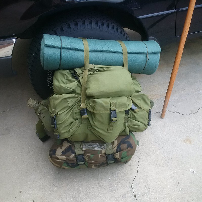

|
|
|
|
[#9]
You need more water.
I've never used one of those packs. With the back packs I've used, you want the weight up high. Move the blue pad to the bottom and the sleeping sack up to the top. Seriously, you need more water. |
|
|
|
[#10]
I brought along 5 quarts of water. I drank maybe three.
|
|
|
|
[#11]
Quoted: I'm also near Pomona and am watching this thread with interest. 
|
|
|
|
[#12]
Yes, but you only hiked 6 miles. You were not out overnight or on a multi-day hike. Potable water, or lack thereof, is a real issue here in the desert West.
|
|
|
|
[#13]
Quoted:
Yes, but you only hiked 6 miles. You were not out overnight or on a multi-day hike. Potable water, or lack thereof, is a real issue here in the desert West. go elsewhere. |
|
|
|
[#14]
I'm interested. I shoot out there in the hills past South Bay. Is the plan just to hike with a rifle or are you going to hike to a certain spot, target shoot then hike back?
I've also been looking online and can't find anything that says it's illegal to shoot in the dark out there on BLM land. I've been wanting to set up some steel, and shoot it in the dark since the sun sets so early still. I was thinking it would be cool to tape glow sticks to the steel then hit them from distance. |
|
|
|
[#15]
Quoted:
I'm interested. I shoot out there in the hills past South Bay. Is the plan just to hike with a rifle or are you going to hike to a certain spot, target shoot then hike back? I've also been looking online and can't find anything that says it's illegal to shoot in the dark out there on BLM land. I've been wanting to set up some steel, and shoot it in the dark since the sun sets so early still. I was thinking it would be cool to tape glow sticks to the steel then hit them from distance. Right now I'm thinking we hike in and out (I still need to figure out a course; it's been busy the last few days, though) and if we shoot, we shoot after the hike is complete. I'll defer to those with local knowledge about the best places to set up for shooting. |
|
|
|
[#16]
Here is a potential trail loop:
5.56 miles. LOL. Note I just found the distance using my curser, the real trail would be longer. |
|
|
|
[#17]
Quoted: I've never seen a nighttime BLM shooting restriction. If it's legal to shoot, it's legal to shoot at any time. I've shot at night on BLM land out in the desert. Right now I'm thinking we hike in and out (I still need to figure out a course; it's been busy the last few days, though) and if we shoot, we shoot after the hike is complete. I'll defer to those with local knowledge about the best places to set up for shooting. |
|
|
|
[#18]
If anyone is interested I have property in AZ next to BLM land and you can shoot hike whatever.
|
|
|
|
[#19]
I apologize for not having posted in a while, but it's been a really busy week and I'm out of state on a job. Anyhow, I wanted to post pictures of the Walnut Creek area for those interested in that hike. Some pictures are from an earlier hike, but the area largely looks the same right now. Pictures of the creek are spots where it needs to be crossed. Some can be a bit tricky. Just something to watch out for. Some storms also felled some trees and large branches onto or near the trail, but nothing impassable.


|
|
|
|
[#20]
I hate to do this, but the job I'm on in Arizona got extended a few days, so there's no way I'll be able to lead a hike on the 22nd as planned. If those interested are amenable to it, I'd like to reschedule the hike for two weeks later (after the planned San Diego area hike), which would be Saturday, March 7th, same time and place. Any objections?
|
|
|
|
[#21]
I'm interested but I'll have to wait a bit. I messed up my back working around the house last weekend.

|
|
|
|
[#22]
If time permits , l would be in on this.
It would be good to meet some of the Cali ARF crew. |
|
|
|
[#23]
Went shooting in the location near Engineer Springs today. Quite a few shooters and off roaders around today, and a Marine helicopter flew low over us. The wild lilac is blooming and parts of the hills are purple.
Note that there is a sign that says to not shoot steel targets. People shoot steel targets anyway, but you want to be careful about fire. Are we still on for the 29th? |
|
|
|
[#24]
Quoted:
Went shooting in the location near Engineer Springs today. Quite a few shooters and off roaders around today, and a Marine helicopter flew low over us. The wild lilac is blooming and parts of the hills are purple. Note that there is a sign that says to not shoot steel targets. People shoot steel targets anyway, but you want to be careful about fire. Are we still on for the 29th? |
|
|
|
[#25]
Quoted:
Went shooting in the location near Engineer Springs today. Quite a few shooters and off roaders around today, and a Marine helicopter flew low over us. The wild lilac is blooming and parts of the hills are purple. Note that there is a sign that says to not shoot steel targets. People shoot steel targets anyway, but you want to be careful about fire. Are we still on for the 29th? |
|
|
|
[#26]
Quoted: Did you take a photo of the sign? Are you sure it didn't say don't shoot steel ammo? It said don’t shoot rocks or metal or use steel ammunition. I made a point to look at that since I remembered that was the case. People were shooting steel targets anyway. |
|
|
|
[#27]
Quoted:
No, I didn’t. It said don’t shoot rocks or metal or use steel ammunition. I made a point to look at that since I remembered that was the case. People were shooting steel targets anyway. Quoted:
Quoted: Did you take a photo of the sign? Are you sure it didn't say don't shoot steel ammo? It said don’t shoot rocks or metal or use steel ammunition. I made a point to look at that since I remembered that was the case. People were shooting steel targets anyway. |
|
|
|
[#28]
Alright, so the hike for 2/29 at Engineer Springs is still on. Meeting point will be the parking lot below SBRGC mentioned earlier with a carpool to the point at which the hike will commence. We'll do the loop drawn out by DonS and if circumstances permit, do some shooting. We will attempt to make the 3mph average pace, but I'd rather we stick together than split up, so if that means we don't make it this time, so be it. I'll see if I can get a map of the area to use for the hike and mark out the loop on it. If you decide to bring a ruck, 25 lbs. dry weight to attempt to qualify for provisional Battle Buddy status, 35 lbs. + rifle or 45 lbs. without a rifle, with LBE and PCs not counting toward weight, to attempt to qualify for 3rd Class. This will be an open carry hike, so it'd be nice to see attendees coming with a rifle and maybe some minimal LBE at least, even if a ruck is not brought. Obviously, water and some trail snacks plus the rest of the outdoor essentials highly recommended.
For shooting, I'd recommend bringing portable target stands and targets, at the very least. We should try to get some decent photos, too. The one thing I'm still contemplating is the meeting time. I'd like to start sometime in the morning, but also want to be mindful for anyone who wants to come who is coming from the LA area or further out. I'm thinking 1030 would be a good time. For now I'll provisionally make that the meeting time, but if anyone has input on that, it is welcome. I'll add a couple more details later today, but for now I'd like to get a head count of those who plan to attend. Also, there is a hike in the LA area planned for 1030, 3/7, at the head of the Mike Antonovich trail in San Dimas. The lot at the trail head is on San Dimas Ave., between the 57 Fwy. and Loma Vista Ave., on the southbound side of the road. This will be a 6-mile hike. Other than CCW with a permit, no firearms for this hike. 25lbs. and 45lbs. dry weight to qualify for Provisional or 3rd Class Battle Buddy if we make pace for those so inclined. As above, water and other outdoor essentials highly recommended. So far we have two from Calguns planning on coming plus myself. If anyone else is interested, I'd like to get a head count for this one as well. @ for locals or those who have previously expressed interest in either hike or BB generally: @DonS @HDLS @maggiethecat @Chukar @spearogun @Busaboy2009 @bajagringo @slappomatt @Avila33 @Polerouter @50_Shooter @Paul @codzilla |
|
|
|
[#29]
Wife is in town, which is a rarity, so I'm out of this one
|
|
|
|
[#30]
Quoted:
If anyone is interested I have property in AZ next to BLM land and you can shoot hike whatever. |
|
|
|
[#31]
Have a good hike Cali bros
...
|
|
|
|
[#32]
@bigstick61
Weren't you were going to Calico with the Webshooters, years ago? |
|
|
|
[#33]
@bigstick61
Thanks for putting all this together. Count me in for the San Dimas hike. |
|
|
|
[#34]
Quoted:
@bigstick61 Weren't you were going to Calico with the Webshooters, years ago? |
|
|
|
[#35]
I plan to be there.
|
|
|
|
[#36]
Quoted:
I plan to be there. |
|
|
|
[#37]
So I was looking at the image of the area from Google Maps and it looks like there's a trailhead closer to the parking lot by the gun range that takes you to the same trail loop. I think that would be the better point from which to begin the hike itself after we meet.
@DonS Would the lot pinned here be the one to which you're referring, just for confirmation? 
|
|
|
|
[#38]
That's probably the lot he means.
and the trail head isnt a trail head. I've never seen a trail there. It's a wide graded gravel road, with some steep and some gradual elevation changes. |
|
|
|
[#39]
Quoted:
That's probably the lot he means. and the trail head isnt a trail head. I've never seen a trail there. It's a wide graded gravel road, with some steep and some gradual elevation changes. |
|
|
|
[#40]
Can't make it guys
I got back in yesterday and need to be in tomorrow. Boss wouldn't like it if I took off the first week being here. |
|
|
|
[#41]
Quoted:
So I was looking at the image of the area from Google Maps and it looks like there's a trailhead closer to the parking lot by the gun range that takes you to the same trail loop. I think that would be the better point from which to begin the hike itself after we meet. @DonS Would the lot pinned here be the one to which you're referring, just for confirmation? https://live.staticflickr.com/65535/49594107947_a612cf7624_b.jpg The "trailhead" is just a "T" in the road. It is where the jeep trail that goes over Otay Mtn breaks off from Marron Valley Road. The Jeep trail might not be legal to carry on (although I know people do shoot off it at times since I've picked up their brass). |
|
|
|
[#42]
Quoted: It does look grey on the satellite image. We'll stick to the originally proposed start-off point, then. I'm working on putting together a map. Some of those trails do not appear on the topo maps of the area. |
|
|
|
[#43]
I plan on leaving my area around 0730-0745 just to be safe (not sure what traffic will be like, although I doubt it'll be too bad, or transit time, but it'll definitely take me over two hours to get there). 1030 meeting at the lot. We'll start prepping to move to the starting point around 1045 barring any delays, to give some time for unannounced latecomers or someone showing up who hasn't said they're coming in advance. I'll PM for phone number exchanges shortly so that we can coordinate and notify if any of us are running a bit late for any reason.
It's not supposed to rain until the evening, but be prepared just in case (rain gear should be part of the outdoor essentials being brought, anyways). Just a reminder that this is an open carry rifle hike, so that is encouraged. So far we have two confirmed including myself, and one highly probable. If this are looks good, we may end up doing another hike there in the not-too-distant future (and I think we might get a bit better turnout from the locals; I know some folks wanted to come to this one but could not). If anyone else is in for this hike, please let me know ASAP. I'll check my PMs and this thread really quickly in the morning, and will check a couple of times this evening. |
|
|
|
[#44]
I can't make it.
Have fun |
|
|
|
[#45]
Quoted:
I apologize for not having posted in a while, but it's been a really busy week and I'm out of state on a job. Anyhow, I wanted to post pictures of the Walnut Creek area for those interested in that hike. Some pictures are from an earlier hike, but the area largely looks the same right now. Pictures of the creek are spots where it needs to be crossed. Some can be a bit tricky. Just something to watch out for. Some storms also felled some trees and large branches onto or near the trail, but nothing impassable. https://live.staticflickr.com/65535/49480869021_d330f245e6_c.jpg https://live.staticflickr.com/65535/49480868986_bf977c7e04_c.jpg https://live.staticflickr.com/65535/49480388618_37b00031e1_c.jpg https://live.staticflickr.com/65535/49527703353_1a26cf622b_c.jpg https://live.staticflickr.com/65535/49528211136_c15068d4f3_c.jpg https://live.staticflickr.com/65535/49528437977_32b9bd09c7_c.jpg https://live.staticflickr.com/65535/49527703058_c519a4789b_c.jpg https://live.staticflickr.com/65535/49528211801_0fd5f853f3_c.jpg https://live.staticflickr.com/65535/49528438567_a8d4160b59_c.jpg |
|
|
|
[#46]
Quoted:
Watch out for poison oak in the riparian areas and nearby woods! DonS and I completed our first SCBB hike today. IIRC, it ended up being closer to 8.2 miles. I'll post more later (probably sometime tomorrow) including pictures. |
|
|
|
[#47]
|
|
|
|
[#48]
Quoted: https://www.AR15.Com/media/mediaFiles/2813/IMG_1308_jpg-1297933.JPG https://www.AR15.Com/media/mediaFiles/2813/IMG_1310_jpg-1297934.JPG https://www.AR15.Com/media/mediaFiles/2813/IMG_1311_jpg-1297936.JPG https://www.AR15.Com/media/mediaFiles/2813/IMG_1312_jpg-1297937.JPG https://www.AR15.Com/media/mediaFiles/2813/IMG_1313_jpg-1297938.JPG
Nice, I was on the job today, and unpacking... Hopefully we'll get together |
|
|
|
[#49]
Added some text to the pictures to show landmarks:
The part of the loop nearest Mexico was 3.73 miles from Mexico. After we completed the loop, we heard an illegal calling out from someplace to our west (in what sounded like distress). We contacted BP via 911. |
|
|
|
[#50]
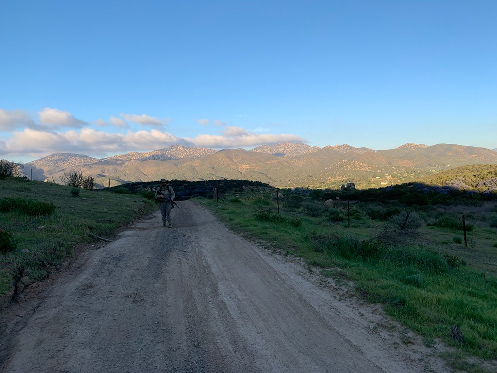
Definitely a tougher hike than I expected. Trail got pretty rough at times, and there are some significant elevation changes, but on the other hand, this time of year the scenery is really beautiful. I think this would be a good one for a future repeat, perhaps starting a bit earlier in the day (although we did start perhaps an hour later than intended). We averaged an approximately 1.5 mph pace.
Hopefully we'll have a larger group for the next one. No issues at all with carrying, and we encountered people shooting along the way. The topography is also really easy to identify, so we had no problems figuring our approximate location on the topographical map we had with us. 


|
|
|
 Win a FREE Membership!
Sign up for the ARFCOM weekly newsletter and be entered to win a free ARFCOM membership. One new winner* is announced every week!
You will receive an email every Friday morning featuring the latest chatter from the hottest topics, breaking news surrounding legislation, as well as exclusive deals only available to ARFCOM email subscribers.

AR15.COM is the world's largest firearm community and is a gathering place for firearm enthusiasts of all types.
From hunters and military members, to competition shooters and general firearm enthusiasts, we welcome anyone who values and respects the way of the firearm.

Subscribe to our monthly Newsletter to receive firearm news, product discounts from your favorite Industry Partners, and more.
Copyright © 1996-2024 AR15.COM LLC. All Rights Reserved.
Any use of this content without express written consent is prohibited.
AR15.Com reserves the right to overwrite or replace any affiliate, commercial, or monetizable links, posted by users, with our own.