|
Attached File Pics from Rolla, MO sent to be by a friend who is up there for the 100 Acre Wood rally. Attached File Attached File |
Daughter lives just south of E Alton IL and is an engineer at Winchester, sounds like there was one touched down near the plant, but missed, she just woke up after a long night, so details are slim. She also went to OK State and said Stillwater got lit up by fires last night 
|
|
Quoted: Need to make a weekend of it and go up to Dayton. Quoted: Quoted: Everyone fair well? Got sporty and loud but that's about it. We were going to take the kids to the Space Center in Huntsville today, but I think I'll be the bearer of bad news and say nope. Need to make a weekend of it and go up to Dayton. |

|
Quoted: The tornado from Belzoni Mississippi that was posted above, that cell tracked across NE MS and into TN and hit here a little after 4 this morning. Windy and loud but no obvious damage yet. PDS warned tornado. The circled markers are tornado damage reports from 12 hours ago. Looks like they are going to get hit again. Attached File |
|
SPC outlook https://www.spc.noaa.gov/products/md/md0199.html 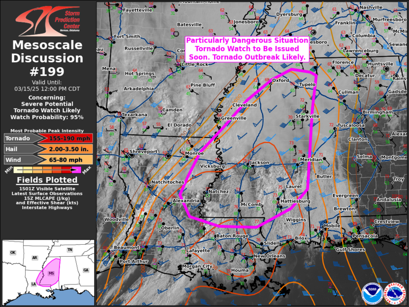 Mesoscale Discussion 0199 NWS Storm Prediction Center Norman OK 1007 AM CDT Sat Mar 15 2025 Areas affected...Eastern Louisiana and much of Mississippi Concerning...Severe potential...Tornado Watch likely Valid 151507Z - 151700Z Probability of Watch Issuance...95 percent SUMMARY...A Particularly Dangerous Situation Tornado Watch will be issued soon. A tornado outbreak with multiple intense to violent long-track tornadoes is likely. DISCUSSION...Morning observational data continues to support a likely tornado outbreak today across parts of eastern Louisiana and Mississippi. 12Z RAOBS from LCH and LIX indicate rich low-level moisture featuring a mean mixing ratio of 14 to 15 beneath a steep EML with mid-level lapse rates of 8 to nearly 9 C/km. This thermodynamic profile, combined with broken cloud cover across Louisiana and southern Mississippi suggest substantial heating will occur and strong instability will be present for much of the day today. The EML will play a critical role in the storm mode today. Discrete supercells are anticipated given the EML which will suppress more widespread convection and also provide enough mid-level dry air for potentially multiple well-organized supercells in close proximity through the day. In addition, 12Z RAOB data along the Gulf Coast is consistent with the data observed the morning of historical tornado outbreaks across Mississippi and Alabama. Strong shear is already present across Louisiana and Mississippi this morning with effective shear 40 to 60 knots at the LIX/LCH/JAN 12Z RAOBs. However, shear will increase further through the morning as mid-level flow strengthens with the mid-level jet streak overspreading more of the warm sector and with secondary surface cyclogenesis in the mid-Mississippi Valley. Early evidence of this secondary low-pressure center has already been observed with a sub-995mb surface low analyzed northwest of Little Rock, Arkansas at 15Z. This surface low will continue to deepen and consolidate through the day which will keep flow backed across the warm sector and result in further strengthening of the already strong low-level jet. By mid-afternoon, a low-level jet of 65 to 70 knots is forecast with corresponding 0-1km SRH of 300 to 500 m2/s2. The presence of nearly pure streamwise vorticity in the lowest 1km will create an environment extremely conducive to the stretching of the ambient low-level vorticity. Confluence bands across Louisiana this morning likely represent the initial supercell initiation zone for the storms of greatest concern this afternoon. Multiple bands of supercells are possible. Once mature supercells develop in the environment south of the messier convection, there should be very little to interrupt their longevity through the afternoon. Given the aforementioned factors, many discrete supercells are expected in an environment which is extremely conducive to tornadic activity. Therefore, a tornado outbreak appears imminent with the potential for multiple, intense to violent long track tornadoes from mid-day through this evening across eastern Louisiana and much of Mississippi. A Particularly Dangerous Situation Tornado Watch will be issued soon to address this threat. ..Bentley/Gleason.. 03/15/2025 ...Please see www.spc.noaa.gov for graphic product... |
 The Historic Tornado Outbreak Of March 15th, 2025, As It Occurred Live...  Likely a SERIOUS TORNADO OUTBREAK Coming - Live Operations and Storm Chasing |
Reed Timmer's back up and broadcasting in Mississippi. MASSIVE TORNADO OUTBREAK - ON THE GROUND |
|
Quoted: Reed Timmer's back up and broadcasting in Mississippi.  https://www.youtube.com/watch?v=tRX1BIg84TE https://www.youtube.com/watch?v=tRX1BIg84TEI was wondering why they were in Forest, MS. Now I see they are trying to intercept one heading directly at Forest, MS. Grew up not far from there in Decatur, MS. Parents still live there. It's about to get sporty for them. I can't imagine trying to track a tornado in that area. It's nothing but tall pine trees. |

|
Quoted: The tornado from Belzoni Mississippi that was posted above, that cell tracked across NE MS and into TN and hit here a little after 4 this morning. Windy and loud but no obvious damage yet. Did you lose power? Lately, we lose power whenever the wind blows. We're stringing extension cords from the generator. It's gonna be late when it hits hard, and that's easier in the daylight. I've got a transfer switch and 220 generator outlet for the Batcave, but it's lying on the bar, waiting to be installed. D'oh!  |
|
Quoted: Nothing too bad in South Huntsville but there was a knarly line I was tracking early this morning that was going northeast pointed toward Arab->Guntersville that looked like it had some rotation or at least some bad straight line winds. Haven't seen anything yet if there was an actual touchdown or not though. Futurecast shows ya'll catching it about 5:00PM, we're not really gonna be in the shit until sometime after 9 or 10:00. |
|
Quoted: Nothing is going to stop this from happening today. All the conditions are primed and ready. Long track, large tornadoes will happen all day. There is no going back. I thought it may die out or just miss us altogether. I looked at it this morning and disregarded it as another blown forecast. Maybe I should take a peak at radar lol. |
|
Quoted: https://www.ar15.com/media/mediaFiles/265591/IMG_9117_jpeg-3490998.JPGPics from Rolla, MO sent to be by a friend who is up there for the 100 Acre Wood rally. https://www.ar15.com/media/mediaFiles/265591/IMG_9115_jpeg-3490995.JPG https://www.ar15.com/media/mediaFiles/265591/IMG_9116_jpeg-3490997.JPG I heard about 10 are dead around Poplar Bluff. We've got relatives in that area, but I think they're okay, except for some trees and a barn that blew away. |
|
Quoted: I thought it may die out or just miss us altogether. I looked at it this morning and disregarded it as another blown forecast. Maybe I should take a peak at radar lol. I honestly wish it did. Unfortunately is going to be a record setting day in terms of tornadoes. I believe these will run all night through the Ohio Valley. There is literally nothing in the way of these things, the atmosphere is ripe as fuck. |
|
Quoted: Tylertown MS heads up. Large tornado with debris incoming. Quoted: Sartinville area tornado is lofting debris 30k feet up  Same tornado for both of these
|
|
Quoted: I honestly wish it did. Unfortunately is going to be a record setting day in terms of tornadoes. I believe these will run all night through the Ohio Valley. There is literally nothing in the way of these things, the atmosphere is ripe as fuck. Quoted: Quoted: I thought it may die out or just miss us altogether. I looked at it this morning and disregarded it as another blown forecast. Maybe I should take a peak at radar lol. I honestly wish it did. Unfortunately is going to be a record setting day in terms of tornadoes. I believe these will run all night through the Ohio Valley. There is literally nothing in the way of these things, the atmosphere is ripe as fuck. I keep looking at live radar. It may totally miss North Carolina unless something pushes it east. I haven’t seen any recent forecasts. |
|
Quoted: Futurecast shows ya'll catching it about 5:00PM, we're not really gonna be in the shit until sometime after 9 or 10:00. Quoted: Quoted: Nothing too bad in South Huntsville but there was a knarly line I was tracking early this morning that was going northeast pointed toward Arab->Guntersville that looked like it had some rotation or at least some bad straight line winds. Haven't seen anything yet if there was an actual touchdown or not though. Futurecast shows ya'll catching it about 5:00PM, we're not really gonna be in the shit until sometime after 9 or 10:00. |

|
Quoted: Taylorsville just took a direct hit https://www.ar15.com/media/mediaFiles/381696/Screenshot_2025-03-15_151119_png-3491182.JPG |
|
Quoted: Taylorsville just took a direct hit https://www.ar15.com/media/mediaFiles/381696/Screenshot_2025-03-15_151119_png-3491182.JPG Yeah, tons of debris. And getting some footage of the live tornado right now.... MASSIVE TORNADO OUTBREAK - ON THE GROUND |
|
Quoted: Looks like it. Quoted: Quoted: Taylorsville about to get hit again or very close to it. Attached File |
I got my 'naderpants on and i'm operating at NADERCON 3 right now. Nothing major coming to me but some of the scattered storms seem to be forming up and I see one small little bugger that's almost straight lining to my specific AO but it's a ways out so could disperse or get worse.
|
|
power is out here in central KY. I was watching Good Simple Living when I dozed off and my wife said the power flickered. Let it go for about 20 minutes, fired up the firman genny, and started running cords to the chest freeze, fridge, one of the microwaves, and starlink. So far so good. Not what I wanted to do today while fighting a cold. I'm going to expedite getting the plug put next to my panel now so that I can run the house as normal. It's approaching time to get a power bank to keep Starlink isolated as well. |