|
[#1]
Quoted: As I posted earlier, I have read the FEMA response plan for this event. It's not classified, but I can't share it to the public, except for mil, leo, first responders, etc and I will say there is a pretty detailed plan to respond to it, some of which I have posted earlier in fema links that give a vrry broad overview. The only thing I think they have wrong is the amount of deaths, with projections I have seen from 25 to 300K, I think those numbers are low, assuming an 8+ quake with subsequent tsunami. I would project that 85% of those who are west of I5 when it occurs will perish and 25-35% of those east of I5 but west of the Cascades. The Army organization I am assigned to is responsible for disaster relief logistics on a national scale for North America and this is one of many scenarios that we have studied. It keeps us up at night. Neighboring Massachusetts has a much more detailed plan, but the problem is they leave the real underlying source of loss of life/property out of their plan. The only subsurface modeling they have done for liquefaction is in a narrow strip down the center of the state. The population is along the coast- Boston- and most of the city is built on fill and it is a liquefaction certainty in any significant earthquake scenario. For instance, "Fenway" is derived from "Fens", which is an old word for a swamp. The "Back Bay" of Boston is literal- it was a bay that was filled in. New England has an earthquake history like the rest of the planet, but we appear woefully (perhaps willfully) ignorant. |
|
|
|
[#2]
Quoted:
It could be four hundred years away or today. Quoted:
DesuDurDesu: https://i.imgur.com/VoW6CLa.png |
|
|
|
[#3]
Quoted: As I posted earlier, I have read the FEMA response plan for this event. It's not classified, but I can't share it to the public, except for mil, leo, first responders, etc and I will say there is a pretty detailed plan to respond to it, some of which I have posted earlier in fema links that give a vrry broad overview. The only thing I think they have wrong is the amount of deaths, with projections I have seen from 25 to 300K, I think those numbers are low, assuming an 8+ quake with subsequent tsunami. I would project that 85% of those who are west of I5 when it occurs will perish and 25-35% of those east of I5 but west of the Cascades. The Army organization I am assigned to is responsible for disaster relief logistics on a national scale for North America and this is one of many scenarios that we have studied. It keeps us up at night. |
|
|
|
[#4]
Quoted:
I live here....and my skin isn't so thin that I can't take some teasing about the political climate and the wishes these far left jokers were gone all of a sudden Quoted:
Quoted:
You should really read the thread before you get all butthurt. Paul originally was making reference to all the fuckers wishing that Portland and Seattle would slide of into the ocean...killing all the Americans living there. He even intimated they were retards for wishing so. |
|
|
|
[#5]
Quoted: Can you expand on why you think they'd be so high in those areas in Oregon? Ground liquifaction part of that reason? Survival after the quake with lack of resources part of those numbers? Then take the time to look at these Slides look at the Federal response, specifically the ISB's (Incident Response Bases) which are initial logistic response areas setup by FEMA, DHS, MIL as logistic response areas to respond to a disaster. These take a week to 10 days to establish. Yes some initial life saving and rescue can take place before then, but it would be limited in scope. Continuing on in those slides, the Federal Government then establishes FSA's (Forward Support Area's or Federal Support Areas IIRC). Those take additional time, so by the time that you have integrated government response going door to door you're looking at 2 weeks minimum. Yes, that will have occurred earlier in more functional locales and local first responders, but it may take as long as months before every door is knocked on in the I5 corridor between Seattle WA and Medford Ore, depending on the scale of the subduction Tsunami, some of the larger scale predictions for the Cascadia Subduction magnitude 9 have it go all the way from Eureka CA to Vancouver Island BC with a tsunami wave coming inland 25 -50 miles. |
|
|
|
[#6]
Quoted: If you look at this Link specifically on the slides addressing Operational Coordination, Critical Transportation and Infrastructure Systems. Those slides indicate the anticipated destruction of basic infrastructure, (Electrical grid, roads & bridges, and government building capable of operating as an emergency operations center, if it's shown in red on the slide, it's dead). Then take the time to look at these Slides look at the Federal response, specifically the ISB's (Incident Response Bases) which are initial logistic response areas setup by FEMA, DHS, MIL as logistic response areas to respond to a disaster. These take a week to 10 days to establish. Yes some initial life saving and rescue can take place before then, but it would be limited in scope. Continuing on in those slides, the Federal Government then establishes FSA's (Forward Support Area's or Federal Support Areas IIRC). Those take additional time, so by the time that you have integrated government response going door to door you're looking at 2 weeks minimum. Yes, that will have occurred earlier in more functional locales and local first responders, but it may take as long as months before every door is knocked on in the I5 corridor between Seattle WA and Medford Ore, depending on the scale of the subduction Tsunami, some of the larger scale predictions for the Cascadia Subduction magnitude 9 have it go all the way from Eureka CA to Vancouver Island BC with a tsunami wave coming inland 25 -50 miles. 
|
|
|
|
[#7]
Quoted:
As long as it just takes everyrhing west of I-5, I'm OK with that. |
|
|
|
[#8]
Quoted: Thank you again Sir |
|
|
|
[#9]
This thread is bumming me out, I need a drink. On the positive side, I have EQ insurance
|
|
|
|
[#10]
Quoted:
To further clarify, we are 6 months post Hurricane Maria and 20% of PR still doesn't have electricity, and that is a microcosm of what the Cascadia Subduction 9 earthquake / Tsunami would be. It would take more than a decade to re-establish full infrastructure to the western PNW. Quoted:
Quoted: Thank you again Sir |
|
|
|
[#11]
Quoted:
What will happen when the Yellowstone Supervolcano blows? I can't see much in the way of aircraft SAR support for much of western MT due to ash. It's possible ground traffic would be limited as well. |
|
|
|
[#12]
Quoted:
As I posted earlier, I have read the FEMA response plan for this event. It's not classified, but I can't share it to the public, except for mil, leo, first responders, etc and I will say there is a pretty detailed plan to respond to it, some of which I have posted earlier in fema links that give a vrry broad overview. The only thing I think they have wrong is the amount of deaths, with projections I have seen from 25 to 300K, I think those numbers are low, assuming an 8+ quake with subsequent tsunami. I would project that 85% of those who are west of I5 when it occurs will perish and 25-35% of those east of I5 but west of the Cascades. The Army organization I am assigned to is responsible for disaster relief logistics on a national scale for North America and this is one of many scenarios that we have studied. It keeps us up at night. Quoted:
Quoted:
It's the plot for "Deep Winter" by Thomas Sherry, but for real. The book was written in 2007 so this has been on people's minds for a while. It wasn't a happy book. The only thing I think they have wrong is the amount of deaths, with projections I have seen from 25 to 300K, I think those numbers are low, assuming an 8+ quake with subsequent tsunami. I would project that 85% of those who are west of I5 when it occurs will perish and 25-35% of those east of I5 but west of the Cascades. The Army organization I am assigned to is responsible for disaster relief logistics on a national scale for North America and this is one of many scenarios that we have studied. It keeps us up at night. That doesn't take into account what would be happening in the Pacific, our ability to project power would be impacted because I would assume the military would be fully engaged in relief efforts. Would the Chinese go after Taiwan? Would the Norks go after the ROK? Would the nations of the Islamic world go after Israel? This would affect the entire world. |
|
|
|
[#13]
Quoted:
Will it break off Portland to Seattle? If so, let's get this party started. |
|
|
|
[#14]
@elcope
How would Eugene, OR fare destruction wise? 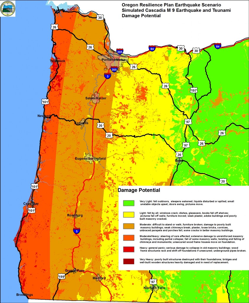
Looks like light yellow? Is this due to elevation? |
|
|
|
[#15]
Salt lake is due for a big one. Memphis and St Louis are due for big ones. Charleston, SC is due for a big one.
Hug your loved ones as often as you can |
|
|
|
[#16]
Quoted:
Is there where commiefornia finally falls off? 
|
|
|
|
[#17]
Quoted:
Maybe the whole west side of OR and WA will slide into the ocean and get rid of all the libs from kali. 
|
|
|
|
[#18]
Looks like I'll be electing for the cash option when I win this year's HGTV dream home in Gig Harbor

|
|
|
|
[#19]
Quoted: Awesome, I’m literally a half mile east of the I5 
I'm about 5-6 miles east of I5 |
|
|
|
[#20]
Quoted:
this is how we spot the transplants...
I'm about 5-6 miles east of I5 You're about 5-6 miles east of 'the 5'. |
|
|
|
[#21]
Quoted:
@elcope How would Eugene, OR fare destruction wise? https://thebridge.agu.org/files/2014/05/OR-CSZ-damage-potential-map-842x1024.jpg Looks like light yellow? Is this due to elevation? |
|
|
|
[#22]
Quoted:
I'm not sure that's how log scales work. All I'm saying is that people keep showing that tsunamis can happen in Puget Sound IF THE EARTHQUAKE OCCURS IN PUGET SOUND. I also reviewed several charts of Pacific Ocean tsunamis in originating in various locations and none of them "turned the corner" down into Puget Sound. Could a large earthquake in the Cascadia trigger an earthquake or slide in Puget Sound, sure it could happen. Guess I'd need to hear from an expert how likely that is. Hell, it COULD be some major linked event that causes volcanoes and all sorts of stuff. California MIGHT move 200' into the ocean. I think most likely there would be a large quake in one location with the devastation directly caused by ONE event. |
|
|
|
[#23]
Quoted: That looks odd to me. The Willamette Valley from Eugene to Portland has very little elevation change. I don't know much geology. Is that distinct eugene/springfield unique geology-wise compared to the surrounding areas? |
|
|
|
[#24]
Quoted:
When I lived on the west coast, it was just referred to as 'the 5'. No 'I' required. You're about 5-6 miles east of 'the 5'. |
|
|
|
[#25]
Quoted:
@elcope How would Eugene, OR fare destruction wise? https://thebridge.agu.org/files/2014/05/OR-CSZ-damage-potential-map-842x1024.jpg Looks like light yellow? Is this due to elevation? |
|
|
|
[#26]
Quoted:
When I lived on the west coast, it was just referred to as 'the 5'. No 'I' required. You're about 5-6 miles east of 'the 5'. Quoted:
Quoted:
this is how we spot the transplants...
I'm about 5-6 miles east of I5 You're about 5-6 miles east of 'the 5'. "You want to head up 5, or take the coast highway? |
|
|
|
[#27]
Quoted:
Honestly not sure. Was hoping someone could give me some insight on it. Quoted:
Quoted: That looks odd to me. The Willamette Valley from Eugene to Portland has very little elevation change. I don't know much geology. Is that distinct eugene/springfield unique geology-wise compared to the surrounding areas? 
|
|
|
|
[#28]
Found this. Looks like Eugene could be sitting on millions of years old rock with just a thin layer of sediment. I used to climb at the basalt columns in downtown Eugene.
http://www.vanessasalvia.com/exposing-lane-countys-geology/ ETA looking closer at the map in that link most of Eugene is sitting on extremely old rock. |
|
|
|
[#29]
Quoted: It’s pretty flat from Eugene to Portland low elevation. http://www.orwild.org/sites/default/files/pdf-files/Oregon_topo_map.jpg The topo it does look pretty flat. |
|
|
|
[#30]
Quoted:
Found this. Looks like Eugene could be sitting on millions of years old rock with just a thin layer of sediment. I used to climb at the basalt columns in downtown Eugene. http://www.vanessasalvia.com/exposing-lane-countys-geology/ |
|
|
|
[#31]
Quoted:
The chart I looked at was showing a drop of 1/2 of the Richter scale or more. And there was a chart specifically for the type of rock around the Cascadia. All I'm saying is that people keep showing that tsunamis can happen in Puget Sound IF THE EARTHQUAKE OCCURS IN PUGET SOUND. I also reviewed several charts of Pacific Ocean tsunamis in originating in various locations and none of them "turned the corner" down into Puget Sound. Could a large earthquake in the Cascadia trigger an earthquake or slide in Puget Sound, sure it could happen. Guess I'd need to hear from an expert how likely that is. Hell, it COULD be some major linked event that causes volcanoes and all sorts of stuff. California MIGHT move 200' into the ocean. I think most likely there would be a large quake in one location with the devastation directly caused by ONE event. Quoted:
Quoted:
I'm not sure that's how log scales work. All I'm saying is that people keep showing that tsunamis can happen in Puget Sound IF THE EARTHQUAKE OCCURS IN PUGET SOUND. I also reviewed several charts of Pacific Ocean tsunamis in originating in various locations and none of them "turned the corner" down into Puget Sound. Could a large earthquake in the Cascadia trigger an earthquake or slide in Puget Sound, sure it could happen. Guess I'd need to hear from an expert how likely that is. Hell, it COULD be some major linked event that causes volcanoes and all sorts of stuff. California MIGHT move 200' into the ocean. I think most likely there would be a large quake in one location with the devastation directly caused by ONE event. https://www.newyorker.com/magazine/2015/07/20/the-really-big-one People don't think Tsunami be like it is, but it Do.  Perhaps it would help, if you visualize it like an an incoming tide that doesn't stop. |
|
|
|
[#32]
Quoted: It's pretty flat from Eugene to Portland low elevation. http://www.orwild.org/sites/default/files/pdf-files/Oregon_topo_map.jpg |
|
|
|
[#33]
Quoted:
So only that thin layer of sediment would be prone to shifting and the rock would likely remain in place? Quoted:
Quoted:
Found this. Looks like Eugene could be sitting on millions of years old rock with just a thin layer of sediment. I used to climb at the basalt columns in downtown Eugene. http://www.vanessasalvia.com/exposing-lane-countys-geology/ |
|
|
|
[#34]
Quoted:
This thread is bumming me out, I need a drink. On the positive side, I have EQ insurance |
|
|
|
[#35]
Quoted:
If I had to guess, yes. Probably elevation. Quoted:
Quoted:
@elcope How would Eugene, OR fare destruction wise? https://thebridge.agu.org/files/2014/05/OR-CSZ-damage-potential-map-842x1024.jpg Looks like light yellow? Is this due to elevation? Lack of washing, smooshed hippies acting like glue holds the Eugene/Springfield area together.
|
|
|
|
[#36]
Quoted: It's hippies. Lack of washing, smooshed hippies acting like glue holds the Eugene/Springfield area together. Wtfboombrb thanks for looking. Looks like it'll at least be survivable in Eugene area. |
|
|
|
[#37]
Quoted:
When I lived on the west coast, it was just referred to as 'the 5'. No 'I' required. You're about 5-6 miles east of 'the 5'. |
|
|
|
[#38]
Quoted:
 Death to Americans! Death to Americans! (retarded sons-of-bitches) |
|
|
|
[#39]
Quoted:
What will happen when the Yellowstone Supervolcano blows? I can't see much in the way of aircraft SAR support for much of western MT due to ash. It's possible ground traffic would be limited as well. Quoted:
Quoted:
Quoted: Thank you again Sir If the prevailing upper level winds are strong from the NW, you might be OK, if you start driving NW as fast as possible. Leave everything behind and plan on never returning. Throw extra engine air filters, and some dust particulate masks into the trunk of your car. |
|
|
|
[#40]
|
|
|
|
[#41]
Quoted:
Well.....I've been here for 55 years....and the only ones I ever hear say the 5....Are usually Californicators. Quoted:
Quoted:
When I lived on the west coast, it was just referred to as 'the 5'. No 'I' required. You're about 5-6 miles east of 'the 5'. |
|
|
|
[#42]
Quoted:
I'm reasonably sure that if an 8+ event happened most insurance companies would declare bankruptcy. Quoted:
Quoted:
This thread is bumming me out, I need a drink. On the positive side, I have EQ insurance |
|
|
|
[#43]
Quoted: What will happen when the Yellowstone Supervolcano blows? I can't see much in the way of aircraft SAR support for much of western MT due to ash. It's possible ground traffic would be limited as well. Not really, but likely kill 85-95% of all life on earth. |
|
|
|
[#44]
Long overdue since '89 and that was nothing compared to '06.
|
|
|
|
[#45]
West coast guys send your ammo forts to NC for safe keeping
|
|
|
|
[#46]
Quoted:
The least of your worries will be the actual kill zone from the volcano. The real issue will be the amount of sunlight that the ash blocks out and causes very low yield harvests in addition to some of the most fertile land in the world being buried. It will result in a good chunk of the human population dying, more or less. 
|
|
|
|
[#47]
Quoted:
This thread is bumming me out, I need a drink. On the positive side, I have EQ insurance |
|
|
|
[#48]
Quoted: Well.....I've been here for 55 years....and the only ones I ever hear say the 5....Are usually Californicators. Good to hear they're going home after fucking things up here. |
|
|
|
[#49]
Quoted: If you look at this Link specifically on the slides addressing Operational Coordination, Critical Transportation and Infrastructure Systems. Those slides indicate the anticipated destruction of basic infrastructure, (Electrical grid, roads & bridges, and government building capable of operating as an emergency operations center, if it's shown in red on the slide, it's dead). Then take the time to look at these Slides look at the Federal response, specifically the ISB's (Incident Response Bases) which are initial logistic response areas setup by FEMA, DHS, MIL as logistic response areas to respond to a disaster. These take a week to 10 days to establish. Yes some initial life saving and rescue can take place before then, but it would be limited in scope. Continuing on in those slides, the Federal Government then establishes FSA's (Forward Support Area's or Federal Support Areas IIRC). Those take additional time, so by the time that you have integrated government response going door to door you're looking at 2 weeks minimum. Yes, that will have occurred earlier in more functional locales and local first responders, but it may take as long as months before every door is knocked on in the I5 corridor between Seattle WA and Medford Ore, depending on the scale of the subduction Tsunami, some of the larger scale predictions for the Cascadia Subduction magnitude 9 have it go all the way from Eureka CA to Vancouver Island BC with a tsunami wave coming inland 25 -50 miles. I have been looking at Tahsis BC, I've been there a few times and loved it. Maybe not so much now. |
|
|
|
[#50]
I live on zero bank waterfront on the puget sound on dyes inlet and my neighbor grew up and has been/lived in his house and on property for 60 years and remembers seeing the bay rise a few feet post one of the earthquakes, A buddy thats in the excavation business when he was developing property had a civil engineer that had enough liberal college tuition spent that he had clout when there was a issue with wetlands in deveolopment of property that was pretty successful when he came up against the epa,dnr etc...stating things like the orphan quake was the reason for certain wetlands and therefore not held to certain regs that others would be for developing.
|
|
|
 Win a FREE Membership!
Sign up for the ARFCOM weekly newsletter and be entered to win a free ARFCOM membership. One new winner* is announced every week!
You will receive an email every Friday morning featuring the latest chatter from the hottest topics, breaking news surrounding legislation, as well as exclusive deals only available to ARFCOM email subscribers.

AR15.COM is the world's largest firearm community and is a gathering place for firearm enthusiasts of all types.
From hunters and military members, to competition shooters and general firearm enthusiasts, we welcome anyone who values and respects the way of the firearm.

Subscribe to our monthly Newsletter to receive firearm news, product discounts from your favorite Industry Partners, and more.
Copyright © 1996-2024 AR15.COM LLC. All Rights Reserved.
Any use of this content without express written consent is prohibited.
AR15.Com reserves the right to overwrite or replace any affiliate, commercial, or monetizable links, posted by users, with our own.