|
Posted: 7/29/2006 11:00:20 PM EDT
I love looking at mil stuff on google earth. Post your favorites.
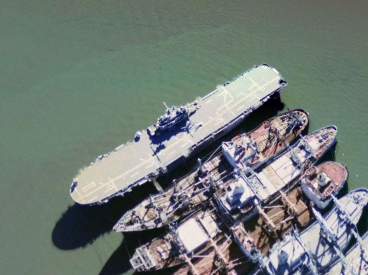
Imageshack resized all my photos for some reason Helos at NO airport, I bet this was taken during katrina  typhoon  3 decomissioned carriers  Is this the Missouri or the Iowa? Cant remember which is in san fran  Barksdale  Barksdale again  Jets in Moscow  I lived here for 5 months  
|
|
|
|
[#1]
Dude, lat and long on the Typhoon please.
I would damn near give my left nut to go on one of those (and from what I hear with Russian reactors it might come to that ).BTW: At work this morning I met this old man wearing a submarine hat. Turns out he was in the sub force in 1938 and on through WWII. He was on the boat that sunk the Yamato. How cool is that? |
|
|
|
[#2]
I have a question about Google earth.
I have a Pentium 4 3.0Ghz. 2GB Ram, 160Gb Hard drive, and all the monitor space anyone could ever want. If I download google earth is it going to run on my system without bogging it down a lot? It looks really cool, and I want to get it. |
|
|
|
[#3]
Mighty Mo is in Pearl Harbor.
Where was the shot of the place you live for 5 months? It looks just like the place I lived if a few improvements were made. |
|
|
|
[#4]
Al asad. So if the Mo is in pearl, is that the Iowa? I know the Wisconsin is in Norfolk, and I think the NJ is in NJ. Typhoon is at: 64°34'56.19"N 39°48'55.32"E |
|
|
|
|
[#5]
From their website: The Google Earth client requires certain system configurations in order to run smoothly. Minimum configuration: * Operating System: Windows 2000, Windows XP * CPU: Pentium 3, 500Mhz - System Memory (RAM): 128MB RAM * Hard Disk: 400MB free space * Network Speed: 128 Kbits/sec * Graphics Card: 3D-capable with 16MB of VRAM * Screen: 1024x768, "16-bit High Color" screen Recommended configuration: * Operating System: Windows XP * CPU: Pentium 4 2.4GHz+ or AMD 2400xp+ * System Memory (RAM): 512MB RAM * Hard Disk: 2GB free space * Network Speed: 768 Kbits/sec * Graphics Card: 3D-capable with 32MB of VRAM * Screen: 1280x1024, "32-bit True Color" screen Yes, it should be able to run it unless you use a lot of the memory for other things. The biggest thing is the network speed needs to be fast. |
|
|
|
|
[#6]
Um, yeah, I think that might just about be enough... |
|
|
|
|
[#7]
Ripper? |
||
|
|
|
[#8]
you won't notice the impact on your system. I run it on a considerably older one with ease.
|
|
|
|
[#9]
Yep yep, cans right by the chow hall. |
|||
|
|
|
[#10]
thats the mothball fleet outside of benicia CA(south of vallejo, north bay area) its a shame, its gotten smaller over the years...
im not sure whats out there though. |
|
|
|
[#11]
This is where I landed when we parachuted into the invasion of Panama (Omar Torrijos Int'l. Airport).

|
|
|
|
[#12]
The high one day was 130 degrees, we fried on egg on MSR Tampa

|
|
|
|
[#13]
I tried saving an image, and when I went to open the saved jpeg I got a blacked out pic. what gives? How do I save the pics?
|
|
|
|
[#14]
Go left 9 and up 1 for mine. I was fortunate enough to spend a little bit more time in mine though. Sometimes us "old" guys got it like that. Semper Fi |
||||
|
|
|
[#15]
The easiest way is make it a power point slide then save as a JPEG, upload to photobucket (or something like it) |
|
|
|
|
[#16]
|
|
|
|
[#17]
That's a lot of JDAM's 
|
|
|
|
|
[#18]
Iowa is in San Fran
|
|
|
|
[#19]
Check out Shaw AFB. There's SHITLOAD of F-16s on the tarmac. I didn't count, but it's easily 30+.
|
|
|
|
[#20]
I was looking at Whiteman AFB, and I don't see any Stealth bombers. I take it they keep those in the garage? What other bases have stealth aircraft?
|
|
|
|
[#21]
The Russian planes pic should be the Monino aviation museum, just outside of Moscow. Whichy is the largest aviation Museum in Russia.
|
|
|
|
[#22]
Edwards AFB

|
|
|
|
[#23]
I'd like to sit and drink a few cold ones with you and hear all about that.  Seriously. Seriously.All those aircraft coming south diverted my flight out of Costa Rica that morning back in '89. |
|
|
|
|
[#24]
Isn't that why they call them "stealth" |
|
|
|
|
[#25]
HHhhhmmmmmmmmmmmmm I suppose so. 
|
||
|
|
|
[#26]
I couldn't resist, it was too easy. |
|||
|
|
|
[#27]
that is f'ing cool right there. |
|
|
|
|
[#28]
Wow, no kidding. When I moved up to that area 25 years ago, there were rows and rows of old ships. Now there's little more than a handful. USS IOWA (BB-61) Moves To Benicia, California |
|
|
|
|
[#29]
heres where i went to basic training. i marked my bay in the building i lived in.

|
|
|
|
[#30]
Your screenshot-fu is very fucking weak.
After you paste the image into Paint, try resizing it so you don't waste space with the white area, task bar, etc. Also, ALT+PrintScr will copy only the active window to the clipboard, by the way. |
|
|
|
[#31]
Actually all he has to do it in Google Earth, just go to File > Save Image and it will save the image only not the entire app itself. |
|
|
|
|
[#32]
C-5 refueling in N Kalifornia
 B-52's at Diego Garcia  AC-130's at Hurlburt Field in Florida  Bomb Iraqi planes in western Iraq 
|
|
|
|
[#33]
Hmm. They updated Google Earth's Anaconda pics. My tank is gone from where it used to be. Near as I can tell, they only updated it about four-six months though, still a photo taken before the end of 2004.
NTM |
|
|
|
[#34]
How do you find islands in the oceans? I typed in Johnson Atoll and it couldn't find a record. Same thing with Corrigedor and Iwo Jima?
|
|
|
|
[#35]
this is where 2 sr71s USED to be. my cousin found them, and sent me the coordinates. i posted it on here and someone said "great, now you're gonna make the gov't work even harder to make sure they filter stuff"
there were two of them with the noses pointing south, right below where the pin is. the picture is DEFINITELY not updated, which means that someone did notice and had them 'removed' they wouldnt have been sitting there if they were out of commission....... 
|
|
|
|
[#36]
That is fucking cool, Ranger. 
|
|
|
|
|
[#37]
Thanks! Rhode island  Norfolk  New Orleans, assualt ships under construction. One is done now  Gitmo  Karabila 
|
||
|
|
|
[#38]
More cool stuff with google earth
      bulding I took picture from 
|
|
|
|
[#39]
Choppers outside grozny, google earth says checnya isnt a country. I guess it agrees with the russians.
Someone find me some russian tanks!  Russia says no planes for checyans. 
|
|
|
|
[#40]
Grozny is fucked up!
 
|
|
|
|
[#41]
There was a site, not sure if it's still around called "Terraserver" or something like that...it was a less user-friendly version of Google Earth from way back in the day...I saw a ton of B-2s at Whiteman AFB in one of their pictures. |
||
|
|
|
[#42]
|
|
|
|
[#43]
PLEASE
SOME one find the the famous mothball fleet of old navy ships. |
|
|
|
[#45]
|
|
|
|
[#46]
I run Google Earth on my 1ghz PIII, 256 mb RDRAM, 80 gig HDD. Runs just fine. Jim |
||
|
|
|
[#47]
I downloaded it right after I posted that, and I have been addicted to it ever since, and it runs great. I think I need to go to a 30 inch monitor though this 24 is cool and all but wow I could only imagine. 
|
|||
|
|
|
[#48]
Does anyone know what this is? From Suisun bay:
 A few more: 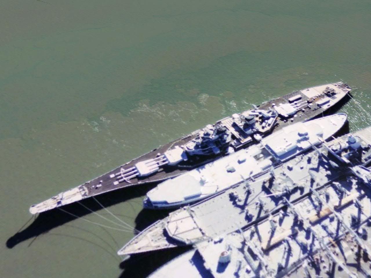 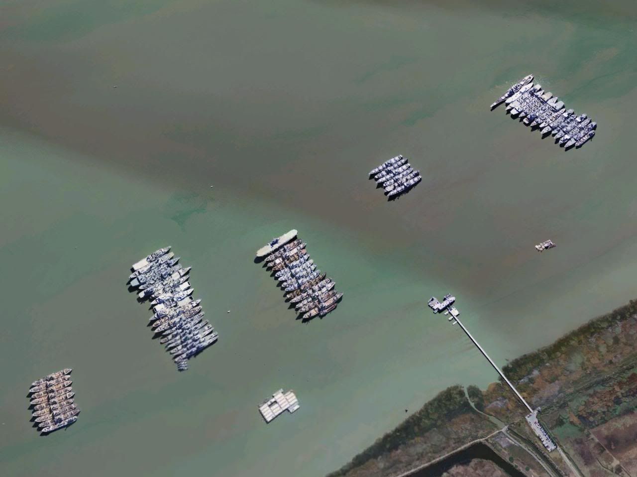
|
|
|
|
[#49]
The picture HAS BEEN updated. And they WERE out of commission and were waiting to be taken a part and REMOVED by truck to a couple of museums. I was stationed at Edwards from 2000 to 2005 and looked at the base with Google Earth numerous times and here recently Google updated the images of the base. While I was stationed there I also worked part time for the security company that provides security at the NASA Dryden Flight Research Center (where the SR's were parked and who last operated them) and got to check out the SR's a few times. There are still two SR's at Edwards. One at the base's museum.  And one near the visitors center at NASA Dryden Flight Research Center.  And there is one SR-71 and one A-12 near by at the Blackbird Airpark in Palmdale, CA.  |
|
|
|
|
[#50]
Does anyone have any ideas as to what this is? It's in the hills above the east bay (morrison canyon).
The thing on the top left is a wire mesh airplane on its tail, and the area on the right appears to be a helicopter landing area. I don't know what the two white things on the bottom are. Someone said it was a radar testing station, but I don't know. 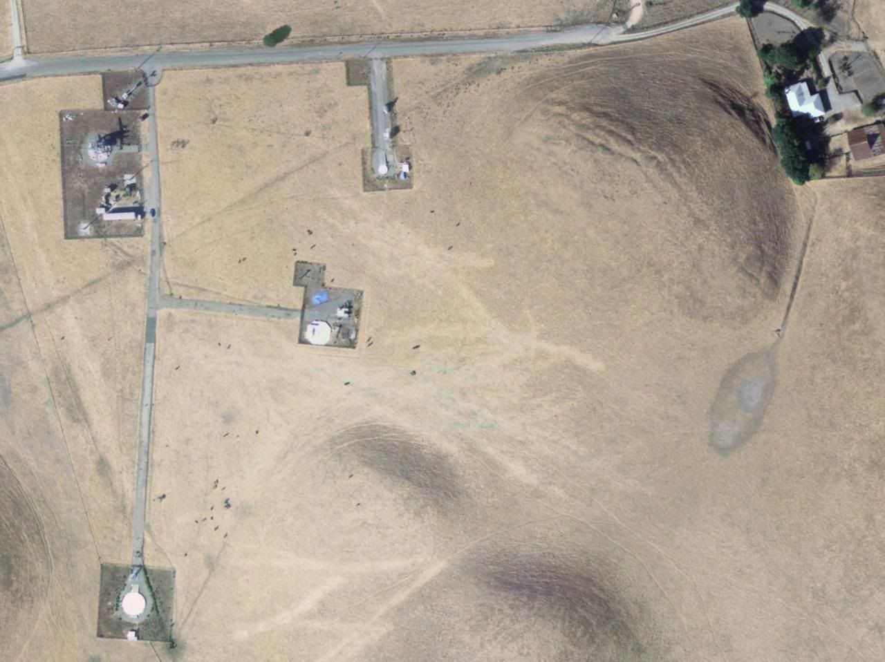
|
|
|
 Win a FREE Membership!
Sign up for the ARFCOM weekly newsletter and be entered to win a free ARFCOM membership. One new winner* is announced every week!
You will receive an email every Friday morning featuring the latest chatter from the hottest topics, breaking news surrounding legislation, as well as exclusive deals only available to ARFCOM email subscribers.

AR15.COM is the world's largest firearm community and is a gathering place for firearm enthusiasts of all types.
From hunters and military members, to competition shooters and general firearm enthusiasts, we welcome anyone who values and respects the way of the firearm.

Subscribe to our monthly Newsletter to receive firearm news, product discounts from your favorite Industry Partners, and more.
Copyright © 1996-2024 AR15.COM LLC. All Rights Reserved.
Any use of this content without express written consent is prohibited.
AR15.Com reserves the right to overwrite or replace any affiliate, commercial, or monetizable links, posted by users, with our own.