|
Posted: 3/5/2006 9:24:48 AM EDT
Friday, March 03, 2006
The Bloody Borders Project Worldwide Islamic Terrorism Since September 11th Back in December, the Baron wrote a post in which he mentioned Samuel Huntington’s well-known quote about Islam’s “bloody borders”. The imagery was graphic and startling. In my ignorance, I asked the Baron if he could draw a simple map delineating these boundaries. I wanted to be able to see these “fault lines”. I wanted to see if a pictorial representation would help me better to understand the reach and the destruction of what the Islamofascists have wrought. The Baron reminded me that no such map could be made. Islamic terrorism takes place among, between, and inside many countries. The constant, vicious, lethal storm of Islamist violence stretches from equatorial Africa and the Barbary coast, across the Holy Land and the Arabian heartland, snaking through the mountains and plains of South Asia, making its way along the littoral of Indochina and the Indian Ocean, and ending in the archipelagos of the Pacific Rim. Remember when we heard about “The New World Order”? Few of us envisioned a world order straight from the gates of hell. On that beautiful September day in 2001, the sky a deep cerulean blue, we watched bodies, people, people like you and me, leaping, jumping arm-in-arm, sailing through space. We never saw them land. Everyone has his own interior landscape of that September day. For many of us, September 12th was indeed the commencement of a New World Order. It was not an order founded on innocence or optimism or platitudes. It had become a world of resolve in the face of uncertainty. Whatever happened, we would not go quietly again. We are well past the hopes and fears of the 20th century. The atomic Armageddon so endlessly prophesied died in silence. The old ideologies belong to the ages. We have come to some new, yet equally terrible, darkling plain. Where there were previously two superpowers and three “worlds”, we have now, instead, a roiling, ever-changing political and religious battle. Who could have predicted, when Francis Fukuyama so dismissively consigned history to its own dustbin, that only a few years later new historical battle lines would be drawn? Who, reading the End of History, could have foreseen the Bush Doctrine? Samuel Huntington proposes that, in the coming war between cultures, we will be confronted with “the West against the rest.” Leaving aside the inherent simplistic reduction here, he does have a point. If, by “the rest”, he means those who have no shared history with the West — that is, who do not spring from its essentially Judaeo-Christian foundations, nor partake of its Greco-Roman understanding of the law — he does have a point. However, many of the previously colonized cultures have adopted and adapted this essentially Western Weltanschauung. One could include, for example, Japan, or India. Differences among cultures are not inherently conflictual. The growing alliance between Japan and the West is born of Japan’s fear of China, and the West’s need for an ally in that part of the world. A developed, Westernized, and cohesive ally. Of particular interest to Gates of Vienna are the cultural clashes which Islam has created as it comes up against whatever it considers “foreign”. Think of it as a kind of cultural spontaneous combustion. This has been a perennial problem for Islam, one which was resolved in its favor several times through brute force, before the gradual decline of the Muslim world. Were it not for petroleum, Islam might have vanished. Now, however, its more powerful tribes float on a sea of luxury while the “Arab street” wallows in its own uncollected garbage. At the moment, in early 2006, Islam’s infiltration of other cultures, its demand for the dhimmification of others, and its absolutist and utopian visions, have created a long fault line of chronic bloody terrorism. * * * * * * * * * * * * * * * The Baron explained the difficulties inherent in making any map encompassing what I wanted to see. To be accurate, his cartography would have to include the ongoing quotidian massacres that have occurred and continue behind the screen erected by the legacy media, the screen on which they display the bread and circuses meant to trivialize and distract. What does it matter that thirty Hindus died in Kashmir today, or that 350 women were raped in Darfur, when there is the serious matter of Paris Hilton videos to be considered? As Providence would have it, late in December the Baron discovered a series of tables at The Religion of Peace (TROP) showing the location and casualties for every Islamic terrorist attack since September 11th. “All you have to do,” I told the Baron, “is put those little numbers on a map.” He didn’t say anything for a long time. Now I understand his silence; in fact, I find it rather admirable. As it turned out, what I wanted took him well over a hundred hours of his spare time to complete… The things we do for love… All Islamic terror attacks since September 11, 2001 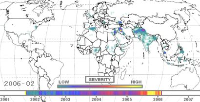 Here’s how he did it: he used the more than 1,300 place names from TROP and matched them to various online maps and gazetteers, particularly Falling Rain. The locations in Iraq, Pakistan, and India were particularly difficult to match, due to wildly varying spellings. The results were collected in a database, and then he wrote hundreds of lines of program code to create the images, learning the rudiments of Macromedia Flash MX to build the animation. Meanwhile, having had the time to repent in leisure, I learned the hard wisdom of being careful about what you ask for. Those endless hours hunched over the keyboard staring at the names of villages in Hindi and Urdu and Arabic and Tagalog has left the Baron’s eyesight a little worse for the wear. Never mind; his labors produced a wonder. You cannot watch the display representing the ongoing murderous intent of so many groups, all of them under the umbrella of a brutally insane worldview, without realizing with a sinking heart what we are up against. Every time a little flash goes off, lives wink out. And so we come now to what I call The Bloody Borders Project. Or, on my bad days, “that bloody Bloody Borders Project.” Perhaps, as you view it, you too will be changed by what you see. You are seeing it because of all those falling bodies in New York City on that September day in 2001. How ignorant we were not to know that bodies had been falling, falling for years, all along those bloody borders. Note: the Baron intends to update the Project every month, as time permits, with new data provided by TROP. The maps shown here and at The Bloody Borders Project cover incident data through February 22, 2006. Warning: The animation file is over 8MB in size. It is difficult, if not impossible, to load and view with a slow dialup, such as ours. Update (3/4/2006 1:00 pm): Welcome to readers from Peaktalk, Instapundit, Little Green Footballs, and Pajamas Media! Everyone should note that we are aware of a problem with the Flash animation involving the Mac. We will work to resolve it. Also, Minh-Duc points out that the origin of the phrase “bloody borders” lies with V.S. Naipaul, from his book Beyond Belief: Islamic Excursions Among the Converted Peoples, and not Samuel Huntington. We always suspected that there was a prior author for the quote; it’s good to know who it was. Thank you, Minh-Duc. posted by Dymphna | 8:28:00 AM | 26 comments | Trackback |
|
|
|
[#1]
White Space
Dymphna’s post yesterday about my Bloody Borders Project took a large-scale, sweeping view of timeline maps of Islamic terrorist incidents. But the maps involved reward detailed examination as well. For example, look at this section of the Old World, cut out of the world terrorism map: 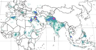 Do you notice anything missing? I see notable instances of clean, white, empty space in China, Burma, and Ethiopia, and near-white space in Iran. The sweep of Islamist violence depicted in the maps seems to flow up against the borders of these countries and then stop. Are there no Muslims in the countries involved? According to answers.com, Iran is 99% Muslim, Ethiopia is 47.5% Muslim, and Burma has 1,716,378 of them. China is harder to figure; it is only 3% Muslim, but that means it has more than 39 million of them, mostly Uighurs living in Xinjiang province, in the far west of the country. Ethiopia is a mystery to me — I know of no reason why it would be exempt from the Islamist violence that has plagued neighboring Eritrea, Somalia, and Sudan. Burma, aka Myanmar, is a military dictatorship which exerts strict control over all information flowing out of the country. There is undoubtedly Islamic violence in Burma — rumors to that effect occasionally emerge via refugees — but I can find no hard statistics. Undoubtedly, if all the facts were available, the sweep of blue and teal violence on the map would be continuous from Bangladesh across Burma and Thailand, jumping the straits to Malaysia and Indonesia. The Uighurs in China are immediately adjacent to Pakistan and Kashmir, regions which are among the most intensely colored on the map. Either the Chinese are very good at keeping a lid on their restive Muslim population, or, like Burma, they are simply preventing the news of the incidents from leaving the country. Iran, of course, is an Islamist theocracy. In a sense, every woman stoned for adultery and every student executed for blasphemy is a victim of Islamic terror. But that’s not the way the statistics are collected, so Iran is mostly white space. Imagine what would happen, however, if the mullahs were overthrown. Expect it to be like Iraq since the fall of Saddam — rival groups of Muslims using the car bomb and the suicide killer to attempt to impose their political will on each other, while a secular government tries desperately to establish a non-despotic authority. Wait and see the map after that happens! And this brings us to the map of Iraq. Look at the comparison of 2002 and 2005 in the maps on the right. In 2002, Saddam still had a monopoly on violence in his country, and the map of Iraq is free of color. All of the people maimed and shredded and poisoned and shot by Saddam’s thugs aren’t listed as victims of Islam, but simply as Saddam’s victims. Then look at 2005. The liberation of Iraq let loose the pent-up forces, and the diverse armies of the Prophet were free to have a go at each other, aided, abetted, funded, and led by opportunistic Islamist groups from outside the country. And one final comparison to make using these two maps: Israel in 2002 vs. Israel in 2005. The latter year still saw plenty of action by Palestinian shahids — the map of Israel is still completely colored in — but the severity of incidents is significantly less. Why do you think that might be? Something there is about a Palestinian terrorist that doesn’t love a wall. |
|
|
 Win a FREE Membership!
Sign up for the ARFCOM weekly newsletter and be entered to win a free ARFCOM membership. One new winner* is announced every week!
You will receive an email every Friday morning featuring the latest chatter from the hottest topics, breaking news surrounding legislation, as well as exclusive deals only available to ARFCOM email subscribers.

AR15.COM is the world's largest firearm community and is a gathering place for firearm enthusiasts of all types.
From hunters and military members, to competition shooters and general firearm enthusiasts, we welcome anyone who values and respects the way of the firearm.

Subscribe to our monthly Newsletter to receive firearm news, product discounts from your favorite Industry Partners, and more.
Copyright © 1996-2024 AR15.COM LLC. All Rights Reserved.
Any use of this content without express written consent is prohibited.
AR15.Com reserves the right to overwrite or replace any affiliate, commercial, or monetizable links, posted by users, with our own.