|
[#1]
Bought the garmin unit for one of my kids who is off the beaten track alot. I liked the text messaging capability just to check in, status updates. Plus you don't necessaruly have to call in the S and R team if it isnt life and death.
He also has a solar setup that is easily packable. The pay as you go is fine, he doesn't use it quite enough to justify an ongoing subscription. |
|
|
|
[#2]
My father uses a Garmin in reach to text me from the back country, it works great. Used to use a spot when they first came out. Was fine too.
That being said.. GARMIN. Last summer my father used his Garmin to have me kick of a search and rescue and for me to act as the liaison between the hikers in the back country and the rangers leading up the SAR operation as they were doing their thing. The garmin had excellent battery life and no issues connecting with satellites and was extremely reliable when it was needed. The incident lasted three days, and hours before they launched an all out operation the morning of the third day he self rescued.(old man had a senior moment in the back country compounded by a head injury) The garmin did its thing. |
|
|
|
[#3]
Garmin also just came out with an InReach mini. That + dedicated GPS or inReach + Goalzero if you are concerned about battery life.
I have used the inReach explorer+ and it works great. |
|
|
|
[#4]
I go solo backpacking quite often and my GF doesn't like it so I use the spot GPS. It works if you keep it updated and it is good for check ins etc.
I recently purchased a Ping device which i have been testing. It isn't as fast to pick up location like the Spot but it is 1/10th the size. I can track it in my car inside a parking garage. Two things I do not like about the Ping is it forces one to use the App for any function and the proprietary charging cable. Both work well and I am happy with both. |
|
|
|
[#5]
Quoted:
Garmin also just came out with an InReach mini. That + dedicated GPS or inReach + Goalzero if you are concerned about battery life. I have used the inReach explorer+ and it works great. This guy did a good review of the mini's features: Garmin InReach Mini Satellite Communicator In-Depth Review |
|
|
|
[#6]
Quoted:
Garmin also just came out with an InReach mini. That + dedicated GPS or inReach + Goalzero if you are concerned about battery life. I have used the inReach explorer+ and it works great. Any of the devices using the iridium satellites needs a clear line of sight to the satellites. That’s pretty much the big limitation. Most of my hikes are with a heavy canopy and it can be spotty in its 10 minute pings. Messages don’t send instantly. It’s good piece of mind for loved ones. The big reason I got one was so I could stay out longer without people at home worrying. |
|
|
|
[#7]
the garmin inreach doesn't currently replace a standard garmin gpsr. next year they are supposed to release such.
|
|
|
|
[#8]
Quoted:
the garmin inreach doesn't currently replace a standard garmin gpsr. next year they are supposed to release such. I have 4 western states of OnX maps, plus satellite imagery of frequently hunted locations loaded onto my Garmin 62SC. The land ownership data is worth it's weight in gold. IF they included that functionality in the Inreach, I would have bought it. I hunted Alaska last fall. I rented an InReach for 10 days for under $125, including the shipping to me and back. There are several reputable rental places. |
|
|
|
[#9]
Ya, a friend met with a Garmin rep at a conference this summer. The current Garmin inreach is almost exactly what inreach offered before the buyout. The next model is supposed to be what we all want - the gpsr features of a 62/64 combined with the satellite texting ability of the inreach. I'm recalling it was a "66" but I may be wrong. Form factor will be slightly bigger than a 64 and built in non-field changeable rechargeable battery- which I hate.
|
|
|
|
[#10]
My father is in MT and often goes out on back forest roads where you are a long way from cell coverage also riding around on a 4 wheeler out there.
I did some looking at the various units and went with the ResQlink buoyant model as what I got him for fathers day. Just seemed like overall it has the best reviews and is made by a company that specializes in those things. Just my .02 It seemed like a nice little unit. If I end up moving out that way I will be getting one for myself. |
|
|
|
[#11]
I rely on an ACR Personal Locator Beacon for ultimate emergency rescue request (for example: immobilzing injury, heart attack, severe burn, blindness, etc.) but not for informing family/friends of my whereabouts or status. This technology, so far as I know, is state-of-art "come and save me" gear... Have one, if your circumstances/situation might require one, and hope you never need it, like fire-extinguishers, bear-spray, 9mm pistols, and typewriters...
|
|
|
|
[#12]
I'd recommend the Garmin Inreach Mini and a separate GPS device. You won't be killing your comms battery when navigating. Definitely bring along a set of extra batteries and map and compass though! :)
|
|
|
|
[#13]
Quoted:
Ya, a friend met with a Garmin rep at a conference this summer. The current Garmin inreach is almost exactly what inreach offered before the buyout. The next model is supposed to be what we all want - the gpsr features of a 62/64 combined with the satellite texting ability of the inreach. I'm recalling it was a "66" but I may be wrong. Form factor will be slightly bigger than a 64 and built in non-field changeable rechargeable battery- which I hate. |
|
|
|
[#14]
Quoted: Garmin has the 66 up on their website and it is a regular GPSr powered by 2 AA batteries :) |
|
|
|
[#15]
I have the inReach. It's great.
|
|
|
|
[#16]
I don't have any of those but I was talking to a big game biologist the other day and he said they carry SPOT. These guys work, often alone, in some seriously remote places.
|
|
|
|
[#17]
Quoted:
I don't have any of those but I was talking to a big game biologist the other day and he said they carry SPOT. These guys work, often alone, in some seriously remote places. |
|
|
|
[#18]
I use the InReach.
I carry 3 devices in the back country 1) Garman etrex 30x *weatherproof *small *forever battery life *rugged 2) Samsung phone in airplane mode *great camera *waterproof *blutooth pairs to InReach for text messaging 3) Garmin (Delorme) InReach *I only turn it on 3 times a day to send/receive *basically use it as a repeater. Use Samsung phone to send/receive I go out for a week at a time. If it’s overcast and I can’t use a solar charger I can still make it a full week on a single phone charge if I use them sparingly. InReach easily makes it on one charge. The InReach is great because you can message anyone you want via text or email, and send any message you want, not just canned responses like Spot (maybe they changed that now?) |
|
|
|
[#19]
wow. lots of info to digest.
I was thinking about the SPOT, then decided to search arfcom, and found this thread. I was exploring this for a trip to S. America on motorcycle. rental seems too expensive.. maybe 30 days over 3.5-4 months. (~ 15 days there and back) |
|
|
|
[#20]
Get the Garmin, and bring one of those larger pocket battery banks to recharge from. Then while camped up or stalking use a goal zero pack solar panel to recharge the battery.
|
|
|
|
[#21]
I have the InReach Explorer+. The device, itself, works well for the most part. Though, the Iridium positioning can be prone to wildly inaccurate positioning when up against very large cliffs, but other than that, it's dependable … you, and anyone following your positioning, just need to be aware of this possible positioning problem … it can look like you've been hit by an avalanche.
The main problem, though, is with Garmin's website. It's an unmitigated disaster. They are very deceptive in their "system status" information. In the past 10 months, I've encountered no less than 3 website outages, and none of those 3 ever showed up as "down time" in their logs. If you buy a Garmin InReach do not wait until the night before a trip to sync, download maps, plot routes, et cetera. |
|
|
|
[#22]
I've had the InReach Explorer + for the past month. It works very well. Yesterday I had to reboot the device to get a test signal out, but that is the only time that has happened. The software is great for scouting because you can switch between satellite veiw and topo maps. The phone app is cool but has some quirks. Still, it works well overall. Delorme's background maps aren't the greatest. There have been minor variations between the background map and field terrain on occasion. All in all, the unit is a great asset to the outdoor adventurer. Piece of mind for solo trips is a good thing.
|
|
|
|
[#23]
Quoted:
I'd recommend the Garmin Inreach Mini and a separate GPS device. You won't be killing your comms battery when navigating. Definitely bring along a set of extra batteries and map and compass though! :) |
|
|
|
[#24]
I just bought a Garmin Inreach last week.
|
|
|
|
[#25]
anyone familiar with the Spot Gen3 service plan ?
their website says $199.99/YR or $19.99/MO (12 month term applies)  $199.99 or $239.88 ??? $199.99 or $239.88 ???
I only need service for 2, maybe 3 months out of 6. |
|
|
|
[#26]
You could always buy a actual plb.
The only issue with them is it's all or nothing when it comes to needing help. There are no monthly costs and to the best of my knowledge they work worldwide. If I were going to be out of country, way off the beaten path I would carry both. Here's a good write up. Another thing is in some countries sat comm's are illegal. For 99.9% of people that's not an issue but it's something to consider. |
|
|
|
[#27]
I bought an inreach last year for a hunting trip out west. It performed flawlessly.
|
|
|
|
[#28]
Did you look at the Delorme Inreach!?
Don't go for Garmin waste of money as the GPS sucks on it! Read many articles about it! Most say that they needed a second unit just to navigate! So why pay $400+ for a unit that does not work? The delorme inreach works for what your needing! Also saves you money! |
|
|
|
[#29]
While some sort of emergency communicator is a really good idea it's always a good idea to make sure someone knows roughly where you are.
When I was younger I would jump on my dual sport bike and head into the mountains for a few days at a time. If for some reason I didn't make it back nobody would have a clue where to start looking. There were a couple of times I got into some situations that could have ended very bad, put the bike into the pickers on a remote trail on a weekday and you can't self extract it the odds are you're either hiking out or waiting for someone else to pass by which in a lot of areas can be days. There are more than a few stories of people having to partially disassemble their bikes to get them back on the trail/road. I think the above type situation is where a device that you can both send and receive messages is perfect, not really an emergency but you need help of some sort. I have gotten wiser, now when I venture out to remote areas I let someone know what area I'll be in and who to contact if I don't come back when I'm supposed to. |
|
|
|
[#30]
Quoted:
Did you look at the Delorme Inreach!? Don't go for Garmin waste of money as the GPS sucks on it! Read many articles about it! Most say that they needed a second unit just to navigate! So why pay $400+ for a unit that does not work? The delorme inreach works for what your needing! Also saves you money! "DeLorme" devices will probably be used, as in 2016 Garmin bought DeLorme. |
|
|
|
[#31]
I have the inreach explorer plus with a low tier service plan. It's cheaper than spot, two way, has maps. Recently left it in my truck for a week. Forgot I had put it in there. Battery was at 80% and when I found it on a week later it still had 5% left. Think I had it set to check for messages every 10 minutes.
|
|
|
|
[#32]
Regarding the tracking off of the Iridium system vs conventional GPS constellations, I have noticed some positioning errors when I'm up against very large, steep cliffs.
Here's an example from my climb on Pinnacle Gully on Mt Washington last March. The positions in the highlighted box are bogus. I was on a 700 foot ice climb at the time. Never went over there. Glad the positioning didn't get spoofed to the SE, because it would have looked like an avalanche. 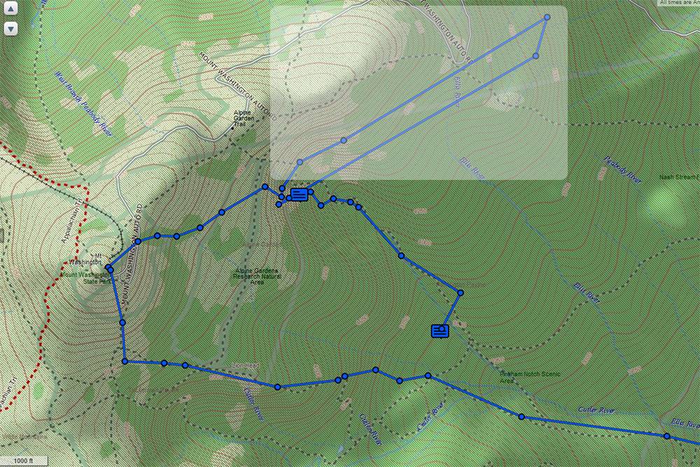
My actual path is shown in green ... 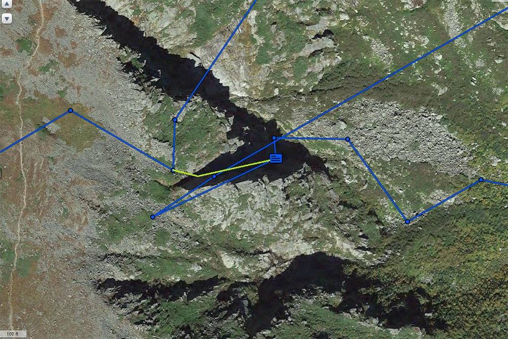
I also noticed a similar bogus transmission from Russian expedition currently on K2, also using Iridium tracking. There's a very large spoof on the green track, and a smaller, although somewhat more troubling spoof on the red track.... 
My InReach tracked fine in Manhattan, though. In open terrain, and in my hand, my InReach tracks very well, allowing me to recover my lost drone in a situation where everything else failed. Put me within 2 feet of the thing, and were it not for the InReach, I never would have found it based upon how it inverted into some emergent pines. Look, if you are on a 1000 foot vertical cliff, yes, the Iridium based tracking is prone to spoofing. You need to make sure that anyone following your tracks in real time understands this. And you, yourself, need to understand this, and check for this, if you have to signal for a rescue. And, this isn't limited to the Garmin/DeLorme InReach and Iridium satphones. Kate Matrosova's PLB sent out equally perplexing location spoofs when she activated her beacon when she got into trouble up on Mt Adams (near Mt Washington). I'm not sure exactly what she was using, other than it was not a Garmin/DeLorme. And, the spoofs were enough that rescuers backed off their first attempt and waited until morning to give it a second try. |
|
|
|
[#33]
I found this mentioned on another forum...
https://www.followmee.com uses your cell phone, so you need coverage for it to work. my trip to S.A. has data almost the whole way, transitioning the Darian Gap excepted. |
|
|
|
[#34]
You're driving the Darian Gap?
|
|
|
|
[#35]
Quoted:
You're driving the Darian Gap?  yeahhhhhhhhhhhh.no yeahhhhhhhhhhhh.nopanama > sailboat > cartagena |
|
|
|
[#36]
I was about to be really impressed. I read the book on the British Army expedition.
|
|
|
|
[#37]
Quoted:
I was about to be really impressed. I read the book on the British Army expedition. |
|
|
|
[#38]
Quoted:
Regarding the tracking off of the Iridium system vs conventional GPS constellations, I have noticed some positioning errors when I'm up against very large, steep cliffs. Here's an example from my climb on Pinnacle Gully on Mt Washington last March. The positions in the highlighted box are bogus. I was on a 700 foot ice climb at the time. Never went over there. Glad the positioning didn't get spoofed to the SE, because it would have looked like an avalanche. https://www.ar15.com/media/mediaFiles/203937/Map_03-502759.jpg My actual path is shown in green ... https://www.ar15.com/media/mediaFiles/203937/Map_04B-535396.jpg I also noticed a similar bogus transmission from Russian expedition currently on K2, also using Iridium tracking. There's a very large spoof on the green track, and a smaller, although somewhat more troubling spoof on the red track.... https://www.ar15.com/media/mediaFiles/203937/K2_2019_Russian_Attempt_-_1200-852202.jpg My InReach tracked fine in Manhattan, though. In open terrain, and in my hand, my InReach tracks very well, allowing me to recover my lost drone in a situation where everything else failed. Put me within 2 feet of the thing, and were it not for the InReach, I never would have found it based upon how it inverted into some emergent pines. Look, if you are on a 1000 foot vertical cliff, yes, the Iridium based tracking is prone to spoofing. You need to make sure that anyone following your tracks in real time understands this. And you, yourself, need to understand this, and check for this, if you have to signal for a rescue. And, this isn't limited to the Garmin/DeLorme InReach and Iridium satphones. Kate Matrosova's PLB sent out equally perplexing location spoofs when she activated her beacon when she got into trouble up on Mt Adams (near Mt Washington). I'm not sure exactly what she was using, other than it was not a Garmin/DeLorme. And, the spoofs were enough that rescuers backed off their first attempt and waited until morning to give it a second try. That being said I haven't experienced my position being wrong. |
|
|
|
[#39]
The current InReach units use the Iridium constellation for positioning. If you are on a steep mountain face, they will produce all sorts of erroneous positioning. The units are very useful, but this is something that users need to be aware of.
|
|
|
|
[#40]
Quoted:
The current InReach units use the Iridium constellation for positioning. If you are on a steep mountain face, they will produce all sorts of erroneous positioning. The units are very useful, but this is something that users need to be aware of. I was on forever, and still didn't get to talk to anyone, but while I was waiting, I did see that they mention having a GPS receiver, in one of the on-line resources I was looking at... but nothing definitive. Positioning info is possible using the Iridium networks LBS (Location Based Services) channel. I tried to send an email to Garmin support, but their captcha thingy just spins...  maybe I'll try calling again tomorrow. |
|
|
|
[#41]
Quoted: I was on hold with garmin today to get a solution to "is it real GPS?" I was on forever, and still didn't get to talk to anyone, but while I was waiting, I did see that they mention having a GPS receiver, in one of the on-line resources I was looking at... but nothing definitive. Positioning info is possible using the Iridium networks LBS (Location Based Services) channel. I tried to send an email to Garmin support, but their captcha thingy just spins... maybe I'll try calling again tomorrow. |
|
|
|
[#42]
Or just, ya know, use the GPS receiver in yer phone to get a near exact position?
|
|
|
|
[#43]
Quoted:
Or just, ya know, use the GPS receiver in yer phone to get a near exact position? |
|
|
|
[#44]
Quoted:
I was on hold with garmin today to get a solution to "is it real GPS?" I was on forever, and still didn't get to talk to anyone, but while I was waiting, I did see that they mention having a GPS receiver, in one of the on-line resources I was looking at... but nothing definitive. Positioning info is possible using the Iridium networks LBS (Location Based Services) channel. I tried to send an email to Garmin support, but their captcha thingy just spins... maybe I'll try calling again tomorrow. Quoted:
Quoted:
The current InReach units use the Iridium constellation for positioning. If you are on a steep mountain face, they will produce all sorts of erroneous positioning. The units are very useful, but this is something that users need to be aware of. I was on forever, and still didn't get to talk to anyone, but while I was waiting, I did see that they mention having a GPS receiver, in one of the on-line resources I was looking at... but nothing definitive. Positioning info is possible using the Iridium networks LBS (Location Based Services) channel. I tried to send an email to Garmin support, but their captcha thingy just spins... maybe I'll try calling again tomorrow. I suspect because the Iridium satellites are in a lower orbit, this is what causes the problems in triangulation in steep terrain. The lower orbits are, however, needed to reduce the xmit requirements of the units. The Explorer+ has a lot of great features, but it seems to lack the ability to tag a location as a waypoint to which you can nav to. There might be some workaround in the "routes" option in the PC interface, but you can't do that in the field. You can, however, move the cursor to a spot and then nav to it, but that not as robust as being able to set and store these points on the fly. Now, you can mark waypoints … once you are there … but I think it would be nice to be able to tag a remote location. I think you can do this with other Garmins. For serious land nav, the other Garmins have better features than the Explorer and Explorer+. Perhaps an InReach Mini and top end eTrex is a better combo for serious land nav? But, you are definitely going to need a functioning phone if you need to do any non cookie cutter communication with the InReach Mini. At least with the Explorer/Explorer+, I can type out any message I need to with that unit, even without BlueToothing to my phone. |
|
|
|
[#45]
Quoted:
Which will also be prone to error in the same conditions, but owing to slightly different reasons. Quoted:
Quoted:
Or just, ya know, use the GPS receiver in yer phone to get a near exact position? |
|
|
|
[#46]
|
|
|
|
[#47]
Quoted:. Yer phone isn't going to be contacting the iridium satellites to have someone bail you out either. The backcountry is big, but the inreach is going to put searchers in the neighborhood if needed. The phone I'm on now puts me on my lot while I'm inside the house on the bottom floor. Sounds a bit more accurate than an Iridium position. |
|
|
|
[#48]
Quoted:
No, but your phone will give you coordinates from a more accurate satellite constellation. You can manually type in the GPS coordinates from your phone into your satellite communicator. The phone I'm on now puts me on my lot while I'm inside the house on the bottom floor. Sounds a bit more accurate than an Iridium position. Quoted:
Quoted:. Yer phone isn't going to be contacting the iridium satellites to have someone bail you out either. The backcountry is big, but the inreach is going to put searchers in the neighborhood if needed. The phone I'm on now puts me on my lot while I'm inside the house on the bottom floor. Sounds a bit more accurate than an Iridium position. Cell phones and other devices have aperture designs that make a lot of compromises for the sake of compact packaging. Dedicated GPS units generally adopt bulkier packaging for the sake of better apertures. You can't compare the RF environment of your house to that of a couloir on a large mountain. At the moment, my InReach doesn't just show me to be on my property, but it actually shows what room I'm in. I routinely travel in the backcountry with an InReach Ex+, Motorola cell phone equipped with Earthmate, and DJI drone. On multiple occasions in the backcountry, my DJI failed to function because it was unable to get a GPS signal (Navstar, GLONASS, and so forth). And my phone was unable to get sufficient positioning to satisfy DJI's geofencing safeguard. I've even had one really bad flyoff when operating in a deep gorge. Meanwhile, my InReach Ex+ gave more accurate positioning using the Iridium constellation than the other devices using Navstar/GLONASS. ... Because InReach offers real time tracking, users need to be aware that in some conditions involving massive earth obstructions can cause erroneous positioning - if you have somebody following you who is in a position to call out the cavalry if they think you've been injured, you need to give them a primer on what type of erroneous stuff they might notice and how to verify a bogus position. There is a world of difference between looking at a static map and looking at real time data. |
|
|
|
[#49]
Here is another example of InReach Ex+ tracking in steep terrain in Virginia. The tracking was quite good, but if I look a the 1 minute tracks, the error becomes more noticeable. The tracking you see is 10 minute tracking. And what you'll notice is that there are gaps greater than 10 minutes in some spots. The terrain is somewhat steep, but it never bottlenecks and there are few vertical sections.
Now, in this same terrain, I cannot get a sufficient GPS signal (Navstar/GLONASS) to operate my DJI drone up on this trail. I can get it to partially function from the parking lot, but even then, it's sketchy. [The ascent is directly up the waterfall. The descent is via the trail.] 
|
|
|
|
[#50]
All consumer grade GPS tracking stuff is going to have issues when you're in mountainous or heavily treed areas.
I often will record my tracks when I'm on my bike or in my Jeep and almost always there will be a spot or two where it loses signal for a bit when I'm in the mountains which results in a straight line in my track. |
|
|
 Win a FREE Membership!
Sign up for the ARFCOM weekly newsletter and be entered to win a free ARFCOM membership. One new winner* is announced every week!
You will receive an email every Friday morning featuring the latest chatter from the hottest topics, breaking news surrounding legislation, as well as exclusive deals only available to ARFCOM email subscribers.

AR15.COM is the world's largest firearm community and is a gathering place for firearm enthusiasts of all types.
From hunters and military members, to competition shooters and general firearm enthusiasts, we welcome anyone who values and respects the way of the firearm.

Subscribe to our monthly Newsletter to receive firearm news, product discounts from your favorite Industry Partners, and more.
Copyright © 1996-2024 AR15.COM LLC. All Rights Reserved.
Any use of this content without express written consent is prohibited.
AR15.Com reserves the right to overwrite or replace any affiliate, commercial, or monetizable links, posted by users, with our own.