|
[#1]
tag
|
|
|
|
[#2]
and for me too - I'd be curious to see if anyone has experience with one for hiking...
|
|
|
|
[#3]
Garmin eTrex Venture HC. Has a color screen. $125.00. I set waypoints where ever I travel. Links to satellites very fast.
Garmin Venture HC |
|
|
|
[#4]
I recently picked up a Garmin GPSmap 60CSx and I like it.
Quoted:
and for me too - I'd be curious to see if anyone has experience with one for hiking... I haven't hiked with mine but I did use it to plot the property line on a couple pieces of land. I was able to add the topo info for the areas as well. Worked pretty slick. |
|
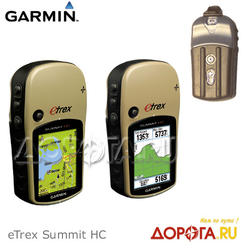
|
|
[#5]
Quoted: Garmin eTrex Venture HC. Has a color screen. $125.00. I set waypoints where ever I travel. Links to satellites very fast. Garmin Venture HC +1 It has limited memory, but that has never been a problem for me. It had enough memory for maps of most of Oklahoma and if I plan on being out of state I can just load the map I need. |
|
|
|
[#6]
http://www.garmin.com/garmin/cms/site/us
I have an etrex legend. Works great for geocaching. BTW. GEOCACHING.COM!!! Very addictive sport. If I had the moolah, I'd get the 60csx. |
|
|
|
[#7]
I use a eTrex Vista HCx
I got it to replace the Legend C that had a problem with the usb interface. I'd go with anything made recently by Garmin, stay away from everything else (unless its a Topcon or Trimble) |
|
|
|
[#8]
I have a garmin rino (it has a really powerful 2 way radio to go with the color screen GPS)
|
|
|
|
[#9]
Garmin Foretrex 101.
$120, you wear it on your wrist, 50 waypoints, x3 AAA batteries, on-command illuminated. |
|
|
|
[#10]
Look up the delorme handheld gps. They look really nice plus the best part the come with topo built in. And for only thirty bucks a year you can down load any maps you want. Including nautical , satellite imagery , street , usgs survey maps. That alone would cost hundreds of dollars from garmin
Posted Via AR15.Com Mobile I've been looking at buying a gps for a long time. my dad has a garmin but he paid I think 400 for it then had to pay another 100 bucks for topo us. only to find out he now has to pay another 100 bucks for Canada.. screw that I'm buying this Delorme PN-30 its over your budget but you might as well do it right the first time instead of buying something cheap and hating your self later |
|
|
|
[#11]
Quoted:
I recently picked up a Garmin GPSmap 60CSx and I like it. Quoted:
and for me too - I'd be curious to see if anyone has experience with one for hiking... I use my 60CSx for hiking the Florida and Appalachian Trails. In fact I'm in the process this week of working up the tracks for another AT hike. I love the 60. I'd say I use it less for navigation and more for tracking time/distance and recording key waypoints (namely water sources and potential camping sites but also scenic views and things like that). The trails are pretty well marked so I don't worry too much about navigation. I also carry USGS maps and hand plot as well. Too bad it's out of the OP's $ range. |
|
|
|
[#12]
Just bought a new Garmin eTrex LEgend H last saturday. I had one before but it got stolen. This is a kick ass little item for $125.00 at best buy right now. Its on closeout.

|
|
|
|
[#13]
garmin 60csx or 60cx series
/thread |
|
|
|
[#14]
Quoted: With the exception of spoken directions, this will do everything you need in an outdoor GPS, and make a fair substitute for an in-car GPS navigation system. You have the option to change maps by swapping micro SD cards, so you can load up city and highway maps with waypoints and POIs for travel, or load up topo maps for hiking/hunting.garmin 60csx or 60cx series /thread The autorouting capability functions just like an in-car system and will tell you when to turn, etc. with audible beeps and on screen indicators. Really, if you want one GPS that will do it all, the 60csx is the one to get. They have come down about $150 in price since I bought mine. They are $350 in Cabelas fall catalog. |
|
|
|
[#15]
Quoted:
Quoted:
I recently picked up a Garmin GPSmap 60CSx and I like it. Quoted:
and for me too - I'd be curious to see if anyone has experience with one for hiking... I use my 60CSx for hiking the Florida and Appalachian Trails. In fact I'm in the process this week of working up the tracks for another AT hike. I love the 60. I'd say I use it less for navigation and more for tracking time/distance and recording key waypoints (namely water sources and potential camping sites but also scenic views and things like that). The trails are pretty well marked so I don't worry too much about navigation. I also carry USGS maps and hand plot as well. Too bad it's out of the OP's $ range. RIF. Missed the price range in the OP. |
|
|
|
[#16]
Garmin Vista HCx
|
|
|
|
[#17]
Garmin eTrex Legend Cx. Got mine refurbished on Ebay for $120 then picked up a multi-state 24K Topo map Micro SD card for $75.
Tomac |
|
|
|
[#18]
How about an iPhone?
No, I'm serious. I'm looking at buying one in the next 6 weeks or so, and I've been impressed so far with its navigation capabilities. I took a 5-hour trip with a coworker, and it gave better directions than my in-car system.
|
|
|
|
[#19]
Quoted:
Quoted:
I recently picked up a Garmin GPSmap 60CSx and I like it. Quoted:
and for me too - I'd be curious to see if anyone has experience with one for hiking... I use my 60CSx for hiking the Florida and Appalachian Trails. In fact I'm in the process this week of working up the tracks for another AT hike. I love the 60. I'd say I use it less for navigation and more for tracking time/distance and recording key waypoints (namely water sources and potential camping sites but also scenic views and things like that). The trails are pretty well marked so I don't worry too much about navigation. I also carry USGS maps and hand plot as well. Too bad it's out of the OP's $ range. It was out of my price range when I posted this same question a year and a half ago. I got so may thumbs up for it I sucked it up and bought one. It's an awesome unit. I've used it on heavily canopied trails and never lost a signal. I've also used it with City navigation and on the Chesapeake Bay. In addition to City navigator I also have Topo 24K |
|
|
|
[#20]
Quoted:
How about an iPhone? No, I'm serious. I'm looking at buying one in the next 6 weeks or so, and I've been impressed so far with its navigation capabilities. I took a 5-hour trip with a coworker, and it gave better directions than my in-car system. does it use GPS signals or triangulation from cellular towers?. if not, you get off the beaten path and that location feature on your iPhone will become useless |
|
|
|
[#21]
Quoted:
Look up the delorme handheld gps. They look really nice plus the best part the come with topo built in. And for only thirty bucks a year you can down load any maps you want. Including nautical , satellite imagery , street , usgs survey maps. That alone would cost hundreds of dollars from garmin Posted Via AR15.Com Mobile I've been looking at buying a gps for a long time. my dad has a garmin but he paid I think 400 for it then had to pay another 100 bucks for topo us. only to find out he now has to pay another 100 bucks for Canada.. screw that I'm buying this Delorme PN-30 its over your budget but you might as well do it right the first time instead of buying something cheap and hating your self later Damn, that looks nice, wish I had seen that when i was shopping for GPS units last fall... |
|
|
|
[#22]
tag
|
|
|
|
[#23]
I like the Garmin eTrex's. I had a Vista for about 4 years, and just recently lost it. Rugged little bastard. It took the beating and saltwater drenching in stride. Epic battery life. I replaced it with a Vista Cx the other day that I found on craigslist ($100)
On topo maps: 1:100,000 scale is absolutely worthless for hiking––of zero value whatsoever. You need 1:24,000 if you get any maps at all. |
|
|
|
[#24]
I use this, and it has served me well.
|
|
|
|
[#25]
Quoted: How about an iPhone? No, I'm serious. I'm looking at buying one in the next 6 weeks or so, and I've been impressed so far with its navigation capabilities. I took a 5-hour trip with a coworker, and it gave better directions than my in-car system. I get HORRIBLE reception on my iphone, I can't even get a signal at my house, nevermind in the middle of the woods miles out. |
|
|
|
[#26]
IF you get an eTrex, make sure it's one of the models with an H and and x in the model number.
the H is higher sensitivity ( much better than the models w/o) the x is for the microSD card capabilities. (and you WILL need this feature as the on-board memory is limited) eta: heck, might as well make sure you get the HCx, the C, for Color, you'll want that too, makes things much more easier to read |
|
|
|
[#27]
Quoted:
I recently picked up a Garmin GPSmap 60CSx and I like it. Quoted:
and for me too - I'd be curious to see if anyone has experience with one for hiking... I haven't hiked with mine but I did use it to plot the property line on a couple pieces of land. I was able to add the topo info for the areas as well. Worked pretty slick. I hike , kayak, and drive with mine. It is awesome. The double helix antenna picks up signals under heavy growth, canyons and inside the basement of my house. I bought mine at REI and was sold after it was obvious it was the only one to give a position inside the damn store. |
|
|
|
[#28]
Quoted: Quoted: How about an iPhone? No, I'm serious. I'm looking at buying one in the next 6 weeks or so, and I've been impressed so far with its navigation capabilities. I took a 5-hour trip with a coworker, and it gave better directions than my in-car system. does it use GPS signals or triangulation from cellular towers?. if not, you get off the beaten path and that location feature on your iPhone will become useless My understanding is that it uses both. True GPS get you within a few dozen feet, while triangulation gets it close enough for turn-by-turn. I realize it won't be the best GPS device out there, but I'm wondering if it won't be adequate. I'll find out in about 6 weeks.
|
|
|
|
[#29]
230,
The outdoor models work very similar to the one in your rig. One thing to consider is that buying GPS units, like many things electronic, can be a little frustrating. All models have basic features, and a little more money gets you a few more features. It's hard to know exactly what you want. I have been GPSing here at work and at play since the early days of GPS, and you can't go wrong with one of the basic Garmin E-Trex units. They are very small, and are easily used on the trail. You can slip them in your pocket, clip them on your pack, whatever. The instruction book is easy to understand, and the menus on the unit are very intuitive. I really put them through some serious abuse between my work and play, and they hold up well. Even the little rubber covered rocker arm. A lot of the mapping features being mentioned are really cool, if you get into the gpsing. If you want basic feature they are not needed. But I gotta warn you, once you start, they can become pretty addicting. The good news is that even if you decide to upgrade down the road, I bet you know someone who would love to get started with a basic unit. Craig |
|
|
|
[#30]
I want one too but don't know where to start. From this thread looks like I'll look at Garmin.
I want it for going out in the woods on an ATV. I seen a couple of you talking about setting 'way points'. That's great. Can you also record your path? I have tons of paths on the woods and would like to map them. Do these units do that? You also talked about maps. Do they just come with a blank screen or what? What else do you have to buy? Can this stuff be downloaded? Can you use the outdoor one as a street map also? How do you go about that? |
|
|
|
[#31]
Quoted: I want one too but don't know where to start. From this thread looks like I'll look at Garmin. I want it for going out in the woods on an ATV. I seen a couple of you talking about setting 'way points'. That's great. Can you also record your path? I have tons of paths on the woods and would like to map them. Do these units do that? You also talked about maps. Do they just come with a blank screen or what? What else do you have to buy? Can this stuff be downloaded? Can you use the outdoor one as a street map also? How do you go about that? most all units come with a base map.. not that great.. good enough to use the basic features, like keep track of a heading or ability to mark a location. some come with additional maps (topo and/or road) or they can be purchased separately (highly recommended) all the garmin's I've used allow you to log your track(s) for download when you get home or use in the unit itself (I like using mine for this feature, particularly when I ride my bike or on my dirtbike.) you can view your tracks on the Garmin software and even export them to Google Earth, which is really cool. |
|
|
|
[#32]
Quoted:
garmin 60csx or 60cx series +1 on the Garmin 60csx...you might as well spend the extra money and get something that has the features this one has. I use a 60csx in my vehicle and when walking in the woods. I also have a Garmin V mounted on my ATV. Neither one has ever given me a problem....good stuff. |
|
|
|
[#33]
60csx
|
|
|
|
[#34]
tag
|
|
|
|
[#35]
There are likely some nice ones out there.
I'd still advise learning how to read topomaps, possibly mil grid maps...and, learning how to read a compass. |
|
|
|
[#36]
I have a venture hc and have a vista hcx on the way. The vista is factory refurbished and was much less expensive. I'll post a AAR next week. Meanwhile here are a few of the maps I have made for my hunt club:
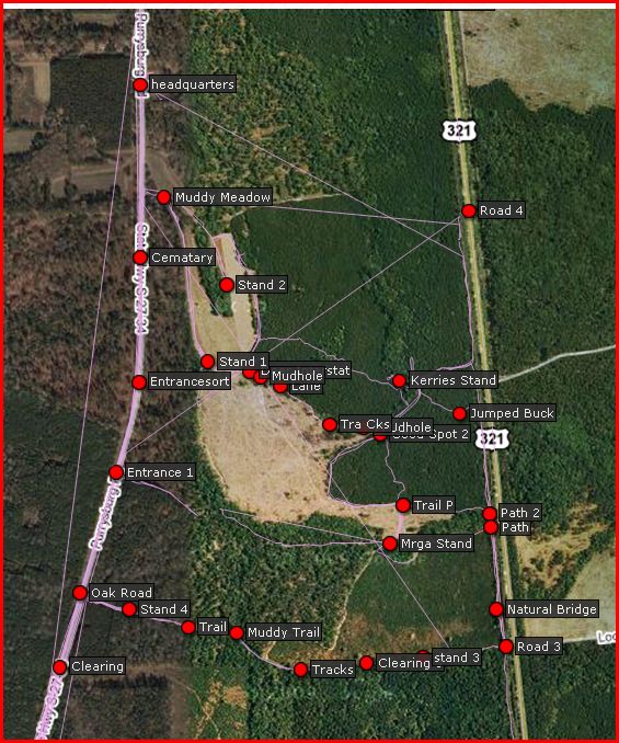
My printed maps are larger and I have differant ones, depending on how much detail is in the area we are in 
The long straight lines are where the track log was interupted and it just connected to the next location. When we are scouting I mark anything of interest. I can track a hog or bushwack to the nearest stand easily. |
|
|
|
[#37]
Quoted: I have a venture hc and have a vista hcx on the way. The vista is factory refurbished and was much less expensive. I'll post a AAR next week. Meanwhile here are a few of the maps I have made for my hunt club: http://farm3.static.flickr.com/2492/3917233344_d237a69ff5_o.jpg My printed maps are larger and I have differant ones, depending on how much detail is in the area we are in http://farm3.static.flickr.com/2573/3916445731_d3958ef36a_o.jpg The long straight lines are where the track log was interupted and it just connected to the next location. When we are scouting I mark anything of interest. I can track a hog or bushwack to the nearest stand easily. Do you pay extra for Google Earth interface to the GPS? (for those that don't know, the dots are waypoints, the lines are tracks––a breadcrumb trail). Waypoints can also be uploaded or typed into the unit (you don't have have ever actually been there). ETA: One of my stupidest moments this summer was losing a GPS. |
|
|
|
[#38]
Quoted:
I want one too but don't know where to start. From this thread looks like I'll look at Garmin. I want it for going out in the woods on an ATV. I seen a couple of you talking about setting 'way points'. That's great. Can you also record your path? I have tons of paths on the woods and would like to map them. Do these units do that? You also talked about maps. Do they just come with a blank screen or what? What else do you have to buy? Can this stuff be downloaded? Can you use the outdoor one as a street map also? How do you go about that? I am upgrading to the vista mainly so I can have 20 "tracklogs". Be sure and spend some time getting to know your unit and working with it. I know a couple of guys that only look at the map and active track. They are cheating themselves by not learning the few basic functions that are the most useful. When you are pricing make sure the unit comes with a cord. Some of the lesser expensive ones do not, and it's pretty useless if you cannot hook it up to your computer. See my map? Those stands and other dots are "waypoints". The names are funny because you have to have a unique name for each one and you are limited (with mine anyway) to a certain number of characters. The other lines are trails we have walked and bushwacked. I tried to make a nice "clean" map with little or no backtracking but it didn't work out. When I go to a new area I save that tracklog. Sometimes I have gone to old areas to so my maps look a little messy. I have a strategy now so maybe I can make some new better maps. but to tell the truth, my maps serve their purpose. Also, look into recharable batteries. I have 2 chargers, a lacrosse and a maha. My favorite batteries are eneloops and sanyo 2700's. I get them from here. I can use my headlamps, camera, and gps's to my hearts content, I always have batteries. No sense having nice things if you can't use them the way you want to. |
|
|
|
[#39]
Do you pay extra for Google Earth interface to the GPS? (for those that don't know, the dots are waypoints, the lines are tracks––a breadcrumb trail). Waypoints can also be uploaded or typed into the unit (you don't have have ever actually been there). ETA: One of my stupidest moments this summer was losing a GPS. You do not have to pay for google earth. I make my maps either in mapsource, which garmin usually provides with the gps, or this website which totally kicks ass!!!11 I use easy gps to export my track files, it's free, and then go to that website to make the map. Then to print it I use the screen snip feature in vista to make a .jpg. I'm sure there are many ways to make a map but those are the onlly ones that have worked for me. Plus the information is always available on the gps. My venture hc can save 10 tracks. I can select which ones will be displayed on the map at any given time. I don't always have them all displayed because my tracklogs are rather cluttered, sometimes it's just easier if I see just the path to my stand for instance. Now even when you are displaying a path (it's called a "track"), you can still watch your active tracklog. This is the electronic bread crumb trail the gps records. You can turn this on or off. You can also clear it. I have started doing this: I leave it on all the time, but when I go to a new area I clear it and sometimes my other trip data. That way I can save the shiny new track and when I add it to my map I don't get all the lines. There are a few things to know about a handheld gps. For one, it's only accurate when you are moving. Some of them have an electronic compass to help with the standing still thing but it's not like a real compass so don't rely on it like one. A gps is only so accurate, and this changes from day to day, or even minute to minute, depending on the satillites. So if you are following a track of a trail that you saved, and you look at the active track long, the lines may not coincide, even if you walk on the exact same spot. If you stick it in your pocket it might lose a signal. My venture has a clip that I can clip to a backpack strap but I kind of made it out of nokia stuff. I have a case for my new vista but it has a flap that covers up the top where the sensor is. This bothers me. I will note this in my AAR when I get my vista. this website will help you with the basics. |
|
|
|
[#40]
I had a first gen. Vista a few years back when I was into Geocaching, and it worked well. The newer ones are much nicer and priced better. (Color screen, better memory storage, USB port). The older models used a serial port, which many modern laptops do not have, and so require you to get a USB to serial converter. Still, not a problem with current models made in the last 4 or 5 years.
I now have a 60csx. I love the larger screen. It also has an external quad helix antenna that gets better reception in dicey areas thatn the etrex series' patch antennas, the compromise being possibly a little positional accuracy. The 60 models also have an external antenna port, autorouting capability, a 3D road view for car use, proximity alerts, and dedicated geocaching features. I'm not familiar with the new Vista's firmware, so I can't make a comparison there. But price-wise, the only real sacrifice you make by choosing the vista over the 60 is the screen size and autorouting. Neither of which is really necessary for most outdoor use. Although, the 60's larger screen size helps if you use it like I do, mounted on my ATV. I have my map data fields set up to give me speed in MPH since my ATV doesn't have a speedometer, and time of sunset, so I know when to head in. With a 1 gig micro SD card, I have all of Utah in USTOPO loaded, and city select as well for road use if I ever need it. (I have a Nuvi for the car, so I never use the 60 in there.) Cool thing about the Nuvi is you can use USTOPO on there as well, but you can't manually enter lat/lon to navigate to. You can still save waypoints, however. So if someone has a Garmin in-car GPS, they can still get a bit of outdoor utility out of it. |
|
|
 Win a FREE Membership!
Sign up for the ARFCOM weekly newsletter and be entered to win a free ARFCOM membership. One new winner* is announced every week!
You will receive an email every Friday morning featuring the latest chatter from the hottest topics, breaking news surrounding legislation, as well as exclusive deals only available to ARFCOM email subscribers.

AR15.COM is the world's largest firearm community and is a gathering place for firearm enthusiasts of all types.
From hunters and military members, to competition shooters and general firearm enthusiasts, we welcome anyone who values and respects the way of the firearm.

Subscribe to our monthly Newsletter to receive firearm news, product discounts from your favorite Industry Partners, and more.
Copyright © 1996-2024 AR15.COM LLC. All Rights Reserved.
Any use of this content without express written consent is prohibited.
AR15.Com reserves the right to overwrite or replace any affiliate, commercial, or monetizable links, posted by users, with our own.