|
[#1]
Woke me up this morning. Some pretty good shaking in the area..
|
|
|
|
[#2]
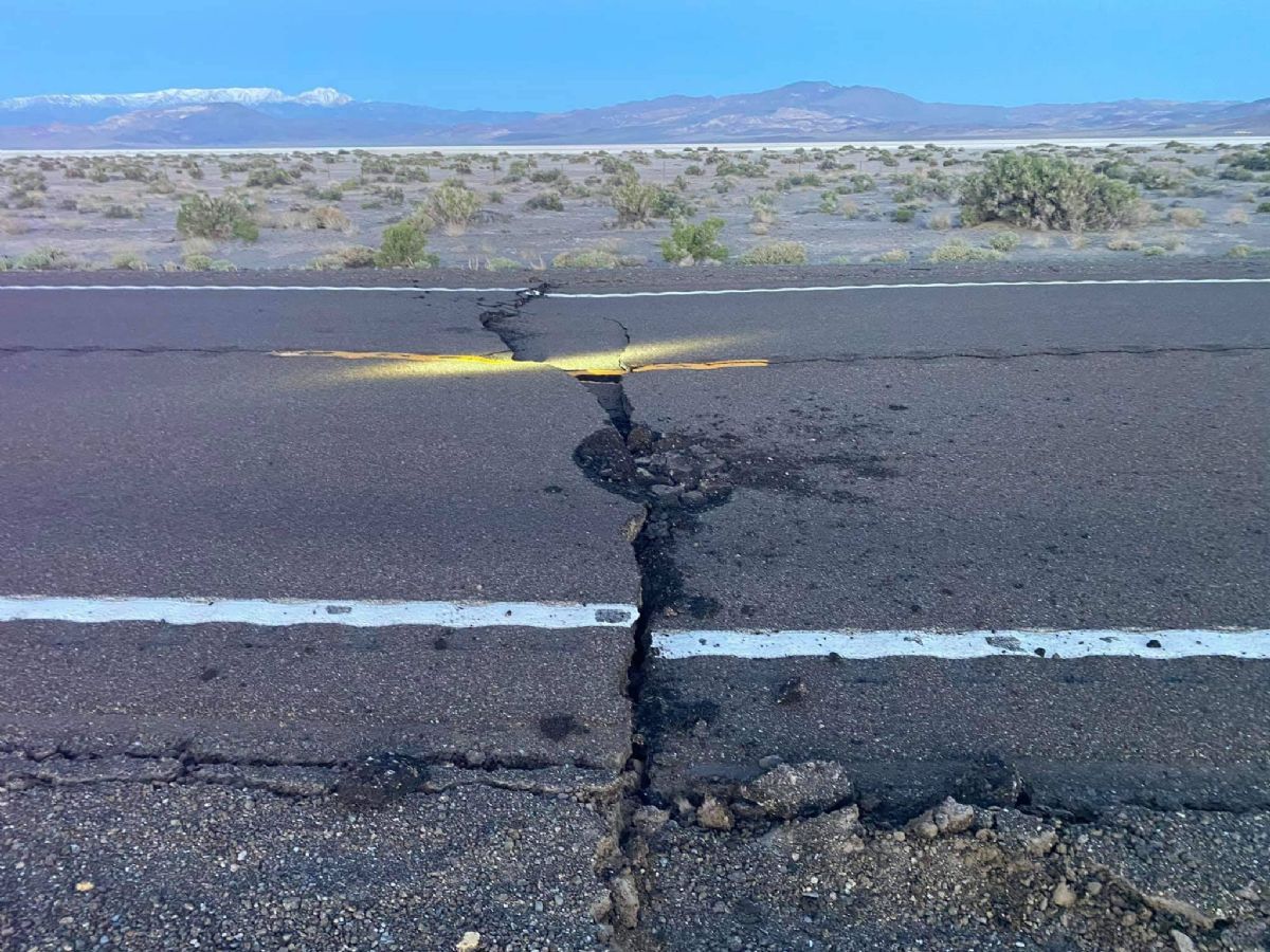
Damage also reported to Highway 360. A detour using Hwy 360 is being established.
|
|
|
|
[#3]
|
|
|
|
[#4]
I check the southern California earthquake data center daily, they show epicenter at 48 miles ese Hawthorne, 36 west of Tonopah, upgraded to 6.5.
|
|
|
|
[#5]
Stolen from Esmeralda Co Sheriff's facebook page.
|
|
|
|
[#6]
Felt it all the way over here in Carson City, about 4:05. Thought it was a lot closer !
|
|
|
|
[#7]
Any damage to the road to Montgomery Pass?
Nope. In fact rt 360 was the detour. 95 closed for about 10 hours and was repaired and reopened. |
|
|
|
[#8]
Felt it in NLV. felt it on the second floor, wife didn't notice downstairs. pool was making some waves.
|
|
|
|
[#9]
Felt it in Reno.
|
|
|
|
[#10]
Some trivia; that picture is looking West and the snow covered peak on the right is Boundary Peak. The California/Nevada state line passes between the two summits and descends to the left on the near side of the range so most of the snow covered range in the rear left is in California.
Edit, wrong quote. |
|
|
|
[#11]
I was in the Reese River Valley maybe 80 miles from the epicenter. Shook the shit out of our tent trailer!
|
|
|
|
[#12]
What’s interesting is the way the cracks spiderweb around the area. I assumed there would be a rift across the highway continuing east and west. Instead, the area shows cracks but the big shift pictured is 1-200 yards N/E and roughly parallel to the highway.
Some pictures from yesterday morning, hope this works. |
|
|
|
[#13]
Wow that’s wild!
|
|
|
|
[#14]
I went into the Monti Cristo's today. Esmeralda County was blading the road. I rode in 6 or 8 miles and didn't notice any rock falls or evidence of any kind of the quake. I met a guy that was camped at the mouth of the canyon, he said the 5.0 yesterday shook his pickup. He said the epicenter was a few hundred yards from his camp site. When I came out of the canyon he said he had felt another 3.5. Then I drove out and looked at the site of the damage to the highway. It is surprising how little disturbance there was to the ground from such a large shaker. Lucky it wasn't any closer to Tonopah.
|
|
|
|
[#15]
Felt another, my internet connection was down for a bit, I just checked a 5.3 at 17:22. Lots more micro quakes since.
|
|
|
|
[#16]
Thanks for the pics @Arlis. Geology is fascinating.
|
|
|
|
[#17]
My pleasure. I don’t have a link yet but a friend told me about a geologist that put up a drone and took some very interesting pictures over the dry lake bed. I also stopped in Coaldale yesterday and saw surface cracking there 5 miles away. There is another small highway repair done in the area now. I think there have been two subsequent quakes over magnitude 5 since the big one and with the dozens of aftershocks this may not be over. I also understand that there are three volcanic calderas in the region and those raise the stakes. 2020 could be interesting
  5/15/2020 -- Very large M6.5 Earthquake strikes California / Nevada border at volcanic field |
|
|
|
[#18]
Interesting day. In coaldale area, apparently hundreds of quakes, dozens of which were magnitude 2.5 or higher and the only one I felt was the 4.0. The bumps on the highway felt worse on the way back than the way out though so that’s something.
|
|
|
|
[#19]
I got an alert for a 4.0 and a 4.2 near Mina earlier today. Didn't see the others though since they were below the threshold to trigger my warnings.
|
|
|
|
[#20]
This site shows activity for the region. Click on the event and you can use the interactive shake map to see what magnitude was felt at the different distances outlined.
https:scedc.caltech.edu//recentMaps//118.38:html |
|
|
|
[#21]
4.2 about an hour ago in the same area.
|
|
|
|
[#22]
5.1 @ 02:24 6/30/2020. Same area.
|
|
|
 Win a FREE Membership!
Sign up for the ARFCOM weekly newsletter and be entered to win a free ARFCOM membership. One new winner* is announced every week!
You will receive an email every Friday morning featuring the latest chatter from the hottest topics, breaking news surrounding legislation, as well as exclusive deals only available to ARFCOM email subscribers.

AR15.COM is the world's largest firearm community and is a gathering place for firearm enthusiasts of all types.
From hunters and military members, to competition shooters and general firearm enthusiasts, we welcome anyone who values and respects the way of the firearm.

Subscribe to our monthly Newsletter to receive firearm news, product discounts from your favorite Industry Partners, and more.
Copyright © 1996-2024 AR15.COM LLC. All Rights Reserved.
Any use of this content without express written consent is prohibited.
AR15.Com reserves the right to overwrite or replace any affiliate, commercial, or monetizable links, posted by users, with our own.