|
[#1]
Quoted: I am planning on taking my family to Big Bend in November for some outdoor recreation, I have a new jeep build that should be done by then and figured it would be a good way to put some miles on it. We are most likely going to rent a house in Terlingua. I have lived in Texas since birth but have never been out /down there. Does anyone have any pointers on the dos and donts? Do any of the cellphone companies work there? Dont leave valuables in your car if you go on a hike. Do bring plenty of water. temp can vary 40+ degrees in different areas of park. Cell is sporadic, but worked consistently in Chisos Mountain area. Get reservations now if you want lodging or campsites. Bring a passport or passport card if you want to border cross (closed now, but might be open in fall). Bring a bathing suit if you want to go in the springs. dont bring firearms into buildings. The chili cookoff is in 11/3 - 11/6, good time to avoid the area. |
|
|
|
[#2]
Plenty of food/water. My last trip there was in December. We saw 20s in the Chisos and 80s in the low country. The easier to get areas can get busy, but the true gems of the park are off the beaten path.
Mentioning your Jeep, I assume you'd be interested in some of the primitive roads. My favorite part of my last trip was driving Black Gap at sunrise. We didn't see another person until we reached Mariscal mine. Be sure to have means of changing/fixing flats due to the rocks. I drove this in an F250 on 35s, so your Jeep shouldn't have any issues. Obviously, carry everywhere due to border proximity. Black Gap looking toward the Chisos. I believe that's Elephant Tusk right over my truck. Mariscal Mine. Planned route was marked in blue, actual route in red. Old Ore road was closed at the time due to a rolled Unimog, hence only the south portion being completed. Feel free to ask any questions. I've been there a few times. It's one of my favorite National Parks. |
|
|
|
[#3]
Quoted: Plenty of food/water. My last trip there was in December. We saw 20s in the Chisos and 80s in the low country. The easier to get areas can get busy, but the true gems of the park are off the beaten path. Mentioning your Jeep, I assume you'd be interested in some of the primitive roads. My favorite part of my last trip was driving Black Gap at sunrise. We didn't see another person until we reached Mariscal mine. Be sure to have means of changing/fixing flats due to the rocks. I drove this in an F250 on 35s, so your Jeep shouldn't have any issues. Obviously, carry everywhere due to border proximity. https://www.ar15.com/media/mediaFiles/230525/04539926-C3DB-4397-B3A1-88A9C1D03EE3_jpe-1987927.JPG Black Gap looking toward the Chisos. I believe that's Elephant Tusk right over my truck. https://www.ar15.com/media/mediaFiles/230525/A7266A93-A09A-4FA6-840B-1BFFA09AF9F6_jpe-1987930.JPG Mariscal Mine. https://www.ar15.com/media/mediaFiles/230525/5005299A-FDD4-4AD7-9887-FDA31F4E8740_jpe-1987931.JPG Planned route was marked in blue, actual route in red. Old Ore road was closed at the time due to a rolled Unimog, hence only the south portion being completed. Feel free to ask any questions. I've been there a few times. It's one of my favorite National Parks. Thanks for the info. I’m wanting to hit every trail I can there. Are the trails marked or is GPS needed? One of my concerns is communication, I am not educated in all things radio so I don’t know if I need to buy a radio or a sat phone. This trip is a precursor /shake down run for Moab next year. |
|
|
|
[#4]
Quoted: Thanks for the info. I'm wanting to hit every trail I can there. Are the trails marked or is GPS needed? One of my concerns is communication, I am not educated in all things radio so I don't know if I need to buy a radio or a sat phone. This trip is a precursor /shake down run for Moab next year. ETA Screenshot of Gaia from the area. It's a great, no cost resource. The paid version will get you additional map types, but the standard topo is very effective. |
|
|
|
[#5]
Quoted: I am planning on taking my family to Big Bend in November for some outdoor recreation, I have a new jeep build that should be done by then and figured it would be a good way to put some miles on it. We are most likely going to rent a house in Terlingua. I have lived in Texas since birth but have never been out /down there. Does anyone have any pointers on the dos and donts? Do any of the cellphone companies work there? In my experience cell phone service is not something you can rely upon in BBNP. Certain areas maybe like around Chisos Basin Campground, but there are a lot of places where there is no service in my experience. If you are planning on going off the beaten path (which most of Big Bend outside of the established campground and paved roads is pretty remote) I would suggest a satellite communicator, always be armed* (for both 2 and 4 legged creatures) * Renegade points out firearms cannot go into any Fed buildings with a firearm, and always make sure you bring plenty of water. If you are hiking in remote I would suggest bringing a backpacking water purifying pump as well. I wouldnt use it unless I had to as some of the water sources I have seen are pretty nasty but in an emergency its better to be able to make at least somewhat safe/clean water. There are also not a lot of resources available in the park outside of some of the little gift/camping stores so go prepared with duplicates of critical items and/or the basics to fix critical stuff should something break. Big Bend isn't a place where you want to break a tent pole, have your only flashlight fail, not have a jack/small compressor/good spare tire, lose your sole car key, or pop a sleeping pad without a spare or a way to make repairs. A good medical kit is also a must have IMHO. Make a list of the critical items that if you lost them or they broke would completely fuck your trip and do your best to plan for those contingencies. If you are in a group with multiple people/vehicles its easier as you have built in duplicates of most critical items. You also can't have a traditional wood "campfire" anywhere in BBNP. However if you are at a SUV accessible campsite, in the past I have used one of the portable propane "fire pits" that are elevated off the ground as they are considered gas camp stoves. Its always nice to have some sort of campfire even if its propane vs. just sitting in the dark/cold at night. Keep it away from any brush, be smart where you set it up, and keep it on low (so you are not having 4ft of flames dancing out of it) and I have not had an issue. However, if you are renting a house this may not be an issue if you are not spending the night in the park itself. I personally prefer the Chisos Mountain area, but that is best explored on foot vs. a Jeep/SUV. Its also worth considering staying a night at the Gage Hotel in Marathon on the way back home. Pretty historic hotel and bar if you are in that area of Texas. The McDonald observatory is also a really neat resource in the area to explore as well. Good luck with your trip |
|
|
|
[#6]
Quoted: In my experience cell phone service is not something you can rely upon in BBNP. Certain areas maybe like around Chisos Basin Campground, but there are a lot of places where there is no service in my experience. If you are planning on going off the beaten path (which most of Big Bend outside of the established campground and paved roads is pretty remote) I would suggest a satellite communicator, always be armed* (for both 2 and 4 legged creatures) * Renegade points out firearms cannot go into any Fed buildings with a firearm, and always make sure you bring plenty of water. If you are hiking in remote I would suggest bringing a backpacking water purifying pump as well. I wouldnt use it unless I had to as some of the water sources I have seen are pretty nasty but in an emergency its better to be able to make at least somewhat safe/clean water. There are also not a lot of resources available in the park outside of some of the little gift/camping stores so go prepared with duplicates of critical items and/or the basics to fix critical stuff should something break. Big Bend isn't a place where you want to break a tent pole, have your only flashlight fail, not have a jack/small compressor/good spare tire, lose your sole car key, or pop a sleeping pad without a spare or a way to make repairs. A good medical kit is also a must have IMHO. Make a list of the critical items that if you lost them or they broke would completely fuck your trip and do your best to plan for those contingencies. If you are in a group with multiple people/vehicles its easier as you have built in duplicates of most critical items. You also can't have a traditional wood "campfire" anywhere in BBNP. However if you are at a SUV accessible campsite, in the past I have used one of the portable propane "fire pits" that are elevated off the ground as they are considered gas camp stoves. Its always nice to have some sort of campfire even if its propane vs. just sitting in the dark/cold at night. Keep it away from any brush, be smart where you set it up, and keep it on low (so you are not having 4ft of flames dancing out of it) and I have not had an issue. However, if you are renting a house this may not be an issue if you are not spending the night in the park itself. I personally prefer the Chisos Mountain area, but that is best explored on foot vs. a Jeep/SUV. Its also worth considering staying a night at the Gage Hotel in Marathon on the way back home. Pretty historic hotel and bar if you are in that area of Texas. The McDonald observatory is also a really neat resource in the area to explore as well. Good luck with your trip |
|
|
|
[#7]
The classic hike in Big Bend is a loop around the Chisos mountains. You drive in, up to a decent elevation for Texas, park (best to camp there and then get up early for the hike the next day), and then loop around the mountains, camping overnight around the south rim area. Then come back to your car the next day.
You can hump it all in one day, but only if you're in great shape, and are hauling, plus no time to enjoy it all. Plus it's high elevation for us usual Texas flatlanders - it's been awhile since I've been but I want to say the Chisos mountain area is mile high or so, and you'll feel it while hiking. I've only been in the fall, so be sure to find out what the temperatures are in November, and plan accordingly if you camp out along the south rim. Probably can get to freezing there so good sleeping bags and a tent are a must. It's a beautiful park, with three ecosystems - the cooler mountains, the hot and dry desert floor, and the wetter river basis area. When I went years ago, there was a border patrol car along the road in that would sometimes pull people over and ask about who they were, any weapons, etc. But now under Slow Joe they probably have been ordered to look for illegals and register them to vote. I've not stayed in the fancy lodge, but if it's open when you're planning on going, I'd stay there. The 20's and 30's era lodges in the National Parks are nice places and full of history. I'd push your family into going on the South Rim hike, staying overnight there, then treating everyone to a night in the lodge. You'll enjoy it even more after earning it. https://www.chisosmountainslodge.com/ Lots of good info about the park below. You'll enjoy it I think. https://www.nps.gov/bibe/index.htm |
|
|
|
[#8]
If you're going to do the 4wd roads, try to get a copy of the backcountry dirt road guide. You will find excellent information on stuff that you might have missed otherwise. It's dated, but then so are the roads in the NP. You used to be buy these at the Panther Junction visitor center. There's a copy of it on Amazon.
 There's an Alon gas stop/store/restaurant at the corner of 170 and 118, right next to the Big Bend RV Park. Last stop for fuel. It's expensive, but cheaper than the fuel in the park. The breakfast in the store is quite good. If I only had a couple of days to go four-wheeling, I'd hit Old Ore Rd and River Road (River Road so you can stop at the old mine). I used to tell people to hit High Sierra in Terlingua for sundowners and dinner on the raised patio, but their quality has gone down. |
|
|
|
[#9]
Quoted: The classic hike in Big Bend is a loop around the Chisos mountains. You drive in, up to a decent elevation for Texas, park (best to camp there and then get up early for the hike the next day), and then loop around the mountains, camping overnight around the south rim area. Then come back to your car the next day. You can hump it all in one day, but only if you're in great shape, and are hauling, plus no time to enjoy it all. Plus it's high elevation for us usual Texas flatlanders - it's been awhile since I've been but I want to say the Chisos mountain area is mile high or so, and you'll feel it while hiking. I've only been in the fall, so be sure to find out what the temperatures are in November, and plan accordingly if you camp out along the south rim. Probably can get to freezing there so good sleeping bags and a tent are a must. It's a beautiful park, with three ecosystems - the cooler mountains, the hot and dry desert floor, and the wetter river basis area. When I went years ago, there was a border patrol car along the road in that would sometimes pull people over and ask about who they were, any weapons, etc. But now under Slow Joe they probably have been ordered to look for illegals and register them to vote. I've not stayed in the fancy lodge, but if it's open when you're planning on going, I'd stay there. The 20's and 30's era lodges in the National Parks are nice places and full of history. I'd push your family into going on the South Rim hike, staying overnight there, then treating everyone to a night in the lodge. You'll enjoy it even more after earning it. https://www.chisosmountainslodge.com/ Lots of good info about the park below. You'll enjoy it I think. https://www.nps.gov/bibe/index.htm The Chisos Basin Campground to South Rim and back is a pretty tough hike in a one day go. My wife and I have done it in a single day and I think my GPS measured the loop at close to 14 miles round trip from our tent and back. It going to be hard either way as a light daypack and fast one round trip day hike or as a two day hike where you have to carry provisions for an overnight stay (tent/sleeping bag/double water/etc) on your back. The south rim is an epic hike with a hell of a view as a reward, but make sure that everyone in your party is up for a 6 to 7 mile each way at 5000 to 7000ft elevation as once you commit there isn't really anybody who is going to bring you back but yourself. View from the Rim. 
|
|
|
|
[#10]
O.S.T. - VERY Relevant to my interest!
BIGGER_HAMMER 
|
|
|
|
[#11]
Great information everyone thank you.
|
|
|
|
[#12]
Quoted: In my experience cell phone service is not something you can rely upon in BBNP. Certain areas maybe like around Chisos Basin Campground, but there are a lot of places where there is no service in my experience. If you are planning on going off the beaten path (which most of Big Bend outside of the established campground and paved roads is pretty remote) I would suggest a satellite communicator, always be armed* (for both 2 and 4 legged creatures) * Renegade points out firearms cannot go into any Fed buildings with a firearm, and always make sure you bring plenty of water. If you are hiking in remote I would suggest bringing a backpacking water purifying pump as well. I wouldnt use it unless I had to as some of the water sources I have seen are pretty nasty but in an emergency its better to be able to make at least somewhat safe/clean water. There are also not a lot of resources available in the park outside of some of the little gift/camping stores so go prepared with duplicates of critical items and/or the basics to fix critical stuff should something break. Big Bend isn't a place where you want to break a tent pole, have your only flashlight fail, not have a jack/small compressor/good spare tire, lose your sole car key, or pop a sleeping pad without a spare or a way to make repairs. A good medical kit is also a must have IMHO. Make a list of the critical items that if you lost them or they broke would completely fuck your trip and do your best to plan for those contingencies. If you are in a group with multiple people/vehicles its easier as you have built in duplicates of most critical items. You also can't have a traditional wood "campfire" anywhere in BBNP. However if you are at a SUV accessible campsite, in the past I have used one of the portable propane "fire pits" that are elevated off the ground as they are considered gas camp stoves. Its always nice to have some sort of campfire even if its propane vs. just sitting in the dark/cold at night. Keep it away from any brush, be smart where you set it up, and keep it on low (so you are not having 4ft of flames dancing out of it) and I have not had an issue. However, if you are renting a house this may not be an issue if you are not spending the night in the park itself. I personally prefer the Chisos Mountain area, but that is best explored on foot vs. a Jeep/SUV. Its also worth considering staying a night at the Gage Hotel in Marathon on the way back home. Pretty historic hotel and bar if you are in that area of Texas. The McDonald observatory is also a really neat resource in the area to explore as well. Good luck with your trip What would you recommend for a satellite communicator? |
|
|
|
[#13]
My adult son and I enjoy BBNP in our Jeep Wranglers. We spend all our time on the backcountry roads (camping in what the park calls primitive roadside campsites).
We are heading south on the north end of Old Ore Road on one of our first trips with a mostly stock JKUR before employing the air bags that lift the rear end under heavy loads. This JKU was loaded to the roof with gear  We try to stay in a different site every night. My favorites include Twisted Shoe on Juniper Canyon Road and Roy’s Peak on Old Ore Road. We love Old Ore Road and always hike the Ernst Tinaja. Mariscal Mine on River Road is also worth investigating. Black Gap Road will be a bit of a disappointment if you are expecting a tough track. Any campsite on River Road (east or west) can be dangerous due to cross river raids. If you cannot lock the jeep (i.e., top is off), then plan on having your shit stolen. Also, keep your edibles in the provided bear boxes. You'll regret it if you don't. We've seen plentiful coyote, bobcat and an occasional mountain lion. Haven't had the pleasure of seeing a Mexican Black Bear yet. Here is my son at Twisted Shoe; camera is pointed NW  We always carry a ton of water; we keep our sidearms on us at all times; we have redundant everything (including fuel in jerry cans). Don’t be lulled into thinking the park is safe and that someone will rescue you if things go south; BBNP isn't an amusement park. Most likely, you will find someone come along to help you. But, relying on it can be deadly. Just for fun, buy and read the book entitled “Death in Big Bend”. You’ll see how easy it is to die there. Temperature swings can be huge. Prepare to dress for snow and oppressive heat all in the same trip. Most likely HEAT; but COLD can also be a problem. Drink more than you think you need. The low humidity will zap you quick . . . even in cooler temps. Try to prepare for breakdowns. My son’s JK transfer case shifter cable slipped off the shifter halfway down Old Ore Road (in one of the rougher sections). As we hadn’t encountered this problem before, it took us a while to analyze and fix the problem. He had shifted the transfer case into neutral at the time the cable separated. We had to manually manipulate the cable after removing the housing because we could not reattach the cable. We needed 4H at the time and used it (never really needed 4L). But, we realized too, that we couldn’t use 4H all the way back to Austin. So, we made sure we could get back into 2H for the road trip back. Since cell service is mostly No Bueno on Old Ore Road (and most of the backcountry), don’t plan on using Google or Youtube to help you solve problems. As long as you prepare and don’t act foolishly, you will have a great time in Big Bend. It is a very beautiful place, and you will want to return often. [EDIT] We do rent Iridium sat phones for the weeks we are in the park. Beats the hell out of purchasing them. I may spend ~$125 for the week + airtime. The peace of mind from the sat phone is worth it. I now have a Garmin InReach nav device as well that allows sat text messages and an SOS beacon. [EDIT 2] Forgot one of the biggest "must haves": a high quality, high duty cycle compressor designed for airing up your tires (like the SmittyBilt] We air down to about 20 psi (or lower) for the backcountry roads. Air back up to 38 psi for the paved roads. Use a good deflator to speed things up on air downs Currie Deflator [EDIT 3] This is overkill for most in terms of navigation, but I use an iOS app called LeadNav (pricey option) along with a GPS dongle so I can totally isolate our nav needs from cell phone coverage. LeadNav offers optional satellite imagery down to a very high resolution; the actual imagery files reside on my iPad (no need for cell service). Also runs on my iPhone. LeadNav is designed for professional offroad racers in remote areas that require good planning to layout routes prior to race day. We can easily see the tracks for both backcountry roads and hiking trails. And, if we need to make our own track in an emergency, we can use the imagery to find a route (offroading is strictly forbidden within the park . . . and for a good reason. It takes decades to repair the damage caused by vehicles) As I mention above, we also have traditional handheld Garmin nav devices, paper trail maps and backcountry road maps, and the Jeep's crappy onboard nav. If we get lost, its because we don't know what we are doing. This is my son's JK on 37s and a 3.5" Metalcloak lift.  Coyote on Glenn Springs Road  Coyote in BBNP |
|
|
|
[#14]
Quoted: What would you recommend for a satellite communicator? The two big players in this space are Garmin's (formerly Delorme) InReach and Spot. Garmin InReach is based off the Iridium Satellite network which is globally provides more comprehensive coverage. InReach also historically has provided a more fully featured two way messaging product vs Spot. Spot is based off the Globestar satellite network and is generally cheaper in both hardware acquisition cost as well as satellite subscription plan but isnt as fully featured. Either product as a basic SOS/Emergency messaging product in the lower 48 should serve you well. Its really just a question of whether spending extra money for some of the InReaches secondary nice to have features is work the extra cost. In most major metro areas you can also rent a satellite phone for a week for usually around $100, which may be a good option is this is just a one time trip vs. buying your own dedicated device that you can amortize the cost over multiple trips. In terms of GPS navigation I personally still prefer a dedicated handheld GPS unit with integrated base and topo maps when doing long foot hikes vs. relying upon my smart phone for GPS navigation. The handheld GPS units are better in terms of battery life, more rugged to drops and use in wet/stormy weather, and smaller/lighter so can be attached to the shoulder strap of a pack so that it gets the best GPS signal (especially in heavily wooded or canyon areas). Using a dedicated GPS for navigation enables me to keep my phone safe/dry inside my pack and fully charged should I need to make an actual phone call. Hope this helps. As has been mentioned in other posts above I always bring a paper trail map as backup to any electronic gizmo when exploring routes/areas you have never gone before. |
|
|
|
[#15]
Don't rule out BBRSP. I went to both a few years ago and there were WAY less Christmas crowds at the SP. I think I saw 6 people the 2 1/2 days I was there, and 2 of them were park rangers.
|
|
|
|
[#16]
Quoted: Don't rule out BBRSP. I went to both a few years ago and there were WAY less Christmas crowds at the SP. I think I saw 6 people the 2 1/2 days I was there, and 2 of them were park rangers. I have yet to visit BBRSP but it is on my "to do" list. From what I've heard, it is much more undeveloped than the national park. I'm more into overlanding that rock crawling. Does the state park lend itself to covering a bunch of ground each day on the backcountry roads? Are the primitive camping areas more dispersed than centralized? I assume you can't just pick a spot and camp. Is the SP more like the NP in this regard (i.e., primitive backcountry camping)? What do you like about the SP over the NP? What are some of the negatives in regard to the SP? I'd love to hear from the people that frequent the SP. |
|
|
|
[#17]
My son and I 5 years ago on the Lost Mine Trail ( I think). Extremely windy, but absolutely beautiful
|
|
|
|
[#18]
If your family includes kids, what are their ages? If they're young, there might be some hiking trails to avoid. If older, sky's the limit.
How long are you planning to stay, and is it more offroading or hikiing or some of both? |
|
|
|
[#19]
Lots of great info in this thread. I had never thought of renting a sat phone...
In November be prepared for freezing temps in BBNP, especially in the Chisos at elevation at night. I've found that cell service is completely hit or miss, and varies by atmospherics/weather in the exact same spot. If the Chisos Lodge Restaurant is open try the Elk Chili. Enjoy, Hking |
|
|
|
[#20]
Quoted: I have yet to visit BBRSP but it is on my "to do" list. From what I've heard, it is much more undeveloped than the national park. I'm more into overlanding that rock crawling. Does the state park lend itself to covering a bunch of ground each day on the backcountry roads? Are the primitive camping areas more dispersed than centralized? I assume you can't just pick a spot and camp. Is the SP more like the NP in this regard (i.e., primitive backcountry camping)? What do you like about the SP over the NP? What are some of the negatives in regard to the SP? I'd love to hear from the people that frequent the SP. It is way less developed than the NP and has way less visitors. There's no stealth camping or anything like that, but you can reserve spots online. It takes hours to get anywhere in the park - just from the main entrance on the highway to the visitors center can take 30-45 min driving on a road that may or may not have been recently graded. BBRSP has some very, very dispersed camping available. Check out the Guale2 spot. I stayed there my first night and it was a bit eerie how far off the grid I was. 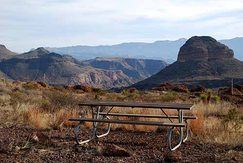 |
|
|
|
[#21]
we did a big loop through West Texas on a Rally last month in the Buick Roadmaster. Took it off some sweet jumps.
|
|
|
|
[#22]
Quoted: It is way less developed than the NP and has way less visitors. There's no stealth camping or anything like that, but you can reserve spots online. It takes hours to get anywhere in the park - just from the main entrance on the highway to the visitors center can take 30-45 min driving on a road that may or may not have been recently graded. BBRSP has some very, very dispersed camping available. Check out the Guale2 spot. I stayed there my first night and it was a bit eerie how far off the grid I was. https://tpwd.texas.gov/state-parks/big-bend-ranch/images/campsites/dsc_0055_500x335.jpg Thanks! After I posted, I did a quick on-line recon of BBRSP. Guale 2 made it to my no. 1 spot for campsites to reserve. It does look like it is the most remote site . . . with a great 360 degree view. My challenge now is getting my hands on it through the reservation system. I may check out Yedra 2 as well. |
|
|
|
[#23]
BBNP has excellent ham radio repeater coverage and is monitored 24/7. The frequencies see a lot of radio traffic as cell phones don't work in most areas.
If you do use a cellphone out there be aware it might ping off Mexican based cell towers and you'll be charged international data rates. |
|
|
|
[#24]
Quoted: If your family includes kids, what are their ages? If they're young, there might be some hiking trails to avoid. If older, sky's the limit. How long are you planning to stay, and is it more offroading or hikiing or some of both? We will be there 4 days. Will be more trail driving than anything else. I’m going to use this trip as shakedown run for my Gladiator build before we go to Moab in the spring. |
|
|
|
[#25]
We were there the end of March. They had just experienced a big fire and many of the trails around Chisos Mountain were closed. They had gas in the park and wifi at Chiso Mountain Lodge and Panther Junction. Most of the park was hard to get a signal on your phone.
We stayed at Chisos Mountain Lodge and it was pretty convenient. They have a store and restaurant that provided takeout meals. BBNP is very remote. We drove from DFW and it was a 1400 mile round trip. I was filling up with gas every time I saw an open gas station. |
|
|
|
[#26]
Quoted: We will be there 4 days. Will be more trail driving than anything else. I’m going to use this trip as shakedown run for my Gladiator build before we go to Moab in the spring. When you get to Moab, do the White Rim in Canyonlands. You can thank me later. |
|
|
|
[#27]
Been twice. As others have said, cell phone signal is spotty. Had Verizon and AT&T. Sway bar fell off 21 miles down a not so beaten path and the shop in town had the bolts needed to repair it. Some of the HIKING trails were not marked for shit. We confirmed this with a park ranger. Stayed at a primitive site near the border, long after dark we were sitting outside the tent drinking wine when a SUV drove down the gravel road, stopped a few hundred yards from us, opened the door shutting it a few moments later. Likely taking a leak but having a long gun with us made us both feel more comfortable. If you can, cross over and bring some $1.00 bills. Have a few drinks and play a round of pool. Good times!
|
|
|
|
[#28]
Quoted: Thanks! After I posted, I did a quick on-line recon of BBRSP. Guale 2 made it to my no. 1 spot for campsites to reserve. It does look like it is the most remote site . . . with a great 360 degree view. My challenge now is getting my hands on it through the reservation system. I may check out Yedra 2 as well. Guale 2 took me 2 hours to get to off the main road. It is remote. Something as simple as a sprained ankle can be tough to deal with. Car trouble even worse. Aint no tow coming to get you. The views are amazing. |
|
|
|
[#29]
 Big Bend National Park 2017 |
|
|
|
[#30]
Quoted: My adult son and I enjoy BBNP in our Jeep Wranglers. We spend all our time on the backcountry roads (camping in what the park calls primitive roadside campsites). We are heading south on the north end of Old Ore Road on one of our first trips with a mostly stock JKUR before employing the air bags that lift the rear end under heavy loads. This JKU was loaded to the roof with gear https://texassailorcom.files.wordpress.com/2018/05/cropped-jkurhr.jpg We try to stay in a different site every night. My favorites include Twisted Shoe on Juniper Canyon Road and Roy’s Peak on Old Ore Road. We love Old Ore Road and always hike the Ernst Tinaja. Mariscal Mine on River Road is also worth investigating. Black Gap Road will be a bit of a disappointment if you are expecting a tough track. Any campsite on River Road (east or west) can be dangerous due to cross river raids. If you cannot lock the jeep (i.e., top is off), then plan on having your shit stolen. Also, keep your edibles in the provided bear boxes. You'll regret it if you don't. We've seen plentiful coyote, bobcat and an occasional mountain lion. Haven't had the pleasure of seeing a Mexican Black Bear yet. Here is my son at Twisted Shoe; camera is pointed NW https://texassailorcom.files.wordpress.com/2021/06/twisted-shoe.jpg We always carry a ton of water; we keep our sidearms on us at all times; we have redundant everything (including fuel in jerry cans). Don’t be lulled into thinking the park is safe and that someone will rescue you if things go south; BBNP isn't an amusement park. Most likely, you will find someone come along to help you. But, relying on it can be deadly. Just for fun, buy and read the book entitled “Death in Big Bend”. You’ll see how easy it is to die there. Temperature swings can be huge. Prepare to dress for snow and oppressive heat all in the same trip. Most likely HEAT; but COLD can also be a problem. Drink more than you think you need. The low humidity will zap you quick . . . even in cooler temps. Try to prepare for breakdowns. My son’s JK transfer case shifter cable slipped off the shifter halfway down Old Ore Road (in one of the rougher sections). As we hadn’t encountered this problem before, it took us a while to analyze and fix the problem. He had shifted the transfer case into neutral at the time the cable separated. We had to manually manipulate the cable after removing the housing because we could not reattach the cable. We needed 4H at the time and used it (never really needed 4L). But, we realized too, that we couldn’t use 4H all the way back to Austin. So, we made sure we could get back into 2H for the road trip back. Since cell service is mostly No Bueno on Old Ore Road (and most of the backcountry), don’t plan on using Google or Youtube to help you solve problems. As long as you prepare and don’t act foolishly, you will have a great time in Big Bend. It is a very beautiful place, and you will want to return often. [EDIT] We do rent Iridium sat phones for the weeks we are in the park. Beats the hell out of purchasing them. I may spend ~$125 for the week + airtime. The peace of mind from the sat phone is worth it. I now have a Garmin InReach nav device as well that allows sat text messages and an SOS beacon. [EDIT 2] Forgot one of the biggest "must haves": a high quality, high duty cycle compressor designed for airing up your tires (like the SmittyBilt] We air down to about 20 psi (or lower) for the backcountry roads. Air back up to 38 psi for the paved roads. Use a good deflator to speed things up on air downs Currie Deflator [EDIT 3] This is overkill for most in terms of navigation, but I use an iOS app called LeadNav (pricey option) along with a GPS dongle so I can totally isolate our nav needs from cell phone coverage. LeadNav offers optional satellite imagery down to a very high resolution; the actual imagery files reside on my iPad (no need for cell service). Also runs on my iPhone. LeadNav is designed for professional offroad racers in remote areas that require good planning to layout routes prior to race day. We can easily see the tracks for both backcountry roads and hiking trails. And, if we need to make our own track in an emergency, we can use the imagery to find a route (offroading is strictly forbidden within the park . . . and for a good reason. It takes decades to repair the damage caused by vehicles) As I mention above, we also have traditional handheld Garmin nav devices, paper trail maps and backcountry road maps, and the Jeep's crappy onboard nav. If we get lost, its because we don't know what we are doing. This is my son's JK on 37s and a 3.5" Metalcloak lift. https://texassailorcom.files.wordpress.com/2019/07/2012-jkr.jpg Coyote on Glenn Springs Road Death in Big Bend is worth a read. |
|
|
|
[#31]
Quoted: It is way less developed than the NP and has way less visitors. There's no stealth camping or anything like that, but you can reserve spots online. It takes hours to get anywhere in the park - just from the main entrance on the highway to the visitors center can take 30-45 min driving on a road that may or may not have been recently graded. BBRSP has some very, very dispersed camping available. Check out the Guale2 spot. I stayed there my first night and it was a bit eerie how far off the grid I was. https://tpwd.texas.gov/state-parks/big-bend-ranch/images/campsites/dsc_0055_500x335.jpg Quoted: Quoted: I have yet to visit BBRSP but it is on my "to do" list. From what I've heard, it is much more undeveloped than the national park. I'm more into overlanding that rock crawling. Does the state park lend itself to covering a bunch of ground each day on the backcountry roads? Are the primitive camping areas more dispersed than centralized? I assume you can't just pick a spot and camp. Is the SP more like the NP in this regard (i.e., primitive backcountry camping)? What do you like about the SP over the NP? What are some of the negatives in regard to the SP? I'd love to hear from the people that frequent the SP. It is way less developed than the NP and has way less visitors. There's no stealth camping or anything like that, but you can reserve spots online. It takes hours to get anywhere in the park - just from the main entrance on the highway to the visitors center can take 30-45 min driving on a road that may or may not have been recently graded. BBRSP has some very, very dispersed camping available. Check out the Guale2 spot. I stayed there my first night and it was a bit eerie how far off the grid I was. https://tpwd.texas.gov/state-parks/big-bend-ranch/images/campsites/dsc_0055_500x335.jpg I enjoyed Chorro Vista at BBSP, great sunrises |
|
|
|
[#32]
Keep in mind if you break down on one of the trails in BBNP, the recovery fee is around $5,000 and will take a couple days. So make sure your vehicle is well equipped and travel with a friend.
|
|
|
|
[#33]
Quoted: Guale 2 took me 2 hours to get to off the main road. It is remote. Something as simple as a sprained ankle can be tough to deal with. Car trouble even worse. Aint no tow coming to get you. The views are amazing. https://www.ar15.com/media/mediaFiles/20133/G2_jpg-1990968.JPG Considering this site for our next trip. How does the path to this campsite compare to any of the roads in the national park? We've never had a problem with any of the roads in the national park. Both vehicles will be Jeep Rubicons. |
|
|
|
[#34]
Quoted: Considering this site for our next trip. How does the path to this campsite compare to any of the roads in the national park? We've never had a problem with any of the roads in the national park. Both vehicles will be Jeep Rubicons. It is an unimproved road. Conditions can vary widely depending upon recent storms and washes. Often it is overgrown with brush, we brought some electric hedge trimmers to avoid pinstriping (one of the vehicles was a rental Dodge Rebel). Any decent 4x4 with ground clearance should be able to negotiate it without damage. |
|
|
|
[#35]
Quoted: It is an unimproved road. Conditions can vary widely depending upon recent storms and washes. Often it is overgrown with brush, we brought some electric hedge trimmers to avoid pinstriping (one of the vehicles was a rental Dodge Rebel). Any decent 4x4 with ground clearance should be able to negotiate it without damage. Unfortunately, pinstriping is unavoidable. I gave up trying to protect my JKU in the first month of ownership . . . it was my first trip to BBNP. We keep a 20V Dewalt reciprocating saw in the tool box. Smaller & lighter than a chainsaw and will run quite awhile on a couple of 6 Ah batteries. I've never used it in a state or national park, though. I assume this is frowned upon. Guale 2 doesn't sound too difficult to reach. We are not averse to stacking rocks. |
|
|
|
[#36]
Guys,
Is there anywhere in the park that allows ATV's on any of the trails? CMOS |
|
|
|
[#37]
Quoted: Guys, Is there anywhere in the park that allows ATV's on any of the trails? CMOS 95% sure that only street legal vehicles are allowed in BBNP. Can't find the rule, but have never seen an ATV or UTV on the roads in all the times we've been there. |
|
|
|
[#38]
Quoted: Guys, Is there anywhere in the park that allows ATV's on any of the trails? CMOS No as stated must be Texas steeet legal. What a kluster ATVs would be https://www.nps.gov/bibe/planyourvisit/atvs.htm |
|
|
|
[#39]
Quoted: No as stated must be Texas steeet legal. What a kluster ATVs would be https://www.nps.gov/bibe/planyourvisit/atvs.htm Can anyone tell me why so many places allow UTV's (SxS) but not ATV's? I don't get it. CMOS |
|
|
|
[#40]
We were there the end of November. I would recommend Ernst tinaja, especially since you plan to do 4x4. We made it there in the f150 but a ton of jeep guys there camping. On the trail in you pass some old graves but other than that the drive in is boring. Until you get to the tinaja. By far the most spectacular views. Trail leading in is foot only but tons of old rusty nic nacs buried about the rocks and sand. If you look hard at the rocks you will find a few with fossilized sealife. The tinaja itself is a hole in the ground that looks like its filled with antifreeze. Its highly toxic because of the mineral content. The rock formation layers are rainbow colored in areas. Great place to camp. Stay armed, bring a metric crapton of water.
Ernst tinaja |
|
|
|
[#41]
Take footwear that is as thornproof as possible. Take water. Plan for cold weather. Don't miss the Window Trail - it's easy. Be careful with valuables.
|
|
|
|
[#42]
Quoted: What would you recommend for a satellite communicator? Garmin inReach is the only answer. Unless you want full voice, in which case rent a satphone. |
|
|
|
[#43]
Quoted: I enjoyed Chorro Vista at BBSP, great sunrises Quoted: Quoted: Quoted: I have yet to visit BBRSP but it is on my "to do" list. From what I've heard, it is much more undeveloped than the national park. I'm more into overlanding that rock crawling. Does the state park lend itself to covering a bunch of ground each day on the backcountry roads? Are the primitive camping areas more dispersed than centralized? I assume you can't just pick a spot and camp. Is the SP more like the NP in this regard (i.e., primitive backcountry camping)? What do you like about the SP over the NP? What are some of the negatives in regard to the SP? I'd love to hear from the people that frequent the SP. It is way less developed than the NP and has way less visitors. There's no stealth camping or anything like that, but you can reserve spots online. It takes hours to get anywhere in the park - just from the main entrance on the highway to the visitors center can take 30-45 min driving on a road that may or may not have been recently graded. BBRSP has some very, very dispersed camping available. Check out the Guale2 spot. I stayed there my first night and it was a bit eerie how far off the grid I was. https://tpwd.texas.gov/state-parks/big-bend-ranch/images/campsites/dsc_0055_500x335.jpg I enjoyed Chorro Vista at BBSP, great sunrises Yes! I stayed at Chorro Vista my second night there. Very cool spot! |
|
|
|
[#44]
Quoted: Guale 2 doesn't sound too difficult to reach. We are not averse to stacking rocks. It's a long drive, like Renegade said, about 2 hours off the main trail. No rock crawling or anything like that - it's just an unimproved road. |
|
|
 Win a FREE Membership!
Sign up for the ARFCOM weekly newsletter and be entered to win a free ARFCOM membership. One new winner* is announced every week!
You will receive an email every Friday morning featuring the latest chatter from the hottest topics, breaking news surrounding legislation, as well as exclusive deals only available to ARFCOM email subscribers.

AR15.COM is the world's largest firearm community and is a gathering place for firearm enthusiasts of all types.
From hunters and military members, to competition shooters and general firearm enthusiasts, we welcome anyone who values and respects the way of the firearm.

Subscribe to our monthly Newsletter to receive firearm news, product discounts from your favorite Industry Partners, and more.
Copyright © 1996-2024 AR15.COM LLC. All Rights Reserved.
Any use of this content without express written consent is prohibited.
AR15.Com reserves the right to overwrite or replace any affiliate, commercial, or monetizable links, posted by users, with our own.