|
[#1]
If you guys on the west coast had plans to evacuate east to beat traffic and everyone who went north instead - be aware the Div. of Emergency Management just told everyone else to do the same.
West coast residents should evacuate to Palm Beach, Broward, Miami-Dade counties, emergency officials say So head out sooner than later - prayers out to everyone, stay safe. |
|
|
|
[#2]
Quoted: Michael in 2018 pretty much moved right to Panama City without much deviation. NHC nailed the track several days out, missed badly on the intensity. |
|
|
|
[#3]
Quoted: We made the decision to leave this morning when we saw that it was cutting up the bay as a Cat 3 and would go over south Tampa. Don’t want to be on the peninsula for that with a 23 month old and a 4 week old. So off to the beach condo in St Aug we go, after I finish getting some things squared away at the house. Wife just said they issued a evac order for zone B which is us. Basically the wealthiest part of town will become a ghost town soon. Odds on my house being more vibrant when we get back? Good choice, just take what’s important/irreplaceable and video/pictures of what’s left. Safe travels |
|
|
|
[#4]
Quoted: If you are in danger of flooding, get your important things (the ones you cant take with you should you evacuate) up as high as you can, filp couches/chairs to stack things on if need be. 2'-3' of water leaves room above it for things to stay dry, 7'-8' not much will be saved in single story home. I hate that this shit is going on for all of you. This and don't forget your garage I had a freezer floating in mine during Irma. Not much you can do about that. But fishing gear, electrical things lawnmowe r anything you don't want wet get it up. Better safe than sorry Eta garage was nasty oily water. |
|
|
|
[#5]
Quoted: The difference between a Sarasota/Venice landfall and a Tarpon Springs landfall is huge for Tampa Bay. Tampa downtown is low and the pump system can only handle so much. NHC track still has eyewall going right up mouth of Tampa Bay |
|
|
|
[#6]
It looks like it's moving east to me...
It going to have to correct more north to hit Tampa. 
|
|
|
|
[#7]
https://www.countryliving.com/food-drinks/a40176/cup-quarter-trick/
Not sure it it is too late for most but if you are planning to leave do this trick to see if you lost power. |
|
|
|
[#8]
Quoted: https://www.countryliving.com/food-drinks/a40176/cup-quarter-trick/ Not sure it it is too late for most but if you are planning to leave do this trick to see if you lost power. You can also just throw a couple ice cubes in a ziploc. Hey, a quarter's a quarter. 
|
|
|
|
[#9]
|
|
|
|
[#10]
 Been though this 20+ times since ‘75 4 red spots are My house (Orlando ) My warehouse (Winter Garden) My machine shop (Brooksville) My anodize shop (St.Pete) Should be fun! |
|
|
|
[#11]
Quoted: NHC nailed the track several days out, missed badly on the intensity. Yes Sir. I remember when my SIL called from Georgia on Friday saying a storm was heading right for PC. I was like well its early and there should be a turn after it gets in the Gulf. Big nope. |
|
|
|
[#12]
11AM update. ~125mph at landfall. Still shifting...and the more it does, likely the higher the intensity will be at landfall |
|
|
|
[#13]
Quoted: NHC track still has eyewall going right up mouth of Tampa Bay Quoted: Quoted: The difference between a Sarasota/Venice landfall and a Tarpon Springs landfall is huge for Tampa Bay. Tampa downtown is low and the pump system can only handle so much. NHC track still has eyewall going right up mouth of Tampa Bay You just do t want it to go to the north of the bay. It'll push a lot more water in there. I've ridden out a cat3 before and it's literally a matter of 50 miles you could have devastation on one end all the way to only have 40mph gusts at the other end. |
|
|
|
[#14]
Track has shifted south per NWS
11AM SUMMARY OF 1100 AM EDT...1500 UTC...INFORMATION----------------------------------------------- LOCATION...23.0N 83.5W ABOUT 305 MI...490 KM SSW OF SARASOTA FLORIDA ABOUT 125 MI...200 KM SSW OF THE DRY TORTUGAS MAXIMUM SUSTAINED WINDS...115 MPH...185 KM/H PRESENT MOVEMENT...N OR 5 DEGREES AT 10 MPH...17 KM/H MINIMUM CENTRAL PRESSURE...963 MB...28.44 INCHES |
|
|
|
[#15]
Quoted: Take a look at the floor in your house and about 10-12" up. Anything below that you may lose to water damage. If you want to keep it move it higher. I was surprised at how much is in that space. We used 4x4s and 2x4s cut to raise furniture we couldn't move at my mother's during a hurricane. Water was rising so fast you could watch it as it climbed the outside wall. This was a Cat1 storm. Good luck to all in the path. This. Good luck to all because on current track it will be bad. |
|
|
|
[#16]
The official track continues to edge East.

|
|
|
|
[#17]
I already know of one death...wife's old boss. Navy guy and a solid person all around from what she says. He was prepping for the storm and had a heart attack.
Ask for help. Go slow, take your time, stay hydrated. Stay safe guys. |
|
|
|
[#18]
Updated storm surge map. Tampa area is now 5-8 ft which is good. South of Tampa has increased to 8-12 ft.
|
|
|
|
[#19]
Quoted: Sorrento, FL checking in... looks like the eye will be super close to the house - literally what the original Euro model showed last Thursday. Looks like ~15in of rain... Dumping the pool right now so it doesn't spill into the house... It's been a good ride. @somaliskinnypirate Also in Sorrento. Thanks for the reminder, need to go drain the pool
|
|
|
|
[#20]
Quoted: Take a look at the floor in your house and about 10-12" up. Anything below that you may lose to water damage. If you want to keep it move it higher. I was surprised at how much is in that space. We used 4x4s and 2x4s cut to raise furniture we couldn't move at my mother's during a hurricane. Water was rising so fast you could watch it as it climbed the outside wall. This was a Cat1 storm. Good luck to all in the path. This is why I bolt my gun safe to the ceiling. |
|
|
|
[#21]
Quoted: I already know of one death...wife's old boss. Navy guy and a solid person all around from what she says. He was prepping for the storm and had a heart attack. Ask for help. Go slow, take your time, stay hydrated. Stay safe guys. Dang. That’s terrible |
|
|
|
[#22]

|
|
|
|
[#23]
it's definitely moving more East now
|
|
|
|
[#24]
Quoted: NHC track still has eyewall going right up mouth of Tampa Bay Cold front moving through Louisiana last night is what is going to make it turn like in the models. |
|
|
|
[#25]
I'm worried about my father in law who won't leave Tarpon Springs. If Ian moves a little more east I guess that's good for everyone north of Tampa but sucks for many others.
I guess we'll wait and see where this goes tomorrow and worry about it then. No sense stressing today too.... |
|
|
|
[#26]
Taken in Cuba sometime this morning.
 Live footage of hurricane Ian that is hits Cuba Now, Then Florida |
|
|
|
[#27]
Quoted: it's definitely moving more East now Broward, Dade and Palm Beach just cancelled school for tomorrow after the 11am update. |
|
|
|
[#28]
Quoted: Cold front moving through Louisiana last night is what is going to make it turn like in the models. Yeah NHC has changed their model tracking more to SE, finally, I think they rely on GFS too much, Euro is more accurate these days. Wobble, wobble, it's real |
|
|
|
[#29]
Keeps shifting east. Looks like it is going to follow Irma's path. I'm predicting a Ft Myers landfall.
|
|
|
|
[#30]
East Central Florida could get hurricane force winds now
|
|
|
|
[#31]
|
|
|
|
[#32]
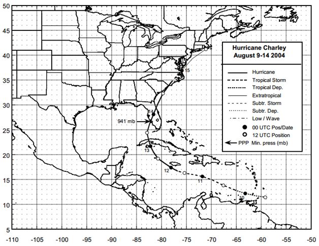
Looks a lot like Charley in 04.
|
|
|
|
[#33]
 Breaking Hurricane Update: Florida |
|
|
|
[#34]
Quoted: Yes Sir. I remember when my SIL called from Georgia on Friday saying a storm was heading right for PC. I was like well its early and there should be a turn after it gets in the Gulf. Big nope. There were about 40 of us laughing about it in a campsite in Holt, making the same comment. Whoops. |
|
|
|
[#35]
Right thru Lakeland, wonderful.
I will be installing shutters tonight. |
|
|
|
[#36]
Quoted: East Central Florida could get hurricane force winds now CAT1 maybe. |
|
|
|
[#37]
Quoted: East Central Florida could get hurricane force winds now Great |
|
|
|
[#38]
Despite all the dire warnings, here in Naples we can see the eye on our radar moving away from Cuba. Currently it is moving in a NNW direction somewhat away from Florida. It hasn't rained more than a sprinkle yet and the winds are calm. My feeling is that it will make landfall further North than currently forecasted. Tampa area is still a likely target.
|
|
|
|
[#39]
This storm is going to fucking suck.
|
|
|
|
[#40]
My boss flew us all to NY
Nice to have a company with a private jet |
|
|
|
[#41]
|
|
|
|
[#42]
Never mind. With the current track we are headed to in-laws in Gainesville.
|
|
|
|
[#43]
Quoted: it's definitely moving more East now just a wobble. last few frames straighten out. |
|
|
|
[#44]
Quoted: Despite all the dire warnings, here in Naples we can see the eye on our radar moving away from Cuba. Currently it is moving in a NNW direction somewhat away from Florida. It hasn't rained more than a sprinkle yet and the winds are calm. My feeling is that it will make landfall further North than currently forecasted. Tampa area is still a likely target. All the weather in the northeast quadrant is currently hitting the east coast and south of Naples. It's coming your way, though. My money is on landfall just north of Cape Coral/Fort Myers. |
|
|
|
[#45]
Quoted: This storm is going to fucking suck. Yes it is. I lost power for 13 days during Irma. This is likely going to do the same. Next couple weeks are gonna blow |
|
|
|
[#46]
|
|
|
|
[#47]
|
|
|
|
[#48]
Quoted: All the weather in the northeast quadrant is currently hitting the east coast and south of Naples. It's coming your way, though. My money is on landfall just north of Cape Coral/Fort Myers. Quoted: Quoted: Despite all the dire warnings, here in Naples we can see the eye on our radar moving away from Cuba. Currently it is moving in a NNW direction somewhat away from Florida. It hasn't rained more than a sprinkle yet and the winds are calm. My feeling is that it will make landfall further North than currently forecasted. Tampa area is still a likely target. All the weather in the northeast quadrant is currently hitting the east coast and south of Naples. It's coming your way, though. My money is on landfall just north of Cape Coral/Fort Myers. That's going to bring some nasty surge to Sanibel. |
|
|
|
[#49]
Not sure how the tides are on the West Coast of Florida today but yesterday I was on the water and the high tide was over most docks. Biggest king tides are in Oct and Nov this year but right now they are abnormally high.
Tampa shows a high tide at 5:30pm Wednesday just before landfall. Marco Island has a high tide at 3:45pm Wednesday. Fingers crossed for low tide at time of landfall. |
|
|
|
[#50]
Quoted: That's going to bring some nasty surge to Sanibel. Coastal towns in between Ft Myers and Sarasota don't exist on any news station. I remember NBC Ft Myers news live after Charley was hitting Captiva, the news folks were like, welp, looks like whatever towns north of us those are F***ed, whatever they are, let's end coverage and go to the phones on Ft Myers beach instead. Sarasota news anything south of square mall may as well be Ft Myers North to them. |
|
|
 Win a FREE Membership!
Sign up for the ARFCOM weekly newsletter and be entered to win a free ARFCOM membership. One new winner* is announced every week!
You will receive an email every Friday morning featuring the latest chatter from the hottest topics, breaking news surrounding legislation, as well as exclusive deals only available to ARFCOM email subscribers.

AR15.COM is the world's largest firearm community and is a gathering place for firearm enthusiasts of all types.
From hunters and military members, to competition shooters and general firearm enthusiasts, we welcome anyone who values and respects the way of the firearm.

Subscribe to our monthly Newsletter to receive firearm news, product discounts from your favorite Industry Partners, and more.
Copyright © 1996-2024 AR15.COM LLC. All Rights Reserved.
Any use of this content without express written consent is prohibited.
AR15.Com reserves the right to overwrite or replace any affiliate, commercial, or monetizable links, posted by users, with our own.