|
Posted: 5/25/2015 12:54:01 PM EDT
FLASH FLOOD WARNING
TXC171-265-251930- /O.NEW.KEWX.FF.W.0078.150525T1632Z-150525T1930Z/ /00000.0.ER.000000T0000Z.000000T0000Z.000000T0000Z.OO/ BULLETIN - EAS ACTIVATION REQUESTED FLASH FLOOD WARNING NATIONAL WEATHER SERVICE AUSTIN/SAN ANTONIO TX 1132 AM CDT MON MAY 25 2015 THE NATIONAL WEATHER SERVICE IN AUSTIN SAN ANTONIO HAS ISSUED A * FLASH FLOOD WARNING FOR... SOUTHWESTERN GILLESPIE COUNTY IN SOUTH CENTRAL TEXAS... KERR COUNTY IN SOUTH CENTRAL TEXAS... * UNTIL 230 PM CDT * AT 1131 AM CDT...DOPPLER RADAR INDICATED A THUNDERSTORM PRODUCING HEAVY RAIN ACROSS THE WARNED AREA. FLASH FLOODING IS EXPECTED TO CONTINUE. * SOME LOCATIONS THAT WILL EXPERIENCE FLOODING INCLUDE... KERRVILLE...HUNT...INGRAM...WALTONIA...KERR WILDLIFE MANAGEMENT AREA...HARPER...MOUNTAIN HOME...CYPRESS CREEK...KERRVILLE STATE PARK...TIVYDALE AND CENTER POINT. ADDITIONAL RAINFALL AMOUNTS OF 1 TO 2 ARE POSSIBLE IN THE WARNED AREA. PRECAUTIONARY/PREPAREDNESS ACTIONS... MOVE TO HIGHER GROUND NOW. ACT QUICKLY TO PROTECT YOUR LIFE. TURN AROUND...DONT DROWN WHEN ENCOUNTERING FLOODED ROADS. MOST FLOOD DEATHS OCCUR IN VEHICLES. FLOODING IS OCCURRING OR IS IMMINENT. IT IS IMPORTANT TO KNOW WHERE YOU ARE RELATIVE TO STREAMS...RIVERS...OR CREEKS WHICH CAN BECOME KILLERS IN HEAVY RAINS. CAMPERS AND HIKERS SHOULD AVOID STREAMS OR CREEKS. && LAT...LON 2992 9895 2992 9957 3023 9962 3029 9939 3029 9930 3031 9930 3040 9897 $$ MSL If you're west of Austin, be safe. Your area and the DFW area is under another tornado watch. Y'all be safe! 
|
|
|
|
[#1]
Checked the radar a few minutes ago - nice bow echo ongoing in the western half of the state. Derecho Days are here again, from the looks of things.
Stay safe. |
|
|
|
[#2]
I am on my way to Big Lake. Driving right through Kerrville.

|
|
|
|
[#3]
Quoted: I am on my way to Big Lake. Driving right through Kerrville. Be safe! It's cleared up here in Midland. 
|
|
|
|
[#4]
my 150gpm pump has had lots and lots of gas through it this year trying to keep my yard from becoming a pond
my first attempt at a garden is under there, somewhere 
|
|
|
|
[#5]
Load mags like a mofo
|
|
|
|
[#6]
Damn...
Keep aware today. |
|
|
|
[#7]
|
|
|
|
[#8]
I'm in Houston county and I'm sick of this shit. Expecting ~3 more inches this afternoon. We've already had 57" since October. That's 20" over our annual average. My pastures are so saturated that pecan trees are falling over just because the roots can't hold them up anymore.
And the pine trees in the nat'l forest are falling for the same reason. Already had to replace over 1/2 mile of fence from tree damage. Probably more damage out there, but I don't have anything that can get to some parts of the ranch. Mud is too deep even for horses to cross. I knew I should have bought an LCAC. On the plus side, I'm guessing there won't be much risk of forest fires this year... |
|
|
|
[#9]
Yow. As if they haven't had enough...
|
|
|
|
[#10]
Abilene here. Just had a major rainstorm come across here
|
|
|
|
[#11]
Yes, the thunder is pretty much continous at this point. No heavy rain yet.
|
|
|
|
[#12]
Just missing us here in Leander, so far.
|
|
|
|
[#13]
|
|
|
|
[#14]
This doesn't imbed properly...good aerial video of Wimberley flooding..pretty much took out downtown..
https://www.youtube.com/watch?t=15&v=ZmKcA7s9mZI |
|
|
|
[#15]
A tornado does not make a pimple on a wall of waters ass. |
|
|
|
[#16]
I'm frantically putting dry dirt into an envelope to send to you guys!
In all seriousness though man, you guys have had a LOT of water. |
|
|
|
[#17]
Young County now Tornado Warned.
|
|
|
|
[#18]
Quoted:
I'm frantically putting dry dirt into an envelope to send to you guys! In all seriousness though man, you guys have had a LOT of water. Want some of our water? |
|
|
|
[#19]
Great- got held by a flash flood last wk going to Austin and probably will be again tomorrow.
Posted Via AR15.Com Mobile |
|
|
|
[#20]
Stay safe you TX guys !
|
|
|
|
[#21]
Quoted:
Want some of our water? Quoted:
Quoted:
I'm frantically putting dry dirt into an envelope to send to you guys! In all seriousness though man, you guys have had a LOT of water. Want some of our water? And some of Colorados too if we could! Its so damn dry here...... |
|
|
|
[#22]
Quoted:
Young County now Tornado Warned. Ugh...my mother lives in Young county. Tried to call, but lines are busy. |
|
|
|
[#23]
Quoted:
my 150gpm pump has had lots and lots of gas through it this year trying to keep my yard from becoming a pond my first attempt at a garden is under there, somewhere Might want to change up the garden to a rice paddy.... |
|
|
|
[#24]
There are still two families missing from the Blanco flood. Friends of friends. They two families got together and rented a house for the weekend. House was washed off the stilts and floated down the river until it hit the bridge and shattered. The father of one of the families is the body mentioned in the article. Everyone else is still missing. |
|
|
|
[#25]
We've gotten the log jams cleaned out so maybe that will help with any possible flooding.
 County added the cone for safety.  |
|
|
|
[#26]
Damn, Texans are never happy. They were just bitching about the drought and now they're bitching about the rain.
 Stay safe guys. |
|
|
|
[#27]
Fredricksberg area now tornado warned.
TORNADO WARNING FOR... NORTHERN BLANCO COUNTY IN SOUTH CENTRAL TEXAS... EAST CENTRAL GILLESPIE COUNTY IN SOUTH CENTRAL TEXAS... * UNTIL 115 PM CDT * AT 1251 PM CDT...A SEVERE THUNDERSTORM CAPABLE OF PRODUCING A TORNADO WAS LOCATED NEAR HYE...OR 16 MILES EAST OF FREDERICKSBURG...MOVING NORTHEAST AT 35 MPH. HAZARD...TORNADO AND QUARTER SIZE HAIL. SOURCE...RADAR INDICATED ROTATION. IMPACT...FLYING DEBRIS WILL BE DANGEROUS TO THOSE CAUGHT WITHOUT SHELTER. MOBILE HOMES WILL BE DAMAGED OR DESTROYED. DAMAGE TO ROOFS...WINDOWS AND VEHICLES WILL OCCUR. TREE DAMAGE IS LIKELY. * THIS DANGEROUS STORM WILL BE NEAR... ROCKY CREEK AROUND 1255 PM CDT. SANDY AROUND 105 PM CDT. JOHNSON CITY AROUND 110 PM CDT. ROUND MOUNTAIN AND CYPRESS MILL AROUND 115 PM CDT. |
|
|
|
[#28]
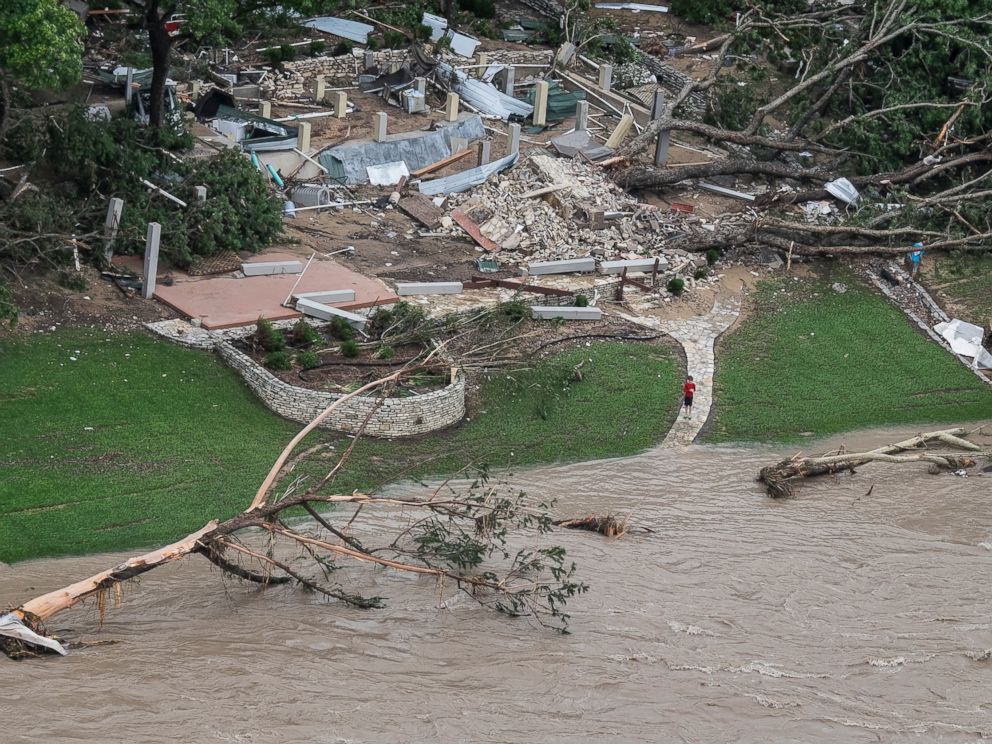
Is this a 10 year flood or something unprecedented? Asking because lots of the stuff being flooded looks like relatively new construction.
|
|
|
|
[#29]
Quoted: Is this a 10 year flood or something unprecedented? Asking because lots of the stuff being flooded looks like relatively new construction. Record flood. The river rose over 20 feet in an hour yesterday...basically in a valley so it was confined to a chute. |
|
|
|
[#30]
Quoted:
Is this a 10 year flood or something unprecedented? Asking because lots of the stuff being flooded looks like relatively new construction. most construction is designed around a 50-100 year storm event. This is based off a number at the time of construction, so new development would increase flood potential of existing developments. |
|
|
|
[#31]
Quoted: Record flood. The river rose over 20 feet in an hour yesterday...basically in a valley so it was confined to a chute. Quoted: Quoted: Is this a 10 year flood or something unprecedented? Asking because lots of the stuff being flooded looks like relatively new construction. Record flood. The river rose over 20 feet in an hour yesterday...basically in a valley so it was confined to a chute. |
|
|
|
[#32]
Abilene got it. Heavy rain
|
|
|
|
[#33]
Trinity River at 4th Street, Fort Worth, yesterday:
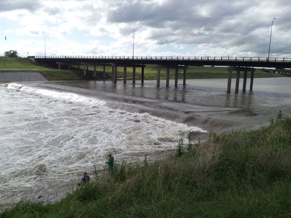
The standing wave is pretty nifty. This shows the height of the water. 
|
|
|
|
[#34]
Quoted: So no flood coverage for the majority involved. Damn. Quoted: Quoted: Quoted: Is this a 10 year flood or something unprecedented? Asking because lots of the stuff being flooded looks like relatively new construction. Record flood. The river rose over 20 feet in an hour yesterday...basically in a valley so it was confined to a chute. After several years of drought in Texas...it's amazing anybody has flood insurance. |
|
|
|
[#35]
Quoted:
Checked the radar a few minutes ago - nice bow echo ongoing in the western half of the state. Derecho Days are here again, from the looks of things. Stay safe. Look at it now. http://radar.weather.gov/radar.php?rid=fws&product=N0R&overlay=11101111&loop=no |
|
|
|
[#36]
Quoted:
Is this a 10 year flood or something unprecedented? Asking because lots of the stuff being flooded looks like relatively new construction. The crest on the Blanco a few days ago in Wimberly was the highest ever recorded. Previous surge was 33 feet in 1929 (I think). Two days ago it hit over 40 feet. |
|
|
|
[#37]
TORNADO WARNING
TXC053-251845- /O.NEW.KEWX.TO.W.0023.150525T1808Z-150525T1845Z/ BULLETIN - EAS ACTIVATION REQUESTED TORNADO WARNING NATIONAL WEATHER SERVICE AUSTIN/SAN ANTONIO TX 108 PM CDT MON MAY 25 2015 THE NATIONAL WEATHER SERVICE IN AUSTIN SAN ANTONIO HAS ISSUED A * TORNADO WARNING FOR... NORTHWESTERN BURNET COUNTY IN SOUTH CENTRAL TEXAS... * UNTIL 145 PM CDT * AT 108 PM CDT...A SEVERE THUNDERSTORM CAPABLE OF PRODUCING A TORNADO WAS LOCATED 7 MILES WEST OF LAKE VICTOR...OR 11 MILES NORTHEAST OF BUCHANAN DAM...MOVING NORTH AT 40 MPH. HAZARD...TORNADO AND QUARTER SIZE HAIL. SOURCE...RADAR INDICATED ROTATION. IMPACT...FLYING DEBRIS WILL BE DANGEROUS TO THOSE CAUGHT WITHOUT SHELTER. MOBILE HOMES WILL BE DAMAGED OR DESTROYED. DAMAGE TO ROOFS...WINDOWS AND VEHICLES WILL OCCUR. TREE DAMAGE IS LIKELY. * THIS TORNADIC THUNDERSTORM WILL REMAIN OVER MAINLY RURAL AREAS OF NORTHWESTERN BURNET COUNTY. |
|
|
|
[#38]
Quoted: The crest on the Blanco a few days ago in Wimberly was the highest ever recorded. Previous surge was 33 feet in 1929 (I think). Two days ago it hit over 40 feet. Quoted: Quoted: Is this a 10 year flood or something unprecedented? Asking because lots of the stuff being flooded looks like relatively new construction. The crest on the Blanco a few days ago in Wimberly was the highest ever recorded. Previous surge was 33 feet in 1929 (I think). Two days ago it hit over 40 feet. |
|
|
|
[#39]
Quoted: Look at it now. http://radar.weather.gov/radar.php?rid=fws&product=N0R&overlay=11101111&loop=no Quoted: Quoted: Checked the radar a few minutes ago - nice bow echo ongoing in the western half of the state. Derecho Days are here again, from the looks of things. Stay safe. Look at it now. http://radar.weather.gov/radar.php?rid=fws&product=N0R&overlay=11101111&loop=no ...and it's all converging on DFW. Y'all stay safe! |
|
|
|
[#40]
Stay safe texans
Stay frosty also
|
|
|
|
[#41]
Confirmed tornado near Round Mountain and Hwy 281 per T.V.
|
|
|
|
[#42]
Quoted:
I'm ignorant on the subject, but one of my favorite places in Texas is the San Antonio riverwalk. Is that about to be or already all jacked up? Quoted:
Quoted:
Quoted:
Is this a 10 year flood or something unprecedented? Asking because lots of the stuff being flooded looks like relatively new construction. The crest on the Blanco a few days ago in Wimberly was the highest ever recorded. Previous surge was 33 feet in 1929 (I think). Two days ago it hit over 40 feet. Honestly, San Antonio is a bit south of what I'm familiar with. Did see this picture posted by a friend the other day of the river walk: 
|
|
|
|
[#43]
NWS reported (via wundermap) tornado near Fredricksburg at 13:45 today;
system heading east towards Austin the riverwalk in SA has flooded in the past, but has FLOOD gates that can lower the level if the guy ain't drunk,,,,,,
|
|
|
|
[#44]
Been getting sporty for sure.
|
|
|
|
[#45]
Quoted:
my 150gpm pump has had lots and lots of gas through it this year trying to keep my yard from becoming a pond my first attempt at a garden is under there, somewhere <a href="http://s1054.photobucket.com/user/texrdnec/media/DB3A0756-1E76-4544-B3CF-05456C806839_zpshbpxhhxz.jpg.html" target="_blank">http://i1054.photobucket.com/albums/s482/texrdnec/DB3A0756-1E76-4544-B3CF-05456C806839_zpshbpxhhxz.jpg</a> Trying rice this year? |
|
|
|
[#46]
BURNET TX-
115 PM CDT MON MAY 25 2015 ...A TORNADO WARNING REMAINS IN EFFECT UNTIL 145 PM CDT FOR NORTHWESTERN BURNET COUNTY... AT 115 PM CDT...A SEVERE THUNDERSTORM CAPABLE OF PRODUCING A TORNADO WAS LOCATED NEAR LAKE VICTOR...OR 8 MILES SOUTHWEST OF LAMPASAS... MOVING NORTH AT 35 MPH. HAZARD...TORNADO AND QUARTER SIZE HAIL. SOURCE...RADAR INDICATED ROTATION. IMPACT...FLYING DEBRIS WILL BE DANGEROUS TO THOSE CAUGHT WITHOUT SHELTER. MOBILE HOMES WILL BE DAMAGED OR DESTROYED. DAMAGE TO ROOFS...WINDOWS AND VEHICLES WILL OCCUR. TREE DAMAGE IS LIKELY. THIS TORNADIC THUNDERSTORM WILL REMAIN OVER MAINLY RURAL AREAS OF NORTHWESTERN BURNET COUNTY. PRECAUTIONARY/PREPAREDNESS ACTIONS... TAKE COVER NOW! MOVE TO A BASEMENT OR AN INTERIOR ROOM ON THE LOWEST FLOOR OF A STURDY BUILDING. AVOID WINDOWS. IF YOU ARE OUTDOORS...IN A MOBILE HOME...OR IN A VEHICLE...MOVE TO THE CLOSEST SUBSTANTIAL SHELTER AND PROTECT YOURSELF FROM FLYING DEBRIS. && LAT...LON 3087 9821 3092 9840 3103 9837 3103 9815 TIME...MOT...LOC 1815Z 197DEG 32KT 3097 9828 TORNADO...RADAR INDICATED HAIL...1.00IN $$ |
|
|
|
[#47]
774 WFUS54 KFWD 251824 TORFWD TXC281-251900- /O.NEW.KFWD.TO.W.0089.150525T1824Z-150525T1900Z/ BULLETIN - EAS ACTIVATION REQUESTED TORNADO WARNING NATIONAL WEATHER SERVICE FORT WORTH TX 124 PM CDT MON MAY 25 2015 THE NATIONAL WEATHER SERVICE IN FORT WORTH HAS ISSUED A * TORNADO WARNING FOR... EASTERN LAMPASAS COUNTY IN CENTRAL TEXAS... * UNTIL 200 PM CDT * AT 123 PM CDT...A SEVERE THUNDERSTORM CAPABLE OF PRODUCING A TORNADO WAS LOCATED 8 MILES SOUTH OF LAMPASAS...MOVING NORTH AT 30 MPH. HAZARD...TORNADO. SOURCE...RADAR INDICATED ROTATION. IMPACT...FLYING DEBRIS WILL BE DANGEROUS TO THOSE CAUGHT WITHOUT SHELTER. MOBILE HOMES WILL BE DAMAGED OR DESTROYED. DAMAGE TO ROOFS...WINDOWS AND VEHICLES WILL OCCUR. TREE DAMAGE IS LIKELY. * THIS DANGEROUS STORM WILL BE NEAR... LAMPASAS AROUND 135 PM CDT. PRECAUTIONARY/PREPAREDNESS ACTIONS... TAKE COVER NOW! MOVE TO AN INTERIOR ROOM ON THE LOWEST FLOOR OF A STURDY BUILDING. AVOID WINDOWS. IF YOU ARE OUTDOORS...IN A MOBILE HOME...OR IN A VEHICLE...MOVE TO THE CLOSEST SUBSTANTIAL SHELTER AND PROTECT YOURSELF FROM FLYING DEBRIS. && LAT...LON 3134 9824 3138 9812 3112 9795 3103 9803 3103 9832 3104 9832 TIME...MOT...LOC 1823Z 200DEG 26KT 3101 9821 TORNADO...RADAR INDICATED HAIL...<.75IN $$ 92 |
|
|
|
[#48]
980 WWUS54 KEWX 251824 SVSEWX SEVERE WEATHER STATEMENT NATIONAL WEATHER SERVICE AUSTIN/SAN ANTONIO TX 124 PM CDT MON MAY 25 2015 TXC031-053-299-251900- /O.CON.KEWX.TO.W.0024.000000T0000Z-150525T1900Z/ LLANO TX-BURNET TX-BLANCO TX- 124 PM CDT MON MAY 25 2015 ...A TORNADO WARNING REMAINS IN EFFECT UNTIL 200 PM CDT FOR SOUTHEASTERN LLANO...SOUTHWESTERN BURNET AND NORTH CENTRAL BLANCO COUNTIES... AT 123 PM CDT...A CONFIRMED LARGE AND EXTREMELY DANGEROUS TORNADO WAS LOCATED NEAR ROUND MOUNTAIN...MOVING NORTHEAST AT 35 MPH. THIS IS A PARTICULARLY DANGEROUS SITUATION. HAZARD...DAMAGING TORNADO. SOURCE...LAW ENFORCEMENT CONFIRMED TORNADO NEAR ROUND MOUNTAIN. IMPACT...YOU ARE IN A LIFE THREATENING SITUATION. FLYING DEBRIS MAY BE DEADLY TO THOSE CAUGHT WITHOUT SHELTER. MOBILE HOMES WILL BE DESTROYED. CONSIDERABLE DAMAGE TO HOMES...BUSINESSES AND VEHICLES IS LIKELY AND COMPLETE DESTRUCTION IS POSSIBLE. THE TORNADO WILL BE NEAR... GRANITE SHOALS AND HIGHLAND HAVEN AROUND 135 PM CDT. MEADOWLAKES AROUND 140 PM CDT. MARBLE FALLS AND SMITHWICK AROUND 145 PM CDT. OTHER LOCATIONS IMPACTED BY THIS TORNADIC THUNDERSTORM INCLUDE COTTONWOOD SHORES AND SUNRISE BEACH VILLAGE. PRECAUTIONARY/PREPAREDNESS ACTIONS... TO REPEAT...A LARGE...EXTREMELY DANGEROUS AND POTENTIALLY DEADLY TORNADO IS ON THE GROUND. TO PROTECT YOUR LIFE...TAKE COVER NOW! MOVE TO A BASEMENT OR AN INTERIOR ROOM ON THE LOWEST FLOOR OF A STURDY BUILDING. AVOID WINDOWS. IF YOU ARE OUTDOORS...IN A MOBILE HOME...OR IN A VEHICLE...MOVE TO THE CLOSEST SUBSTANTIAL SHELTER AND PROTECT YOURSELF FROM FLYING DEBRIS. && LAT...LON 3036 9835 3048 9850 3055 9844 3067 9833 3062 9810 3057 9808 3057 9809 TIME...MOT...LOC 1823Z 223DEG 31KT 3048 9837 TORNADO...OBSERVED TORNADO DAMAGE THREAT...CONSIDERABLE HAIL...1.75IN $$ |
|
|
|
[#49]
I guess river camp, El Rancho Cima is gone turkey just in time for summer camp.
|
|
|
|
[#50]
Quoted: Honestly, San Antonio is a bit south of what I'm familiar with. Did see this picture posted by a friend the other day of the river walk: http://i61.tinypic.com/f3hy1h.jpg Quoted: Quoted: I'm ignorant on the subject, but one of my favorite places in Texas is the San Antonio riverwalk. Is that about to be or already all jacked up? Honestly, San Antonio is a bit south of what I'm familiar with. Did see this picture posted by a friend the other day of the river walk: http://i61.tinypic.com/f3hy1h.jpg |
|
|
 Win a FREE Membership!
Sign up for the ARFCOM weekly newsletter and be entered to win a free ARFCOM membership. One new winner* is announced every week!
You will receive an email every Friday morning featuring the latest chatter from the hottest topics, breaking news surrounding legislation, as well as exclusive deals only available to ARFCOM email subscribers.

AR15.COM is the world's largest firearm community and is a gathering place for firearm enthusiasts of all types.
From hunters and military members, to competition shooters and general firearm enthusiasts, we welcome anyone who values and respects the way of the firearm.

Subscribe to our monthly Newsletter to receive firearm news, product discounts from your favorite Industry Partners, and more.
Copyright © 1996-2024 AR15.COM LLC. All Rights Reserved.
Any use of this content without express written consent is prohibited.
AR15.Com reserves the right to overwrite or replace any affiliate, commercial, or monetizable links, posted by users, with our own.