|
[#1]
Quoted:
I believe that those tubes take air from inside the car and are routed to the air intake of the police car to limit intake of ash into the engine. That pic is from the last big eruption of Mt. St. Helens I would think the cabin filter would clog up pretty quick by doing this.. Quoted:
Quoted:
Quoted:
... What are we looking at exactly? I believe that those tubes take air from inside the car and are routed to the air intake of the police car to limit intake of ash into the engine. That pic is from the last big eruption of Mt. St. Helens I would think the cabin filter would clog up pretty quick by doing this.. Cabin air filters didn't exist except in luxury cars until the late 90's. Those hoses were to slow the air down enough to let the ash fall to the floor on the trip through. If you've looked at ash under a microscope, they are like little razor sharp arrowheads/snowflakes/all sorts of shapes, which slice open lungs when breathed, and really screw up an engine when ingested. Most all the ash from the eruption 30 years ago has improved the soil to the East of Mt. St. Helens by becoming incorporated with it, allowing water to flow and prevent compaction. There were massive shipments of ash scraped off the streets sent here and other parts of the midwest for farmers to till into their soil to prevent clumping. |
|
|
|
[#2]
And not a single fuck was given that day.

|
|
|
|
[#3]
That's a cool picture |
|
|
|
[#4]
... Fascinating thread!
|
|
|
|
[#5]
Like a fucking boss. |
|
|
|
[#6]
Another amazing set of pictures considering the story...
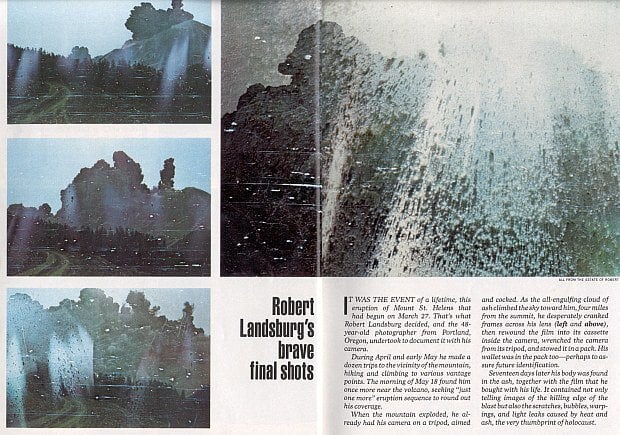 Photographer Robert Landsburg was 7 miles away when it blew. Realizing he could not outrun it, he stuffed the film in his backpack and covered it with his body, which was found 17 days later. http://petapixel.com/2011/09/07/photographer-died-protecting-his-film-during-the-1980-mt-st-helens-eruption/ |
|
|
|
[#7]
I'm not concerned about St.helens.
If Rainer erupts though, I hope it happens during the day. I'll grab a six pack and watch |
|
|
|
[#8]
Mt. Saint Helens rebuilding itself. Subduction zones and volcanic activity. Volcanoes in the Cascades could suddenly erupt without warning probably, like Ontake did. 9/10/14, 52 earthquakes at Ontake. 9/11/14, 80 something earthquakes, and after that it dissipated to 0~daily average, on top of not showing any deformation or gas release.
The ETS event for the CSZ is coming up, but there might have been 3 recently according to a post on the PNSN. more is here PNSN Tremor research and Current Events/Maps. |
|
|
|
[#9]
Quoted:
I remember when she blew her top in 1980. Dark billowing clouds rolled in. Our street lights came on from 200 miles away. I thought the Russians just nuked us. You mean the months of earthquakes beforehand and incessant news coverage weren't clues enough for you that it wasn't the damn Rooskies? 
|
|
|
|
[#10]
Quoted:
Is that the lookout on #30 with the Longview Bridge in the background ? Used to ride that route to go motorcycle camping at Ft Stevens. Quoted:
Quoted:
I look at the mountain every day from my front porch (about 40 miles from my place). It's easy to tell when it's doing something from the many cars parked along side of the highway with folks pointing their camera phones that way. http://i179.photobucket.com/albums/w303/theoneandonlyhoppy/mount_st_helens_from_mayger_oregon_2005_zpsb3a2a5ab.jpg http://i179.photobucket.com/albums/w303/theoneandonlyhoppy/securedownload.jpg A good friend was a kid the last time it erupted. Him and a buddy made good money cleaning out ash from peoples gutters before they fell off the house. Right up until they were told to stop because they didn't have a permit. 
Is that the lookout on #30 with the Longview Bridge in the background ? Used to ride that route to go motorcycle camping at Ft Stevens. That's what it looks like. |
|
|
|
[#11]
Quoted:
Spirit Lake still looks like Oatmeal! It's going to be awesome. As far as Rainier... Meh. Meh I say. I live on a hill. If the massive mudslides even get to me, what am I going to do? Just weather it I guess... I live too close to the Nisqually. I may move when my lease is up after looking at lahar hazard zones. I know its a small chance... but my neighborhood is rough too. |
|
|
|
[#12]
Quoted:
Is that the lookout on #30 with the Longview Bridge in the background ? Used to ride that route to go motorcycle camping at Ft Stevens. Quoted:
Quoted:
I look at the mountain every day from my front porch (about 40 miles from my place). It's easy to tell when it's doing something from the many cars parked along side of the highway with folks pointing their camera phones that way. http://i179.photobucket.com/albums/w303/theoneandonlyhoppy/mount_st_helens_from_mayger_oregon_2005_zpsb3a2a5ab.jpg http://i179.photobucket.com/albums/w303/theoneandonlyhoppy/securedownload.jpg A good friend was a kid the last time it erupted. Him and a buddy made good money cleaning out ash from peoples gutters before they fell off the house. Right up until they were told to stop because they didn't have a permit.
Is that the lookout on #30 with the Longview Bridge in the background ? Used to ride that route to go motorcycle camping at Ft Stevens. Exactly. Same place, different ride (about ten minutes before I totaled it). 
|
|
|
|
[#13]
Quick, someone throw in a sacrifice.
|
|
|
|
[#14]
Quoted:
I will admit my ignorance on why Rainier is dangerous. So why are folks in WA more afraid of Rainier than Helens? Rainier, 70 miles to Seattul Mt. St. Helens, 50 miles to Portlund Maybe there's some derp here, or maybe there are natural watercourses coming off of Rainier that are likely to conduct the massive mudflows that are expected. Either way... it's gonna be an un-fun time when this SHTF. |
|
|
|
[#15]
Meh, I'm on the west side of the sound, I'll make some popcorn and watch the show.
My dad told me about the 1980 eruption, he was in Port Angeles, like 150 miles away, and thought the commies had just nuked us when it blew. |
|
|
|
[#16]
Quoted:
You mean the months of earthquakes beforehand and incessant news coverage weren't clues enough for you that it wasn't the damn Rooskies? Quoted:
Quoted:
I remember when she blew her top in 1980. Dark billowing clouds rolled in. Our street lights came on from 200 miles away. I thought the Russians just nuked us. You mean the months of earthquakes beforehand and incessant news coverage weren't clues enough for you that it wasn't the damn Rooskies? I was 11 years old, living on the east side. Was up on roof helping my dad do some patch work. Came down and turned on the radio. |
|
|
|
[#17]
Quoted:
Rainier, 70 miles to Seattul Mt. St. Helens, 50 miles to Portlund Maybe there's some derp here, or maybe there are natural watercourses coming off of Rainier that are likely to conduct the massive mudflows that are expected. Either way... it's gonna be an un-fun time when this SHTF. Quoted:
Quoted:
I will admit my ignorance on why Rainier is dangerous. So why are folks in WA more afraid of Rainier than Helens? Rainier, 70 miles to Seattul Mt. St. Helens, 50 miles to Portlund Maybe there's some derp here, or maybe there are natural watercourses coming off of Rainier that are likely to conduct the massive mudflows that are expected. Either way... it's gonna be an un-fun time when this SHTF. St. Helens poses no major threat to Portland and even then it's highly dependent on the wind, Rainer is expected to wipe out the whole Puyallup river basin if it goes. |
|
|
|
[#18]
I saw a lot of the flow from St. Helens live. Scary shit.
|
|
|
|
[#19]
Quoted:
Rainier, 70 miles to Seattul Mt. St. Helens, 50 miles to Portlund Maybe there's some derp here, or maybe there are natural watercourses coming off of Rainier that are likely to conduct the massive mudflows that are expected. Either way... it's gonna be an un-fun time when this SHTF. Quoted:
Quoted:
I will admit my ignorance on why Rainier is dangerous. So why are folks in WA more afraid of Rainier than Helens? Rainier, 70 miles to Seattul Mt. St. Helens, 50 miles to Portlund Maybe there's some derp here, or maybe there are natural watercourses coming off of Rainier that are likely to conduct the massive mudflows that are expected. Either way... it's gonna be an un-fun time when this SHTF. Yeah, there's a lot of derp there. South Seattle is built on mudflow from Rainier, as is the Tacoma tideflats and the Port of Tacoma. Look up hwy 167 on google maps. That entire valley is mudflow. Follow the rivers up to Rainier, the White, Puyallup, Carbon, they all flow into heavily populated areas. The Nisqually delta gets wiped out and it will cut off all access from the south into the area. Only way into Seattle would be over the mountains on I-90. If it were to happen during the winter the mountain passes north of there would be closed for the winter. St Helens has never effected the Portland region. The Toutle River dumps into the Cowlitz which in turn dumps into the Columbia at which point it's downstream from Portland. |
|
|
|
[#20]
Quoted:
Rainier, 70 miles to Seattul Mt. St. Helens, 50 miles to Portlund Maybe there's some derp here, or maybe there are natural watercourses coming off of Rainier that are likely to conduct the massive mudflows that are expected. Either way... it's gonna be an un-fun time when this SHTF. Quoted:
Quoted:
I will admit my ignorance on why Rainier is dangerous. So why are folks in WA more afraid of Rainier than Helens? Rainier, 70 miles to Seattul Mt. St. Helens, 50 miles to Portlund Maybe there's some derp here, or maybe there are natural watercourses coming off of Rainier that are likely to conduct the massive mudflows that are expected. Either way... it's gonna be an un-fun time when this SHTF. In the Enumclaw area there's mud deposits 40 feet deep from the last time there was a lahar http://volcanoes.usgs.gov/volcanoes/mount_rainier/mount_rainier_hazard_50.html |
|
|
|
[#21]
I was at Northwest Trek animal park when Helens blew. Day after my birthday....I just remember the family pilling everyone in the car and heading back to Federal Way. We had ash up there a day later, not much but I still remember that cloud...I will never forget that. The ground shaking and the noise.
Helens will be a fire cracker compared to Rainier if it ever goes. If Rainier decides to pop, we are talking MASSIVE destruction for western Wa. |
|
|
|
[#22]
Quoted:
You mean the months of earthquakes beforehand and incessant news coverage weren't clues enough for you that it wasn't the damn Rooskies? Quoted:
Quoted:
I remember when she blew her top in 1980. Dark billowing clouds rolled in. Our street lights came on from 200 miles away. I thought the Russians just nuked us. You mean the months of earthquakes beforehand and incessant news coverage weren't clues enough for you that it wasn't the damn Rooskies? Maybe you are not old enough to remember the pre-internet era or a world without cell phones and where cable TV was uncommon and most people received their news from local sources. News didn't travel as fast back then and it wasn't nearly as easy or common to follow distant happenings as it is now. Sure, people in the Seattle to Portland corridor were probably innundated with coverage. Outside of that area, not as much. As a 12 year old kid living in Spokane at the time, Seattle, Portland and Mt St Helens might as well have been half way around the world. I vaguely remember the mountain being briefly reported on in the local Spokane news. It seemed like just another far off location. Most people in the area didn't really know what was going on that Sunday afternoon when the skies suddenly darkened early in the afternoon and grey stuff started falling out of the air. |
|
|
|
[#23]
Quoted:
I was at Northwest Trek animal park when Helens blew. Day after my birthday....I just remember the family pilling everyone in the car and heading back to Federal Way. We had ash up there a day later, not much but I still remember that cloud...I will never forget that. The ground shaking and the noise. How did the animals react? |
|
|
|
[#24]
Quoted:
Maybe you are not old enough to remember the pre-internet era or a world where cable TV was uncommon and most people received their news from local sources. News didn't travel as fast back then and it wasn't nearly as easy or common to follow distant happenings as it is now. Sure, people in the Seattle to Portland corridor were probably innundated with coverage. Outside of that area, not as much. As a 12 year old kid living in Spokane at the time, Seattle, Portland and Mt St Helens might as well have been half way around the world. I vaguely remember the mountain being briefly reported on in the local Spokane news. It seemed like just another far off location. Most people in the area didn't really know what was going on that Sunday afternoon when the skies suddenly darkened early in the afternoon and grey stuff started falling out of the air. Quoted:
Quoted:
Quoted:
I remember when she blew her top in 1980. Dark billowing clouds rolled in. Our street lights came on from 200 miles away. I thought the Russians just nuked us. You mean the months of earthquakes beforehand and incessant news coverage weren't clues enough for you that it wasn't the damn Rooskies? Maybe you are not old enough to remember the pre-internet era or a world where cable TV was uncommon and most people received their news from local sources. News didn't travel as fast back then and it wasn't nearly as easy or common to follow distant happenings as it is now. Sure, people in the Seattle to Portland corridor were probably innundated with coverage. Outside of that area, not as much. As a 12 year old kid living in Spokane at the time, Seattle, Portland and Mt St Helens might as well have been half way around the world. I vaguely remember the mountain being briefly reported on in the local Spokane news. It seemed like just another far off location. Most people in the area didn't really know what was going on that Sunday afternoon when the skies suddenly darkened early in the afternoon and grey stuff started falling out of the air. We were lucky here in SE King County. All the ash blew east but I remember seeing on the news it turning pitch black in Yakima in the middle of the day. We did end up getting ash but it was about a week later the winds finally blew it around to us. Just a light dusting. Still cracks me up on the anniversary of the eruption all these people in Tacoma and Seattle talking about the ash they got that day. I think their memories are off a bit. |
|
|
|
[#25]
Quoted:
I guess this is the new lava dome: http://news.nationalgeographic.com/u/TvyamNb-BivtNwpvn7Sct0VFDulyAfA9wBcU0gVHVnqC5ghsgreCgRpju2zLiFWBeA6_t25x5l_nC1VuLXk/ Say Hello......To my little friend! |
|
|
|
[#26]
Quoted: Mt. Saint Helens rebuilding itself. Subduction zones and volcanic activity. Volcanoes in the Cascades could suddenly erupt without warning probably, like Ontake did. 9/10/14, 52 earthquakes at Ontake. 9/11/14, 80 something earthquakes, and after that it dissipated to 0~daily average, on top of not showing any deformation or gas release. The ETS event for the CSZ is coming up, but there might have been 3 recently according to a post on the PNSN. more is here PNSN Tremor research and Current Events/Maps. Oh man. I had not heard about Ontake. Nothing on the new about it. |
|
|
|
[#27]
Quoted:
Mt. Saint Helens, before and after pix: http://brianabbott.net/media/photos/travels/1994/POSTCRD1.jpg https://encrypted-tbn0.gstatic.com/images?q=tbn:ANd9GcS59njAhUnvz7mwLB2x9r6v6oafvGZ8T4wMA5Qx3nLkvZyOkVTg I guess this is the new lava dome: http://news.nationalgeographic.com/u/TvyamNb-BivtNwpvn7Sct0VFDulyAfA9wBcU0gVHVnqC5ghsgreCgRpju2zLiFWBeA6_t25x5l_nC1VuLXk/ The amount of earth that eruption moved is staggering. |
|
|
|
[#28]
Quoted:
The amount of earth that eruption moved is staggering. Quoted:
Quoted:
Mt. Saint Helens, before and after pix: http://brianabbott.net/media/photos/travels/1994/POSTCRD1.jpg https://encrypted-tbn0.gstatic.com/images?q=tbn:ANd9GcS59njAhUnvz7mwLB2x9r6v6oafvGZ8T4wMA5Qx3nLkvZyOkVTg I guess this is the new lava dome: http://news.nationalgeographic.com/u/TvyamNb-BivtNwpvn7Sct0VFDulyAfA9wBcU0gVHVnqC5ghsgreCgRpju2zLiFWBeA6_t25x5l_nC1VuLXk/ The amount of earth that eruption moved is staggering. Shut up and worry about your lawnmower emissions. |
|
|
|
[#29]
So far, no ones mentioned all the "MSH babies". Babies born 9 months after the May 18, 1980 eruption when people/couples were forced to stay in their homes for several days. It was the news in early 1991 up there.
My roommate and I made two attempts on the summit and made it once in 1981 and then made two attempts to reach the dome, we wanted to piss on it. The first attempt was done when it was still legal. When we came down the mountain, they had installed huge 3'x5' signs saying that it was now a 1st class misdemeanor to attempt to climb the mountain. It was a bitch of a hike. We didn't make it that first time, but did the 2nd time. My roommate has video of us on the summit, a knife edge overlooking the crater and dome, of a plane flying below us inside the crater. I haven't seen that video in over 30 years.... We made two attempts to reach the dome, never made either one. The first one had us going around the mountain from the south like on a summit trip, but a deep crevasse (melted glacier location) forced us all the way to the top to get around it. Hence, we made the summit twice. The 2nd dome attempt was from the west and we made it to within a mile or so when we ran out of water. Since all the MSH water was supposedly contaminated with Legionnaire's disease, we had to turn around and go back. All these attempts were illegal at the time, with serious fines and perhaps jail time involved. As far as filtering vehicle air, when I moved to Seattle in mid-June, 1980, the WA state patrol had some huge air filters on the front of their vehicles. About 2'-3' long and perhaps a foot or so in diameter. Some here should know how they worked and how to make them again. |
|
|
|
[#30]
Quoted:
Is that the lookout on #30 with the Longview Bridge in the background ? Used to ride that route to go motorcycle camping at Ft Stevens. Quoted:
Quoted:
I look at the mountain every day from my front porch (about 40 miles from my place). It's easy to tell when it's doing something from the many cars parked along side of the highway with folks pointing their camera phones that way. http://i179.photobucket.com/albums/w303/theoneandonlyhoppy/mount_st_helens_from_mayger_oregon_2005_zpsb3a2a5ab.jpg http://i179.photobucket.com/albums/w303/theoneandonlyhoppy/securedownload.jpg A good friend was a kid the last time it erupted. Him and a buddy made good money cleaning out ash from peoples gutters before they fell off the house. Right up until they were told to stop because they didn't have a permit.
Is that the lookout on #30 with the Longview Bridge in the background ? Used to ride that route to go motorcycle camping at Ft Stevens. Yup. I grew up five miles from were this pic was taken. |
|
|
|
[#31]
|
|
|
|
[#32]
Quoted:
The WSP rigged the cars to pull air from the interior of their cruisers - Dad ruined our VW bug when I was kid because he drove in the ash. Quoted:
Quoted:
... What are we looking at exactly? The WSP rigged the cars to pull air from the interior of their cruisers - Dad ruined our VW bug when I was kid because he drove in the ash. That's a good idea but retarded at the same time. You will now be sucking more ash filled air into the cabin. Is the driver supposed to wear a SCBA? |
|
|
|
[#33]
Quoted:
Rainer eruption = all the glaciers in the affected area will melt, mix with the particulate form the eruption and make a nasty mud mix with trees and whatever else the water picks up on the way down the mountain. Anyone in low lying areas will be in a world of shit. Similar to this Quoted:
Quoted:
Quoted:
Quoted:
I will admit my ignorance on why Rainier is dangerous. So why are folks in WA more afraid of Rainier than Helens? Basically, it's close to a major metro area, it has huge amounts of glacial ice on it, and sub-glacial water movement circulates acidic water, which turns the volcanic rock into clay. Mt Rainier is also dangerous because it doesn't need to erupt to cause a major disaster. A giant lahar could happen as a result of a minor quake, or just because gravity sucks. Mt. Rainier Geez, you learn something new every day. That's one hell of a scenario. Rainer eruption = all the glaciers in the affected area will melt, mix with the particulate form the eruption and make a nasty mud mix with trees and whatever else the water picks up on the way down the mountain. Anyone in low lying areas will be in a world of shit. Similar to this |
|
|
|
[#34]
Quoted: This is an example of a lahar from MSH. When Rainer goes, you will have very big lahars flowing down to highly populated areas. http://i.imgur.com/Hhfy4Vx.jpg Quoted: Quoted: I will admit my ignorance on why Rainier is dangerous. So why are folks in WA more afraid of Rainier than Helens? This is an example of a lahar from MSH. When Rainer goes, you will have very big lahars flowing down to highly populated areas. http://i.imgur.com/Hhfy4Vx.jpg |
|
|
|
[#35]
Quoted:
I look at the mountain every day from my front porch (about 40 miles from my place). It's easy to tell when it's doing something from the many cars parked along side of the highway with folks pointing their camera phones that way. A good friend was a kid the last time it erupted. Him and a buddy made good money cleaning out ash from peoples gutters before they fell off the house. Right up until they were told to stop be discreet because they didn't have a permit.
|
|
|
|
[#36]
Quoted:
HOLY EXPOSED PILE! The concrete on those piles is supposed to be at ground level. Any chance you have a before pic of the bridge that used to be there? Quoted:
Quoted:
Quoted:
I will admit my ignorance on why Rainier is dangerous. So why are folks in WA more afraid of Rainier than Helens? This is an example of a lahar from MSH. When Rainer goes, you will have very big lahars flowing down to highly populated areas. http://i.imgur.com/Hhfy4Vx.jpg Oh really? I had just assumed those where elevated like that with a bridge on top  I don't know of any before pictures. I don't know of any before pictures.
|
|
|
|
[#37]
Quoted:
Meh I have seen some of the small eruptions in the early 2000's I grew up in the shadow of that mountain. My family experienced the big eruption. unless you are within 10 miles from it you should not be afraid. Now mt Rainier is a bigger concern. when it goes expect over a hundred thousand dead. Biggest political improvement this state will ever see! |
|
|
|
[#38]
Quoted: Oh really? I had just assumed those where elevated like that with a bridge on top I don't know of any before pictures.Quoted: Quoted: Quoted: Quoted: I will admit my ignorance on why Rainier is dangerous. So why are folks in WA more afraid of Rainier than Helens? This is an example of a lahar from MSH. When Rainer goes, you will have very big lahars flowing down to highly populated areas. http://i.imgur.com/Hhfy4Vx.jpg Oh really? I had just assumed those where elevated like that with a bridge on top I don't know of any before pictures. |
|
|
|
[#39]
Quoted:
I seem to recall this <a href="http://s34.photobucket.com/user/double_trouble2003/media/2014-09-30%2013.50.22_zpsmaenunkh.jpg.html" target="_blank">http://i34.photobucket.com/albums/d140/double_trouble2003/2014-09-30%2013.50.22_zpsmaenunkh.jpg</a> Pretty much my earliest memory. I was 2 1/2 years old and we lived in the country outside of Winlock, that was the view from the back porch. |
|
|
|
[#40]
Found these on YT (Harry Truman)
|
|
|
|
[#41]
Better there than the Yellowstone Caldera.
|
|
|
 Win a FREE Membership!
Sign up for the ARFCOM weekly newsletter and be entered to win a free ARFCOM membership. One new winner* is announced every week!
You will receive an email every Friday morning featuring the latest chatter from the hottest topics, breaking news surrounding legislation, as well as exclusive deals only available to ARFCOM email subscribers.

AR15.COM is the world's largest firearm community and is a gathering place for firearm enthusiasts of all types.
From hunters and military members, to competition shooters and general firearm enthusiasts, we welcome anyone who values and respects the way of the firearm.

Subscribe to our monthly Newsletter to receive firearm news, product discounts from your favorite Industry Partners, and more.
Copyright © 1996-2024 AR15.COM LLC. All Rights Reserved.
Any use of this content without express written consent is prohibited.
AR15.Com reserves the right to overwrite or replace any affiliate, commercial, or monetizable links, posted by users, with our own.