|
[#1]
Get a used android phone and get OsmAND+ It's offline mapping and you can download maps, countour lines and shading.
|
|
|
|
[#2]
Love my etrex 20x. Never gave me an issue, still gets regular updates.
|
|
|
|
[#3]
I have a 12+ year old Garmin Etrex Legend that still works. I used an Garmin Foretrex in the army, and 98% of it's usefulness was looking down at it for your current grid.
The one I have now is the garmin GPSmap 64ST. This thing finds a signal fast, and has been very good with waypoint walking and recording. The navigation isn't quite as nice as having a touch screen. Battery life is decent, and I've been averaging burning two AAs for every 12 hours of active tracking/mapping. I haven't done the road mapping or extended topo map functions yet. The built in topo maps have been more than enough so far for me. |
|
|
|
[#4]
I like GPS watches that display grid/utm coordinates. I buy maps from mytopo.com for the area I will be in.
I would not print your own maps unless you can get the gridlines scaled correctly. Also mytopo.com maps are printed on waterproof paper and are not very expensive. Paper maps normally show detail better than you can get from a small LCD. Also they don't take batteries and are very light. If your GPS dies you can still normally use terrain features to find your location. A GPS watch plus a map is normally lighter and more compact than a GPS with a large display. |
|
|
|
[#5]
Quoted: I like GPS watches that display grid/utm coordinates. I buy maps from mytopo.com for the area I will be in. I would not print your own maps unless you can get the gridlines scaled correctly. Also mytopo.com maps are printed on waterproof paper and are not very expensive. Paper maps normally show detail better than you can get from a small LCD. Also they don't take batteries and are very light. If your GPS dies you can still normally use terrain features to find your location. A GPS watch plus a map is normally lighter and more compact than a GPS with a large display. I'm looking at the Garmin Oregon 600 right now...you can find them for just under $300 if you look around. |
|
|
|
[#6]
The benefit of the etrex series is that it takes AAA batteries, same with my headlamp. So changing batteries is no problem. I can't say the same with my phone or a gps watch.
|
|
|
|
[#7]
The GPSmap will recharge AA batteries via USB too.
|
|
|
|
[#8]
I'm still using a 7 year old Garmin Vista HCx and free maps off of the GPS Depot. Very easy to load up with topo maps and batteries last forever. Just used it today actually to plot up some infil routes to some bluffs I plan on perching up on and shooting a Barbary sheep some time in October. Haven't touched it in 2 years before that. Works like new still.
|
|
|
|
[#9]
I have used all of the above and for some one who spends any amount of time in the back country there is a significant difference using a phone app vs. a dedicated GPS unit. Apples and oranges...
I always have my phone, which has a GPS app where I can download maps for when I am out of service range but for actual usage, they don't hold a candle to a real GPS unit. My GPS all take AA batteries which allows me to have plenty of spares when I am in the Rockies for weeks on end. 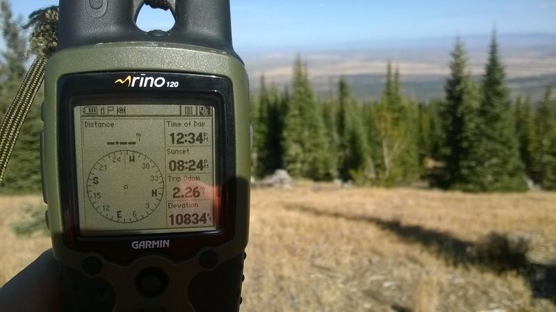
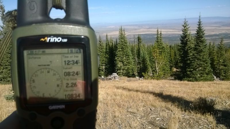
I am currently using a Rhino 120 (discontinued model pictured above) and an Etrex 20 for solo missions or as a back up GPS when I am headed far off grid. I use topo 2008 which is the last Garmin program that is loadable onto unlimited # of GPS units with the same program. Topo maps don't change very fast so I figure I am good for another decade, or as long as the program and maps will work with whatever GPS units are on the market. As always YMMV. |
|
|
|
[#10]
Damn, you guys are giving me GPS envy. I'm still using topo maps and my Garmin eTrex (The original yellow one) that I bought 16 years ago.
|
|
|
|
[#11]
I've had a Garmin 60csx for 10 years? now. It's a fantastic gps. I'd buy a new one, but the 60 just keeps going.
|
|
|
|
[#12]
Quoted:
I've had a Garmin 60csx for 10 years? now. It's a fantastic gps. I'd buy a new one, but the 60 just keeps going. I feel the same way about my old Rino 120... The new Rino model costs over $500 but I think it has evolved enough to be worth the coin... When the old GPS works is it worth it to lay down for a new rig? https://buy.garmin.com/en-US/US/prod533999.html After looking at those new rigs I don't think I would settle for the cheaper out dated 600 series Rino's. Maybe next year? My brother has one of the 600 models, not sure which one exactly but I played with it a little and wasn't super impressed. Other then having a touch/ color screen it didn't do anything significantly different then my 120 to make me go out and buy one. Battery life with my older 120 was better to. Maybe once the 700 series are released for a while they will dip under $500...? |
|
|
|
[#13]
I use a Garmin 62ST, it runs on 2x AAs and that gives it about 12-24 hours of usage without recharging or replacing the batteries.
-You can download .GPX map files from the internet and upload them to your Garmin GPS using Garmin Base Camp (for free). -Using Base Camp you can also download .GPX map data from your Garmin (any garmin even ones without a map) -The map data will display your tracks on the map even with time, and elevation data, you can edit the data points in the software and if you like you can save and export the files as .KMZ and use them overplayed on Google Earth Imagery. Some places don't have free maps available, but most people don't find themselves in need of those maps the entire North American continent is available. 
|
|
|
|
[#14]
My 62st is essential as well. Nothing compares to a real gps. You can download free rasters or topo into the garmin using thier software as well. Ive got a 64 gb micro in it that is no where near filled up even with the world 100 topo, usa 25 topo, and the southeast on birdseye imagery.
One note though, garmins satellite imagery is old, dont know how old, so be warned. |
|
|
|
[#15]
You want a garmin 6x-series. The 64 is the latest but the 62 is still very serviceable. An alternate would be the Etrex 30 (not the 10 or 20).
You may think you want a touchscreen but you really don't. Stay away from the Dakota and Oregon models because of this. For hard field use dedicated buttons are much better. |
|
|
|
[#16]
Bought the etrex 30x due to its barometric altimeter. I'll give it a try in the mountains to see how well it does.
|
|
|
|
[#17]
Quoted:
Bought the etrex 30x due to its barometric altimeter. I'll give it a try in the mountains to see how well it does. The guts inside the etrex30 are about the same as the 6x series. The main difference is the antenna (somewhat better on the 6x) and the button interface. The 6x series gives you more dedicated buttons. That joystick thingy on the 30 is good in theory, but not so good in practice, at least compared to the button complement of the 6x. |
|
|
|
[#18]
Quoted:
Bought the etrex 30x due to its barometric altimeter. I'll give it a try in the mountains to see how well it does. Good choice. I use an Etex 20 and really like it. I use it primarily while hunting or hiking solo. As soon as I join up with others who have Rinos I switch over to that. Topo 2008 is Garmin's last program that has topo maps loadable onto as many GPS units as you like. They are only 100K but look fine on my Etrex 20 and provide more then enough detail for my usage. You can still source this version without much effort. I really want to try a GPSMAP 64st one of these days. Cabela's has them on sale for $300. The 64 is $250. |
|
|
|
[#19]
My old Magellan 315 must be out of date now I guess. I keep thinking about replacing it, but it still gives me gps coords. If I'm smart enough to mark landmarks and waypoints it does its job.
|
|
|
|
[#20]
Quoted:
The guts inside the etrex30 are about the same as the 6x series. The main difference is the antenna (somewhat better on the 6x) and the button interface. The 6x series gives you more dedicated buttons. That joystick thingy on the 30 is good in theory, but not so good in practice, at least compared to the button complement of the 6x. Quoted:
Quoted:
Bought the etrex 30x due to its barometric altimeter. I'll give it a try in the mountains to see how well it does. The guts inside the etrex30 are about the same as the 6x series. The main difference is the antenna (somewhat better on the 6x) and the button interface. The 6x series gives you more dedicated buttons. That joystick thingy on the 30 is good in theory, but not so good in practice, at least compared to the button complement of the 6x. Maybe I am just used to that style of interface but I have been using the Garmin Rino 120 rigs for over a decade now, (which I admit is very much an outdated GPS) all hunting season every season and that's the reason I went with the Etrex 20 is because I wanted similar function. The little joy stick which works find IMHO. I am still on my original Garmin Rino, but over a decade of actual heavy usage during hunting seasons put a lot of wear on the unit. A couple years ago I ordered a fresh exterior case for it that had new buttons and swapped the guts over... Fresh buttons and a fresh screen but the actual unit is the same I have been using for just over a decade. 
I am really trying to get my pack weight down this year for this years 8 day elk archery hunt so I actually ordered one of those Bushnell Backtrack little GPS direction units to serve as a secondary backup rather then carrying two GPS units. Like I posted above my Garmin Rino 120 is old, so its nice to know I have a backup when I am trying to hike a 1/2 mile or so back to the tent/ camp after sitting on a watch until after dark. Not that I would get lost as I feel confident in my compass and map nav, but when your traveling in unknown terrain in the dark of night by headlamp its nice to have an arrow to double check your route. Quoted:
My old Magellan 315 must be out of date now I guess. I keep thinking about replacing it, but it still gives me gps coords. If I'm smart enough to mark landmarks and waypoints it does its job. I love tech, am a ham radio guy, I even built my own computers during my college days but sometimes low tech is good tech. Just like a CCW, or a cell phone, or a guys hiking boots; a GPS can be a very personal thing and one size does not fit all 
Heck, am touting a GPS that is over 10 years old, and has been out of production for several years. |
|
|
|
[#21]
What is the advantage of GPS over a paper map and compass? Hunted deer & elk in the Northern Rockies for many years with a map & compass (weight 2oz) and never got lost.
|
|
|
|
[#22]
Quoted: What is the advantage of GPS over a paper map and compass? Hunted deer & elk in the Northern Rockies for many years with a map & compass (weight 2oz) and never got lost. While there is no substitute for a good map and compass as a backup to the GPS, you have to have a map of the area you're in. A GPS can have maps of the entire US installed. You can also fix your position and know your desired heading w/o being able to see any landmarks. easily tells you precise distance to landmarks (or anywhere for that matter), altitude, elevation change, keeps track of where you've been, so that you can back-track easily. The list goes on and on. They're very, very useful. Until they batteries die, or they break. Then, you're back to map and compass. I'm sure more knowledgeable folks will be along to further answer your question. |
|
|
|
[#23]
Quoted:
What is the advantage of GPS over a paper map and compass? Hunted deer & elk in the Northern Rockies for many years with a map & compass (weight 2oz) and never got lost. Try navigating to a specific point in flat terrain, or heavy vegetation, with just a map and compass. Or extremely rugged terrain where an azimuth and pace count are difficult to maintain. As mentioned, there's no substitute for a map and compass, but a GPS makes focusing on hunting a lot easier in certain terrain instead of staring at a compass and counting in your head as you move. It's nice to be able to look around and maintain situational awareness. |
|
|
|
[#24]
Both above comments are spot on. No one should head into the woods relying on a GPS. Knowing a map and compass are first and foremost IMHO.
A GPS does make it easier. Also allows you to pick a spot 1/2 mile or so away from camp and sit till dark. Navigating in the dark with a map and compass isn't impossible but can be challenging. Doing so with a headlamp and GPS is almost to easy. You can walk right up on your camp site after sitting 1/2 mile away from basecamp like its your job, and in the dark. The peer to peer updating feature on the Garmin Rino units allows you to see others in the group using the same rig if your with in UHF radio range. It is a really good tool. I never head into the woods without at least a compass. GPS is always secondary to a good compass. |
|
|
|
[#25]
Quoted:
Is there a GPS watch that doesn't need charged constantly? I don't know of one....that's a showstopper for me. I'm looking at the Garmin Oregon 600 right now...you can find them for just under $300 if you look around. Quoted:
Quoted:
I like GPS watches that display grid/utm coordinates. I buy maps from mytopo.com for the area I will be in. I would not print your own maps unless you can get the gridlines scaled correctly. Also mytopo.com maps are printed on waterproof paper and are not very expensive. Paper maps normally show detail better than you can get from a small LCD. Also they don't take batteries and are very light. If your GPS dies you can still normally use terrain features to find your location. A GPS watch plus a map is normally lighter and more compact than a GPS with a large display. I'm looking at the Garmin Oregon 600 right now...you can find them for just under $300 if you look around. My Garmin Tactix Bravo lasts about 10 days. I only activate the GPS when I want to locate myself on a map. |
|
|
|
[#26]
I've used the 650T for a year. I like it. When hunting with about 8 other guys that all had similar models, we found locating each other very buggy. sometimes it worked, sometimes not. even when the units were right next to each other, and when we were texting/talking on the 2 way, etc. So I consider that unreliable. also, the touch screen and buttons kinda suck. but they seem very durable.
GLONASS would be interesting and probably worth a few extra bucks. I wonder if it works better the farther north you go |
|
|
|
[#27]
Bump for another thread:
https://www.ar15.com/forums/t_10_17/688226_Cell-Phone-GPS-App-vs--Dedicated-Hand-Held-GPS.html |
|
|
|
[#28]
Quoted:
What is the advantage of GPS over a paper map and compass? Hunted deer & elk in the Northern Rockies for many years with a map & compass (weight 2oz) and never got lost. You live in open, western lands. Long views with fairly open country with topography you can actually see. I live in the SE. Try doing resections in green tunnels or delta pine plantation. My old fave was a Garmin 60csx. My current faves are Etrex 20 and 30. Small, light battery sippers. |
|
|
|
[#29]
Quoted:
You live in open, western lands. Long views with fairly open country with topography you can actually see. I live in the SE. Try doing resections in green tunnels or delta pine plantation. My old fave was a Garmin 60csx. My current faves are Etrex 20 and 30. Small, light battery sippers. Good point. I live in the North East and most of the area I hunt is very heavily wooded. When you can walk 10+ miles and this is the best view that you can get a GPS sure does come in handy. Especially when you are "wandering" or "hunting" and don't feel like counting your paces or following bearings. 
|
|
|
|
[#30]
Quoted:
Damn, you guys are giving me GPS envy. I'm still using topo maps and my Garmin eTrex (The original yellow one) that I bought 16 years ago. Im still using my Magellan 315
|
|
|
|
[#31]
Quoted:
Damn, you guys are giving me GPS envy. I'm still using topo maps and my Garmin eTrex (The original yellow one) that I bought 16 years ago. Don't feel too bad, those old black and white screen GPS units have quite a few basic navigation functions that the newer ones that don't. Batteries last longer too, I'm still rocking a GPS2 (bought in 1994!), an Etrex Legend, an Etrex HCx and recently picked up a GPS2 Plus for $30. Thirty bucks won't even buy a dinner out any more... |
|
|
|
[#32]
Quoted:
Don't feel too bad, those old black and white screen GPS units have quite a few basic navigation functions that the newer ones that don't. Batteries last longer too, I'm still rocking a GPS2 (bought in 1994!), an Etrex Legend, an Etrex HCx and recently picked up a GPS2 Plus for $30. Thirty bucks won't even buy a dinner out any more... Curious; what functions do the old GPS unit have that the new don't? I have owned GPS units going back as far as the Magellan TrailBlazer XL (1993) and I can't think of anything those old units could do that I can't do with my GPSMAP 62s. There are a few things those old units can't do my new unit can. I miss the form factor of the old Garmin GPS II+ and III+ but as far as features go I will take my 62s. |
|
|
|
[#33]
Quoted:
Is there a GPS watch that doesn't need charged constantly? I don't know of one....that's a showstopper for me. I'm looking at the Garmin Oregon 600 right now...you can find them for just under $300 if you look around. I have one of those, they are awesome!! |
|
|
|
[#34]
Quoted:
I have one of those, they are awesome!! I'll say it again, but touchscreens seem nice in the store or sitting in your car, they tend to be a pain in the ass when it's 20 degrees and snowing or raining. I very much encourage anyone looking at hard-use field GPS units to get units with dedicated buttons and not touchscreens. |
|
|
|
[#35]
I would suggest looking at getting a used unit. I made a list of all of the Garmin units that have been made in the past 5 or so years that met my standards. Check here for past models. I then proceeded to look for them on Craiglist, OfferUp and other yard sale type apps. Stay away from ebay prices to high.
I scored a Garmin 550T for $50.00 within about 3 days of looking. I have also seen the Etrex20s (which did everything I wanted to do) for $50-$75. Whatever you do I wouldn't buy one new. The Garmin line seams to be the best for uploading layers to the system. Check out this Site I was able to download a number to layers to my 550T for free. Including GA state WMA and NWF property lines along with trails.  how to screenshot on windows how to screenshot on windows


imgurl |
|
|
|
[#36]
Quoted:
Curious; what functions do the old GPS unit have that the new don't? I have owned GPS units going back as far as the Magellan TrailBlazer XL (1993) and I can't think of anything those old units could do that I can't do with my GPSMAP 62s. There are a few things those old units can't do my new unit can. I miss the form factor of the old Garmin GPS II+ and III+ but as far as features go I will take my 62s. I can't speak to your specific model, but the units I have gotten since the early ones are more consumer oriented and won't do things like navigating to a waypoint based on your current position, a bearing and a distance, calculating land area, tide and fishing times etc. |
|
|
|
[#37]
Quoted:
I can't speak to your specific model, but the units I have gotten since the early ones are more consumer oriented and won't do things like navigating to a waypoint based on your current position, a bearing and a distance, calculating land area, tide and fishing times etc. Maybe with the vehicle orient products and the super low end product like the some of the eTrex line but my GPSMAP 62s can do anything my II+, III+ or GPSMAP78 could do but does it in color and with huge amounts of memory. |
|
|
|
[#38]
Looks like the Garmins are on sale right now, I suspect ditching old inventory for newer models. I picked up the etrex20 for 165 (50 off I think) from B&H
|
|
|
|
[#39]
Quoted:
Looks like the Garmins are on sale right now, I suspect ditching old inventory for newer models. I picked up the etrex20 for 165 (50 off I think) from B&H Right before this past Christmas I picked up a new Garmin Rino 650 for $300 plus tax to my door. Old models out new models in most likely, that said I don't mind have a brand new old model... Cabelas still has a few models on sale as well. |
|
|
 Win a FREE Membership!
Sign up for the ARFCOM weekly newsletter and be entered to win a free ARFCOM membership. One new winner* is announced every week!
You will receive an email every Friday morning featuring the latest chatter from the hottest topics, breaking news surrounding legislation, as well as exclusive deals only available to ARFCOM email subscribers.

AR15.COM is the world's largest firearm community and is a gathering place for firearm enthusiasts of all types.
From hunters and military members, to competition shooters and general firearm enthusiasts, we welcome anyone who values and respects the way of the firearm.

Subscribe to our monthly Newsletter to receive firearm news, product discounts from your favorite Industry Partners, and more.
Copyright © 1996-2024 AR15.COM LLC. All Rights Reserved.
Any use of this content without express written consent is prohibited.
AR15.Com reserves the right to overwrite or replace any affiliate, commercial, or monetizable links, posted by users, with our own.


.jpg)