|
[#1]
Mytopo.com
Custom maps of anywhere & can be printed on waterproof paper. This comes up lots and I know there's some other options but this one's my favorite. |
|
|
|
[#2]
I have access to ArcGIS and some free time. PM me the route you want to take and I'll see what I can do.
|
|
|
|
[#3]
Quoted: I have access to ArcGIS and some free time. PM me the route you want to take and I'll see what I can do. |
|
|
|
[#4]
Ill second Mytopo. they do some nice work and their map has survived several years of repeated storage and use
|
|
|
|
[#5]
Another vote for mytopo. The laminated maps with usgs grids can get pricey fast. If you have access to an open top copier or scanner, you can get away with regular paper maps, but just beginning printer paper sections with you to the field.
Most of the time the regular forest service maps do just fine for me. I do my hunting scouting on Google earth ahead of time, plug everything into my GPS, then use the first service maps for road reference. |
|
|
|
[#6]
caltopo.com is pretty nice
|
|
|
|
[#7]
I'll give another +1 for mytopo.com. Great maps, easy web page, priced right, and quick shipping.
|
|
|
|
[#8]
Mytopo is the bank breaker I was referring to. I'm going to need 16 maps at $30 each. Another $30 to waterproof. that's a lot of cash.
|
|
|
|
[#9]
Google earth with a USGS overlay .kml and a laserjet printer should be pretty good. You have to fuck with it to get sizing right if you plan to use any survey tools on 8.5x11" paper, but if you just need maps you can use in conjunction with a USGS GPS unit, it's awesome.
|
|
|
|
[#10]
By 'satellite maps', do you mean topo maps or satellite images? I simply use google earth, on waterproof paper from www.riteintherain.com or similar.
|
|
|
|
[#11]
I have used Google Map Downloader to create a custom GeoTiff. http://www.allallsoft.com/gmd/
|
|
|
|
[#12]
Massive props to Landsat8, he just hooked me up. 33 map sets (terrain and sat) that cover my entire route home. He did them at 1/4" = 100 yards. Very nice detail, roads and in a hasty defense they can double as range cards. I can accurately estimate range to a target in seconds, down to about 25 yard accuracy with a ruler. I'm going to take my range finder out and see how close I can guess without measuring. 11x17 size means I can carry them all in a small tube on my GHB. I do have a larger overall map to use also, but when I need better detail I'll have easy access. Very impressed. I plan to blow up the ones closet to home to double size (ansi D) and use them for part of my plan there.
|
|
|
|
[#13]
Quoted:
I'm looking to print some custom sat maps for my GHB at the local print shop but I can't figure out the best way to get high res images saved from anywhere without paying a ton. I work 50 miles from home and will have to traverse a lot of urban space. I'm familiar with the routes home, but have high detail maps for each leg would be really handy. I'm going to print several small 11x17 maps that overlap a bit and show maybe 5-6 miles on the width max. I could buy these custom maps but it would break the bank and I'd get fewer with less detail to cover the same area. I realize this might not be the best place to ask, but I don't know where else to. Mods, feel free to move this thread if needed. You said URBAN space there....might I suggest local city maps to add to your base? In addition, you might consider getting a gps that allows downloads of maps...you can then have gps (if it's working) or use it as an electronic map if needed too. 2 is 1, 1 is none..but 3 might work out ok. |
|
|
|
[#14]
I have several local and city maps already, this is to add some detail past just the streets and such. Trying to make it easier to see a clear path.
A good GPS is on my list, but way down. I was great with land nav in the Marine Corps, so it's my first priority. If you have ever been to the Salt Lake valley and around, it's pretty hard to get lost, the mountains make it easy to shoot your location with a compass. I don't start to struggle unit I hit Idaho. |
|
|
|
[#15]
Along the same lines. There was a vendor that has some very tough waterproof paper there. I am not affiliated (other than buying some).
They called it Prepper paper their web site is Prepperpaper.com. I have not used it as I was not sure how to get the route printed out (this thread should help). |
|
|
|
[#17]
Holy Smokes Landsat. Those are nice.
|
|
|
|
[#18]
Quoted: Holy Smokes Landsat. Those are nice. |
|
|
|
[#19]
All I have in my GHB is a county street map that covers from where I work to my house. There are no large tracts of wilderness between so im not too worried about figuring our magnetic to grid and shooting an azimuth.
|
|
|
|
[#20]
Quoted:
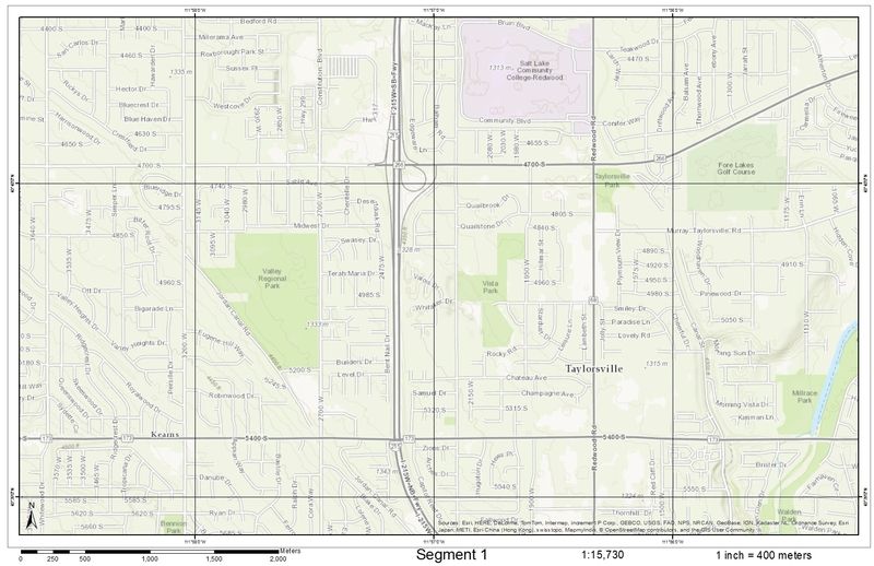
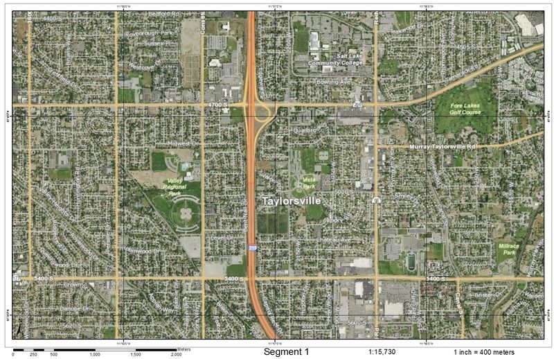
If you want I can scale them up so they print on a larger piece of paper; that way the scale measurement stays the same. If you just blow them up 1in will not = 400 meters. Here are some representative maps of what I made up for lcpl1812.... wouldn't want to blow OPSEC and give away his route so they are of a different area. <a href="http://s16.photobucket.com/user/moulton/media/ar15%20map_zpsnbkxtkrg.jpg.html" target="_blank">http://i16.photobucket.com/albums/b22/moulton/ar15%20map_zpsnbkxtkrg.jpg</a> <a href="http://s16.photobucket.com/user/moulton/media/ar15%20sat_zpsoz7nbqan.jpg.html" target="_blank">http://i16.photobucket.com/albums/b22/moulton/ar15%20sat_zpsoz7nbqan.jpg</a> Quoted:
Quoted:
Massive props to Landsat8, he just hooked me up. 33 map sets (terrain and sat) that cover my entire route home. He did them at 1/4" = 100 yards. Very nice detail, roads and in a hasty defense they can double as range cards. I can accurately estimate range to a target in seconds, down to about 25 yard accuracy with a ruler. I'm going to take my range finder out and see how close I can guess without measuring. 11x17 size means I can carry them all in a small tube on my GHB. I do have a larger overall map to use also, but when I need better detail I'll have easy access. Very impressed. I plan to blow up the ones closet to home to double size (ansi D) and use them for part of my plan there. If you want I can scale them up so they print on a larger piece of paper; that way the scale measurement stays the same. If you just blow them up 1in will not = 400 meters. Here are some representative maps of what I made up for lcpl1812.... wouldn't want to blow OPSEC and give away his route so they are of a different area. <a href="http://s16.photobucket.com/user/moulton/media/ar15%20map_zpsnbkxtkrg.jpg.html" target="_blank">http://i16.photobucket.com/albums/b22/moulton/ar15%20map_zpsnbkxtkrg.jpg</a> <a href="http://s16.photobucket.com/user/moulton/media/ar15%20sat_zpsoz7nbqan.jpg.html" target="_blank">http://i16.photobucket.com/albums/b22/moulton/ar15%20sat_zpsoz7nbqan.jpg</a> Did you buy software to do that? |
|
|
|
[#21]
High detail maps for that much ground might be a logistical problem
I recall when they printed that sort of maps in a bound book for the area around Kandahar The books were quite large and thick, not something I'd want to lug around You might need to scale back your expectations Quoted:
I have access to ArcGIS and some free time. PM me the route you want to take and I'll see what I can do. Interesting. Is that offer open to any of the rest of us? if nothing else I would be able to use some good maps of my county for work purposes. |
|
|
|
[#22]
You can download geoTiffs of USGS quads at Topoquest for FREE.
It's what I use when I need a topo layer in my GIS (Manifold). |
|
|
|
[#23]
Quoted:
Along the same lines. There was a vendor that has some very tough waterproof paper there. I am not affiliated (other than buying some). They called it Prepper paper their web site is Prepperpaper.com. I have not used it as I was not sure how to get the route printed out (this thread should help). Stores such as sportsman's wharehouse also carry the waterproof mapping paper in their map section. My method is a little convoluted, but it works. I use websites like furkot.com and even google maps/earth, I pull up the area I'm interested in, scale it to what I need and then take a screen shot using an evernote add on. This automatically uploads it to my evernote account. I can then go into evernote and print each screen shot. My evernote account also syncs w/ my phone, so I can also pull up the images on my phone and zoom in to check things out. I use furkot to plan out my off-road motorcycle trips and then download the trip to my phone or gps, works nicely. |
|
|
 Win a FREE Membership!
Sign up for the ARFCOM weekly newsletter and be entered to win a free ARFCOM membership. One new winner* is announced every week!
You will receive an email every Friday morning featuring the latest chatter from the hottest topics, breaking news surrounding legislation, as well as exclusive deals only available to ARFCOM email subscribers.

AR15.COM is the world's largest firearm community and is a gathering place for firearm enthusiasts of all types.
From hunters and military members, to competition shooters and general firearm enthusiasts, we welcome anyone who values and respects the way of the firearm.

Subscribe to our monthly Newsletter to receive firearm news, product discounts from your favorite Industry Partners, and more.
Copyright © 1996-2024 AR15.COM LLC. All Rights Reserved.
Any use of this content without express written consent is prohibited.
AR15.Com reserves the right to overwrite or replace any affiliate, commercial, or monetizable links, posted by users, with our own.