|
[#1]
Tag for good info! Also looking.
|
|
|
|
[#2]
Quoted:
Whats a good not over priced hand held GPS unit for hiking and hunting? Iphone...if you already have one... |
|
|
|
[#3]
Garmin GPS 60CSx
|
|
|
|
[#4]
Bushnell Backtracker.
|
|
|
|
[#5]
Garmin Etrex off Ebay. The older ones are dirt cheap, but take a while (2-3 min to get to 20 ft. accuracy) to get a fix. They also use batteries a bit faster, but I use only alkalines- I haven't tried a lithium set. I have an old Vista, and it's been everywhere with me. It's pretty damn rugged, and dustproof and waterproof. The screen a bit frosted in a corner, but just visible as a defect, not detracting from the screen view in any way. If you're worried about that, get some generic screen protectors and cut to fit. The only downside I can think of is mine is so old the updating cable is RS-232, so I keep an ancient laptop on hand just for it.
|
|
|
|
[#6]
pretty happy with my etrex 20 with upgraded map pack
|
|
|
|
[#7]
I have a Gamin Rino 120... If you don't need or want the radio portion I would suggest a Garmin Etrex20 and a copy of garmins TOPO 2008...
I belive the etrex20 uses USB for transfer, where my older 120s use serial so I need a to use a GOOD adapter, cheap ones from ebay time out after about 10 seconds which can brick a GPS. Garmin TOPO 2008 is the last map pack from gamin that is loadable onto multiple devices. So you get a good 100k topo map set that covers the USA and will last as long as you want through as many devices as you want... So long as it will install on your operating system. Works on windows XP and 7 as I understand it. You can find it TOPO 2008 on ebay brand new for around $50... I have a copy brand new sealed in a blister pack still! Or if you are resourceful you can find it through other means. It is after all a 6 year old program Garmin TOPO USA 2008 v4
2.71GB Fortunately TOPO maps don't change much over the years. 
TOPO maps make a GPS very useful but if you are just looking for direction and lat/lon you can get a decent one for a bit cheaper. No TOPO 2008 is not going to look like the 24K maps they offer now but it also wont cost you $100 per device. Etrex20: http://www.amazon.com/Garmin-eTrex-Worldwide-Handheld-Navigator/dp/B00542NVDW/ref=sr_1_1?ie=UTF8&qid=1406992943&sr=8-1&keywords=garmin+etrex+20 or http://www.walmart.com/ip/Garmin-eTrex-20-2.2-Portable-GPS/17167613 TOPO: http://www.ebay.com/itm/GARMIN-TOPO-US-2008-Mapsource-DVD-P-N-010-11001-00-Topographic-Maps-Aviation-/281320686009?pt=GPS_Maps_Software&hash=item41800501b9 or http://www.ebay.com/itm/GPS-MAPSOURCE-TOPO-US-2008-GARMIN-GPSMAP-MAC-WINDOWS-ETREX-CSx-60-CSx-76C-Sx-/251588332501?pt=GPS_Maps_Software&hash=item3a93d54bd5 |
|
|
|
[#8]
I'm shopping around for the same thing you are OP. I think I'm going to end up getting a Bushnell BackTrack D-Tour.
|
|
|
|
[#9]
Quoted:
Garmin GPS 60CSx I have one of these and like it. |
|
|
|
[#10]
Quoted:
I have one of these and like it. Quoted:
Quoted:
Garmin GPS 60CSx I have one of these and like it. I love mine when I was looking for a new one this is what everyone recommended it is very easy to use and garmin customer service is the best |
|
|
|
[#11]
For heavens sake, don't get the really old models, the sensor loses the signal too easy.
The newer vistas are nice. I have a astro 320 which is like the 62. I can track my dogs with it ( I have the collars) |
|
|
|
[#12]
I just got an Etrex20 to go along with my Rino 120. I will use it as a backup GPS or when I am out and don't need the peer to peer updating feature of the Rinos.
I have only used it a couple times so far, but with the 100k topo 2008 map set it looks great IMO. Not 24k pretty but plenty good enough for wilderness navigation. The color display beats the older Rinos to. The one thing I would say, is that the Etrex line is pretty small, so if you are looking for a small light weight battery efficient GPS that acquires GPS signals very quickly then I would recommend an Etrex 20... Won't break the bank ether. |
|
|
|
[#13]
Garmin foretrex 401
|
|
|
|
[#14]
Whatever you get, be aware that you do not have to purchase topo maps. You can get maps at http://www.gpsfiledepot.com/index.php. I got the SE topo map, it's awesome! I can only put a little bit of it on my vista but at least in only takes minutes. I can put it all on my astros
I subscribed to the garmin sat image thing, forget what it's called, found it useless. Plus I can use my phone for sat images. It's just a bunch of treetops. Learn to use your gps before you need to use it. It's only a tool. I still carry a compass, mostly to check the electronic compass on the gps. If that is off then everything you look at will be off. Because I live where it's flat and swampy, there aren't any real landmarks to utilize my mad orienteering skillz  but the compass still comes in handy when I'm in the deep dark brush and disoriented. Mostly to check the gps. but the compass still comes in handy when I'm in the deep dark brush and disoriented. Mostly to check the gps.
Always carry spare batteries. Make sure something bright is on the GPS in case you drop it. I don't know why they insist on making them and the cases black or green. Back to the features - the little book will only tell you how they work, not when you should use them. There is a gps strategy to develop. I always clear my track log before I set out. I always waypoint my entry point, atv, truck, and/or various other points along the way. Make sure your compass is calibrated, otherwise it will be off. If it shifts when you start moving that is a clue because the electronic compass switches off after movement and it uses satellites to determine north and stuff. Sometimes it's better to navigate by "goto" or instead of backtracking. Especially when you've trampled all around in an overgrown area. Your tracks will look like spaghetti, and you don't really need to follow the exact same track you went in, on the way out. It's very dense and overgrown where I am apt to go. The vines and briars are ethereal, you can literally have your clothes torn off your body. I have frequently "fallen" and hung there like a puppet because of the vines. I carry a small pair of pruners to help in getting detangled. In cases like this you only need to find a clear path in the general direction you need to go in. Trying to pick out the exact footsteps isn't necessary. Don't forget to save your tracks after you get back, or whenever you need to save them. It sucks to forget to clear the tracklog if you are using your gps to log miles, or whatever, then have superfluous miles on a track, when all you need is that little track. Learning to use handheld GPS's have changed my outdoor life! I used to run my beagles and sometimes they won't come back, or for whatever reason you have to see what they are doing. I am usually the only one willing to go into thick dark underbrush, at night, because I have the tools to do it and not get lost (I also carry a powerful headlamp or two, and spare batteries). I can follow a blood trail at night and recover a deer because I can determine where I've looked and where I need to go. Everyone I know that navigates with their "awesome sense of direction" either gets lost, or doesn't go. Of course this isn't the wild west, it's eastern swampy brush. Getting lost is an inconvenience and embarrassment but probably not death. I have some videos of me going through the brush but I'm not brave enough to post them today. Plus, if you stick your head in a bucket of lettuce, with some thorns thrown in, you get the idea. I do have these cool maps I've made. I take my tracks and data I've saved on my gps, and go to http://www.gpsvisualizer.com/ and make a "map" This is pretty cool when you want a friend to find your stand, or to map an area. 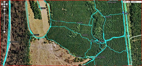
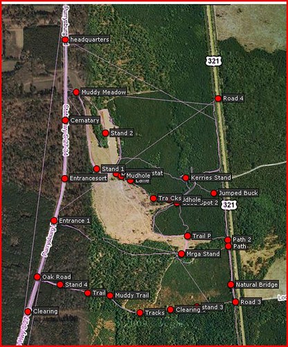
Just a couple examples. They are mostly useful for groups that hunt in the same area, so everyone knows where everything is. The straight lines are from where I stopped the track log, then started it again. It connected them with a line.  That's why I save and clear now, so I have nice pretty maps. I made those on a garmin vista, which only held 10 or 20 tracks, my new ones hold 200! That's why I save and clear now, so I have nice pretty maps. I made those on a garmin vista, which only held 10 or 20 tracks, my new ones hold 200!
You can save all this data on your computer and name them. That way you can load them onto other units, view the data on that link I posted, or just clear your unit to make room for more waypoints. Somewhere in those maps are where I got these guys!! 
That place was overrun with pigs! 
It was a swampy lowcountry wetland paradise 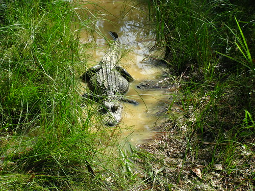
first pig!!!! It was hot humid and rainy that day. Got it at dusk and had to drag it out at night. 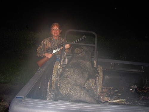
view from a stand 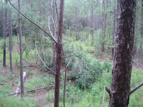
It's hot as heck here. It was over 102 this day with lots of humidity. One of our group got sick. 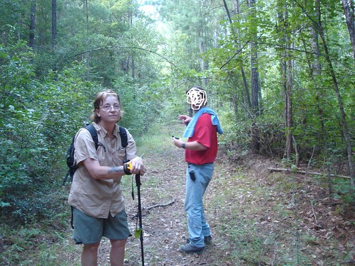
So get that gps and practice with it. They can contribute to the fun you have in the outdoors. |
|
|
|
[#15]
Gitarmac, your post has some good info, thanks.
OP, I downloaded an app on my android called Backcounty Navigator Pro for $13. I just tracked a two night, 3 day trip with it and it worked perfectly. You still have gps signal with a phone even when you don't have service. If you're concerned about battery life, shut the phone off and only turn it on to get oriented. Or, do like me and root your phone, remove all the bullshit spyware/bloatware, and get 3 days out of a single charge |
|
|
|
[#16]
I have an eTrex Vista HCx and a Foretrex 401. I use the 401 the most, but most of my gps use is for waypoint marking and tracking distance and elevation. I rarely use the map functions. The foretrex is small and can be worn on your wrist like a watch. Their are newer more compact versions available, so you can find it a lot cheaper than it used to be.
|
|
|
|
[#17]
I picked up a used Garmin GPSMap60CxS for $60. Upgraded on-board memory chip to the 4 GB max, and bought a few accesories, such as a certified GTG cable, car/12v power unit, case, and some other stuff. The gpsfilesdepot maps site linked above was extremely useful, and I reckon the hotlinked site above would also prove useful as well.
If you buy a used unit, you will want to ensure that Garmin still supports it with firmware/software updates, that a user's manual is still available for download, as well as ancillary peripherals. You will also want to ensure that the free map sites offer compatible downloads as well. Garmin still supports my 60CsX with all the above, and other items are available on Amazon. FWIW, my Garmin fits perfectly in a small USGI MOLLE flash-bang pouch. |
|
|
 Win a FREE Membership!
Sign up for the ARFCOM weekly newsletter and be entered to win a free ARFCOM membership. One new winner* is announced every week!
You will receive an email every Friday morning featuring the latest chatter from the hottest topics, breaking news surrounding legislation, as well as exclusive deals only available to ARFCOM email subscribers.

AR15.COM is the world's largest firearm community and is a gathering place for firearm enthusiasts of all types.
From hunters and military members, to competition shooters and general firearm enthusiasts, we welcome anyone who values and respects the way of the firearm.

Subscribe to our monthly Newsletter to receive firearm news, product discounts from your favorite Industry Partners, and more.
Copyright © 1996-2024 AR15.COM LLC. All Rights Reserved.
Any use of this content without express written consent is prohibited.
AR15.Com reserves the right to overwrite or replace any affiliate, commercial, or monetizable links, posted by users, with our own.